
FCCInfo.com
A Service of Cavell, Mertz & Associates, Inc.
(855) FCC-INFO
|
|
|
|
|
||||||||||||||||
|
|
Status: Construction Permit Application Accepted: 06/29/2021 K17LP-D CP Expires: 06/30/2024 File Number: -0000151167 FCC Website Links: LMS Facility Details This Application Other K17LP-D Applications Including Superseded Applications Mailing Address Correspondence for K17LP-D Correspondence related to application -0000151167 Service Contour - Open Street Map or USGS Map (51 dBu) Service Contour - KML / Google Earth (51 dBu) Rabbit Ears Info Search for K17LP-D Site Location: 36-41-46.0 N 108-13-15.3 W (NAD 83) Site Location: 36-41-46.0 N 108-13-13.0 W (Converted to NAD 27) ERP: 5 kW Polarization: Elliptically polarized Electrical Beam Tilt: 1.0 degree R/C AGL: 40 m (131 ft.) R/C AMSL: 1820 m (5971 ft.) Emission Mask: Full Service Site Elevation: 1780 m. (5840 ft.) Height Overall*: 64.6 m (212 ft.) (* As Filed In This Application, may differ from ASR Data, Below.) Directional Antenna - Antenna Make/Model: Scala 2x2 750 10325 Antenna ID: 1008342 Polarization: Elliptically polarized | ||||||||||||||||||
| Antenna Data for Antenna Id: 1008342 K17LP-D LD File: -0000151167 Scala - 2x2 750 10325 Service: LD Standard Pattern: N Pattern and Field Values Include a 45° Clockwise Rotation | 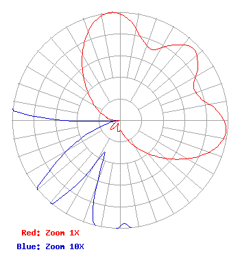 | ||||||||||||||||||
| Azimuth | Ratio | Azimuth | Ratio | Azimuth | Ratio | Azimuth | Ratio | ||||||||||||
| 5 | 0.936 | 15 | 0.778 | 25 | 0.719 | 35 | 0.846 | ||||||||||||
| 45 | 0.947 | 55 | 0.881 | 65 | 0.752 | 75 | 0.774 | ||||||||||||
| 85 | 0.911 | 95 | 0.987 | 105 | 0.934 | 115 | 0.798 | ||||||||||||
| 125 | 0.631 | 135 | 0.473 | 145 | 0.335 | 155 | 0.233 | ||||||||||||
| 165 | 0.150 | 175 | 0.099 | 185 | 0.103 | 195 | 0.096 | ||||||||||||
| 205 | 0.033 | 215 | 0.078 | 225 | 0.123 | 235 | 0.077 | ||||||||||||
| 245 | 0.039 | 255 | 0.011 | 265 | 0.012 | 275 | 0.099 | ||||||||||||
| 285 | 0.144 | 295 | 0.227 | 305 | 0.324 | 315 | 0.449 | ||||||||||||
| 325 | 0.610 | 335 | 0.784 | 345 | 0.935 | 355 | 1.000 | ||||||||||||
Structure Registration Number 1057687 Structure Type: TOWER Registered To: AYOUB, FAREED Structure Address: 1.85 Miles South Of The Intersection Of Sr 371 And Murray Drive, San Juan County Farmington, NM County Name: San Juan County ASR Issued: 10/04/2005 Date Built: 11/29/2005 Site Elevation: 1780 m (5840 ft.) Structure Height: 63.7 m (209 ft.) Height Overall: 64.6 m (212 ft.) Overall Height AMSL: 1844.6 m (6052 ft.) FAA Determination: 09/23/2005 FAA Study #: 2005-ASW-5047-OE FAA Circular #: 70/7460-1K Paint & Light FAA Chapters: 3, 4, 5, 12 PRIOR STUDY 2004-ASW-2160-OE 36-41-46.0 N 108-13-15.3 W (NAD 83) 36-41-46.0 N 108-13-13.0 W (Converted to NAD 27) |
711 Tappen Shire Colleyville, TX 76034 Phone: 214-770-7770 Limited Liability Company | Title: Member/manager Date: 06/29/2021 Application Certifier Fidelitv, Llc 711 Tappen Shire Colleyville, TX 76034 Applicant Susan Hansen B. W. St. Clair 2305 Vida Shaw Rd. New Iberia, LA 70563 Consultant | |||||||||||||||||