
FCCInfo.com
A Service of Cavell, Mertz & Associates, Inc.
(855) FCC-INFO
|
|
|
|
|
||||||||||||||||
|
|
Status: Construction Permit Application Accepted: 06/29/2021 K32JT-D CP Expires: 06/08/2024 File Number: -0000151169 FCC Website Links: LMS Facility Details This Application Other K32JT-D Applications Including Superseded Applications Mailing Address Correspondence for K32JT-D Correspondence related to application -0000151169 Service Contour - Open Street Map or USGS Map (51 dBu) Service Contour - KML / Google Earth (51 dBu) Rabbit Ears Info Search for K32JT-D Site Location: 36-41-46.0 N 108-13-15.3 W (NAD 83) Site Location: 36-41-46.0 N 108-13-13.0 W (Converted to NAD 27) ERP: 2 kW Polarization: Elliptically polarized R/C AGL: 40 m (131 ft.) R/C AMSL: 1820 m (5971 ft.) Emission Mask: Full Service Site Elevation: 1780 m. (5840 ft.) Height Overall*: 64.6 m (212 ft.) (* As Filed In This Application, may differ from ASR Data, Below.) Directional Antenna - Antenna Make/Model: Kathrein 2x1 750 10325 Panel Antenna ID: 1007994 Polarization: Elliptically polarized | ||||||||||||||||||
| Antenna Data for Antenna Id: 1007994 K32JT-D LD File: -0000151169 Kathrein - 2x1 750 10325 Panel Service: LD Standard Pattern: Y Pattern and Field Values Include a 90° Clockwise Rotation | 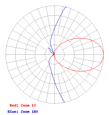 | ||||||||||||||||||
| Azimuth | Ratio | Azimuth | Ratio | Azimuth | Ratio | Azimuth | Ratio | ||||||||||||
| 0 | 0.053 | 10 | 0.085 | 20 | 0.138 | 30 | 0.221 | ||||||||||||
| 40 | 0.338 | 50 | 0.489 | 60 | 0.659 | 70 | 0.822 | ||||||||||||
| 80 | 0.947 | 90 | 1.000 | 100 | 0.961 | 110 | 0.846 | ||||||||||||
| 120 | 0.684 | 130 | 0.510 | 140 | 0.356 | 150 | 0.235 | ||||||||||||
| 160 | 0.148 | 170 | 0.092 | 180 | 0.056 | 190 | 0.036 | ||||||||||||
| 200 | 0.027 | 210 | 0.022 | 220 | 0.017 | 230 | 0.010 | ||||||||||||
| 240 | 0.005 | 250 | 0.002 | 260 | 0.001 | 270 | 0.001 | ||||||||||||
| 280 | 0.001 | 290 | 0.002 | 300 | 0.006 | 310 | 0.012 | ||||||||||||
| 320 | 0.017 | 330 | 0.002 | 340 | 0.025 | 350 | 0.036 | ||||||||||||
Structure Registration Number 1057687 Structure Type: TOWER Registered To: AYOUB, FAREED Structure Address: 1.85 Miles South Of The Intersection Of Sr 371 And Murray Drive, San Juan County Farmington, NM County Name: San Juan County ASR Issued: 10/04/2005 Date Built: 11/29/2005 Site Elevation: 1780 m (5840 ft.) Structure Height: 63.7 m (209 ft.) Height Overall: 64.6 m (212 ft.) Overall Height AMSL: 1844.6 m (6052 ft.) FAA Determination: 09/23/2005 FAA Study #: 2005-ASW-5047-OE FAA Circular #: 70/7460-1K Paint & Light FAA Chapters: 3, 4, 5, 12 Removed expiration date from determination. Scenario 1./jjs/case#635066 36-41-46.0 N 108-13-15.3 W (NAD 83) 36-41-46.0 N 108-13-13.0 W (Converted to NAD 27) |
Hurst, TX 76054 Phone: 214-770-7770 Corporation | Title: Ceo Date: 06/29/2021 Application Certifier EDGE SPECTRUM, INC. Edge Spectrum, Inc. Hurst, TX 76054 Applicant Susan Hansen B. W. St. Clair 2305 Vida Shaw Rd. New Iberia, LA 70563 Consultant Randy Weiss Edge Spectrum, Inc. Hurst, TX 76054 CEO Caleb Weiss Ark Multicasting, Inc. Cedar Hill, TX 75106 President | |||||||||||||||||