
FCCInfo.com
A Service of Cavell, Mertz & Associates, Inc.
(855) FCC-INFO
|
|
KHXL-LD from 06/19/1997 KHXL-LD from 01/22/1985 |
|
|
||||||||||||||||
|
|
Status: License Application Accepted: 07/07/2021 License Expires: 08/01/2022 File Number: -0000151857 FCC Website Links: LMS Facility Details This Application Other KHXL-LD Applications Including Superseded Applications Mailing Address Correspondence for KHXL-LD Correspondence related to application -0000151857 Service Contour - Open Street Map or USGS Map (48 dBu) Service Contour - KML / Google Earth (48 dBu) Rabbit Ears Info Search for KHXL-LD Site Location: 30-42-12.5 N 95-28-33.6 W (NAD 83) Site Location: 30-42-11.8 N 95-28-32.8 W (Converted to NAD 27) ERP: 0.1 kW Polarization: Horizontally polarized R/C AGL: 6 m (20 ft.) R/C AMSL: 131.4 m (431 ft.) Emission Mask: Full Service Site Elevation: 125.4 m. (411 ft.) Height Overall*: 194.1 m (637 ft.) (* As Filed In This Application, may differ from ASR Data, Below.) Directional Antenna - Antenna Make/Model: Scala CL-1469 Antenna ID: 20778 Polarization: Horizontally polarized | ||||||||||||||||||
| Antenna Data for Antenna Id: 20778 KHXL-LD LD File: -0000151857 Scala - CL-1469 Service: LD Standard Pattern: Y Pattern and Field Values Include a 295° Clockwise Rotation | 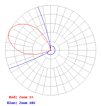 | ||||||||||||||||||
| Azimuth | Ratio | Azimuth | Ratio | Azimuth | Ratio | Azimuth | Ratio | ||||||||||||
| 5 | 0.010 | 15 | 0.010 | 25 | 0.010 | 35 | 0.010 | ||||||||||||
| 45 | 0.010 | 55 | 0.010 | 65 | 0.010 | 75 | 0.010 | ||||||||||||
| 85 | 0.010 | 95 | 0.010 | 105 | 0.010 | 115 | 0.010 | ||||||||||||
| 125 | 0.010 | 135 | 0.010 | 145 | 0.010 | 155 | 0.010 | ||||||||||||
| 165 | 0.010 | 175 | 0.010 | 185 | 0.010 | 195 | 0.010 | ||||||||||||
| 205 | 0.010 | 215 | 0.010 | 225 | 0.010 | 235 | 0.010 | ||||||||||||
| 245 | 0.086 | 255 | 0.361 | 265 | 0.622 | 275 | 0.812 | ||||||||||||
| 285 | 0.947 | 295 | 1.000 | 305 | 0.947 | 315 | 0.812 | ||||||||||||
| 325 | 0.622 | 335 | 0.361 | 345 | 0.086 | 355 | 0.010 | ||||||||||||
Structure Registration Number 1053388 Structure Type: GTOWER Registered To: EIP Holdings II, LLC Structure Address: 0.18 Miles Sw Of The Intersection Of Hwy 190 And Old Phelps Rd. Huntsville, TX County Name: Walker County ASR Issued: 11/30/2023 Date Built: 12/01/1993 Site Elevation: 125.4 m (411 ft.) Structure Height: 189 m (620 ft.) Height Overall: 194.1 m (637 ft.) Overall Height AMSL: 319.5 m (1048 ft.) FAA Determination: 06/17/2020 FAA Study #: 2020-ASW-7793-OE FAA Circular #: 70/7460-1L Paint & Light FAA Chapters: 4, 8, 12 PRIOR STUDY 1992-ASW-1889-OE 30-42-12.5 N 95-28-33.6 W (NAD 83) 30-42-11.8 N 95-28-32.8 W (Converted to NAD 27) |
Hurst, TX 76054 Phone: 214-770-7770 Corporation | Title: Ceo Date: 07/07/2021 Application Certifier EDGE SPECTRUM, INC. Edge Spectrum, Inc. Hurst, TX 76054 Applicant Susan Hansen B. W. St. Clair 2305 Vida Shaw Rd. New Iberia, LA 70563 Consultant Randy Weiss Edge Spectrum, Inc. Hurst, TX 76054 CEO Caleb Weiss Ark Multicasting, Inc. Cedar Hill, TX 75106 President | |||||||||||||||||