
FCCInfo.com
A Service of Cavell, Mertz & Associates, Inc.
(855) FCC-INFO
|
|
|
|
|
||||||||||||||||
|
|
Status: License Application Accepted: 07/07/2021 License Expires: 12/01/2022 File Number: -0000151862 FCC Website Links: LMS Facility Details This Application Other K16JJ-D Applications Including Superseded Applications Mailing Address Correspondence for K16JJ-D Correspondence related to application -0000151862 Service Contour - Open Street Map or USGS Map (51 dBu) Service Contour - KML / Google Earth (51 dBu) Rabbit Ears Info Search for K16JJ-D Site Location: 40-43-49.4 N 123-57-11.6 W (NAD 83) Site Location: 40-43-49.9 N 123-57-07.4 W (Converted to NAD 27) ERP: 0.1 kW Polarization: Horizontally polarized R/C AGL: 6 m (20 ft.) R/C AMSL: 863.7 m (2834 ft.) Emission Mask: Stringent Site Elevation: 857.7 m. (2814 ft.) Height Overall*: 77.7 m (255 ft.) (* As Filed In This Application, may differ from ASR Data, Below.) Directional Antenna - Antenna Make/Model: Scala CL-1469 Antenna ID: 20778 Polarization: Horizontally polarized | ||||||||||||||||||
| Antenna Data for Antenna Id: 20778 K16JJ-D LD File: -0000151862 Scala - CL-1469 Service: LD Standard Pattern: Y | 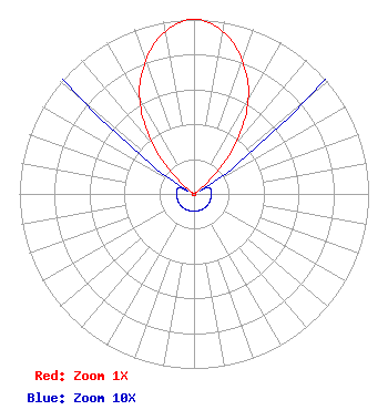 | ||||||||||||||||||
| Azimuth | Ratio | Azimuth | Ratio | Azimuth | Ratio | Azimuth | Ratio | ||||||||||||
| 0 | 1.000 | 10 | 0.947 | 20 | 0.812 | 30 | 0.622 | ||||||||||||
| 40 | 0.361 | 50 | 0.086 | 60 | 0.010 | 70 | 0.010 | ||||||||||||
| 80 | 0.010 | 90 | 0.010 | 100 | 0.010 | 110 | 0.010 | ||||||||||||
| 120 | 0.010 | 130 | 0.010 | 140 | 0.010 | 150 | 0.010 | ||||||||||||
| 160 | 0.010 | 170 | 0.010 | 180 | 0.010 | 190 | 0.010 | ||||||||||||
| 200 | 0.010 | 210 | 0.010 | 220 | 0.010 | 230 | 0.010 | ||||||||||||
| 240 | 0.010 | 250 | 0.010 | 260 | 0.010 | 270 | 0.010 | ||||||||||||
| 280 | 0.010 | 290 | 0.010 | 300 | 0.010 | 310 | 0.086 | ||||||||||||
| 320 | 0.361 | 330 | 0.622 | 340 | 0.812 | 350 | 0.947 | ||||||||||||
Structure Registration Number 1048503 Structure Type: GTOWER Registered To: Vertical Bridge Towers III, LLC Structure Address: 8998 Kneeland Rd / Us-ca-5118 Kneeland, CA County Name: Humboldt County ASR Issued: 09/05/2018 Date Built: 01/01/1984 Site Elevation: 857.7 m (2814 ft.) Structure Height: 60.8 m (199 ft.) Height Overall: 77.7 m (255 ft.) Overall Height AMSL: 935.4 m (3069 ft.) FAA Determination: 08/03/2018 FAA Study #: 2018-AWP-12715-OE FAA Circular #: 70/7460-1L Paint & Light FAA Chapters: 4, 8, 12 PRIOR STUDY 2017-AWP-10617-OE 40-43-49.4 N 123-57-11.6 W (NAD 83) 40-43-49.9 N 123-57-07.4 W (Converted to NAD 27) |
Hurst, TX 76054 Phone: 214-770-7770 Corporation | Title: Ceo Date: 07/07/2021 Application Certifier EDGE SPECTRUM, INC. Edge Spectrum, Inc. Hurst, TX 76054 Applicant Susan Hansen B. W. St. Clair 2305 Vida Shaw Rd. New Iberia, LA 70563 Consultant Randy Weiss Edge Spectrum, Inc. Hurst, TX 76054 CEO Caleb Weiss Ark Multicasting, Inc. Cedar Hill, TX 75106 President | |||||||||||||||||