
FCCInfo.com
A Service of Cavell, Mertz & Associates, Inc.
(855) FCC-INFO
|
|
WTAS-LD from 11/25/1996 WTAS-LD from 01/04/1989 |
|
|
||||||||||||||||
|
|
Status: License Application Accepted: 07/08/2021 License Expires: 12/01/2021 File Number: -0000151967 FCC Website Links: LMS Facility Details This Application Other WTAS-LD Applications Including Superseded Applications Mailing Address Correspondence for WTAS-LD Correspondence related to application -0000151967 Service Contour - Open Street Map or USGS Map (51 dBu) Service Contour - KML / Google Earth (51 dBu) Rabbit Ears Info Search for WTAS-LD Site Location: 42-58-05.0 N 88-11-20.1 W (NAD 83) Site Location: 42-58-05.0 N 88-11-19.8 W (Converted to NAD 27) ERP: 15 kW Polarization: Elliptically polarized Electrical Beam Tilt: 4.0 degrees R/C AGL: 137 m (449 ft.) R/C AMSL: 455.1 m (1493 ft.) Emission Mask: Full Service Site Elevation: 318.1 m. (1044 ft.) Height Overall*: 149 m (489 ft.) (* As Filed In This Application, may differ from ASR Data, Below.) Directional Antenna - Antenna Make/Model: Anywave 2X1 UTVC-01 Panel Array Antenna ID: 1008394 Polarization: Elliptically polarized | ||||||||||||||||||
| Antenna Data for Antenna Id: 1008394 WTAS-LD LD File: -0000151967 Anywave - 2X1 UTVC-01 Panel Array Service: LD Standard Pattern: N Pattern and Field Values Include a 55° Clockwise Rotation | 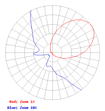 | ||||||||||||||||||
| Azimuth | Ratio | Azimuth | Ratio | Azimuth | Ratio | Azimuth | Ratio | ||||||||||||
| 5 | 0.380 | 15 | 0.530 | 25 | 0.690 | 35 | 0.840 | ||||||||||||
| 45 | 0.950 | 55 | 1.000 | 65 | 0.970 | 75 | 0.870 | ||||||||||||
| 85 | 0.730 | 95 | 0.570 | 105 | 0.410 | 115 | 0.290 | ||||||||||||
| 125 | 0.190 | 135 | 0.130 | 145 | 0.090 | 155 | 0.060 | ||||||||||||
| 165 | 0.050 | 175 | 0.040 | 185 | 0.030 | 195 | 0.030 | ||||||||||||
| 205 | 0.030 | 215 | 0.010 | 225 | 0.010 | 235 | 0.010 | ||||||||||||
| 245 | 0.010 | 255 | 0.020 | 265 | 0.040 | 275 | 0.030 | ||||||||||||
| 285 | 0.030 | 295 | 0.040 | 305 | 0.050 | 315 | 0.060 | ||||||||||||
| 325 | 0.080 | 335 | 0.110 | 345 | 0.170 | 355 | 0.250 | ||||||||||||
Structure Registration Number 1054380 Structure Type: TOWER Registered To: Global Tower, LLC. through American Towers, LLC Structure Address: S42 W22080 Beeheim Rd Waukesha, WI County Name: Waukesha County ASR Issued: 08/29/2014 Date Built: 09/28/2006 Site Elevation: 318.1 m (1044 ft.) Structure Height: 149 m (489 ft.) Height Overall: 149 m (489 ft.) Overall Height AMSL: 467.1 m (1532 ft.) FAA Determination: 09/26/2009 FAA Study #: 2009-AGL-4567-OE FAA Circular #: 70/7460-1K Paint & Light FAA Chapters: 4, 8, 12 PRIOR STUDY 2009-AGL-3235-OE 42-58-05.0 N 88-11-20.1 W (NAD 83) 42-58-05.0 N 88-11-19.8 W (Converted to NAD 27) |
136 East Walker Milwaukee, WI 53204 Phone: 000-000-0000 Limited Liability Company | Title: Partner Date: 07/08/2021 Application Certifier Waukesha Tower Associates Lp 136 E. Walker Street Milwaukee, WI 53204 Applicant Kevin T. Fisher Smith And Fisher, Llc 4791 Wintergreen Court Woodbridge, VA 22192 Engineering Consultant JOHN NEELY, ESQ, Miller And Neely, P.c. 4 Simms Court Kensington, MD 20895 | |||||||||||||||||