
FCCInfo.com
A Service of Cavell, Mertz & Associates, Inc.
(855) FCC-INFO
|
|
|
|
|
||||||||||||||||
|
|
Status: License Application Accepted: 07/07/2021 License Expires: 12/01/2021 File Number: -0000151894 FCC Website Links: LMS Facility Details This Application Other W33DH-D Applications Including Superseded Applications Mailing Address Correspondence for W33DH-D Correspondence related to application -0000151894 Service Contour - Open Street Map or USGS Map (51 dBu) Service Contour - KML / Google Earth (51 dBu) Rabbit Ears Info Search for W33DH-D Site Location: 44-48-00.0 N 91-27-57.0 W (NAD 83) Site Location: 44-48-00.1 N 91-27-56.4 W (Converted to NAD 27) ERP: 15 kW Polarization: Elliptically polarized Electrical Beam Tilt: 0.5 degrees R/C AGL: 131.1 m (430 ft.) R/C AMSL: 402 m (1319 ft.) Emission Mask: Full Service Site Elevation: 270.9 m. (889 ft.) Height Overall*: 293 m (961 ft.) (* As Filed In This Application, may differ from ASR Data, Below.) Directional Antenna - Antenna Make/Model: DIELECTRIC TLP-8H/VP Antenna ID: 1008072 Polarization: Elliptically polarized | ||||||||||||||||||
| Antenna Data for Antenna Id: 1008072 W33DH-D LD File: -0000151894 DIELECTRIC - TLP-8H/VP Service: LD Standard Pattern: N | 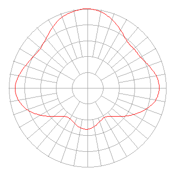 | ||||||||||||||||||
| Azimuth | Ratio | Azimuth | Ratio | Azimuth | Ratio | Azimuth | Ratio | ||||||||||||
| 0 | 1.000 | 10 | 0.977 | 20 | 0.917 | 30 | 0.842 | ||||||||||||
| 40 | 0.776 | 50 | 0.768 | 60 | 0.779 | 70 | 0.828 | ||||||||||||
| 80 | 0.885 | 90 | 0.911 | 100 | 0.880 | 110 | 0.788 | ||||||||||||
| 120 | 0.673 | 130 | 0.560 | 140 | 0.467 | 150 | 0.430 | ||||||||||||
| 160 | 0.452 | 170 | 0.495 | 180 | 0.521 | 190 | 0.511 | ||||||||||||
| 200 | 0.477 | 210 | 0.446 | 220 | 0.468 | 230 | 0.560 | ||||||||||||
| 240 | 0.688 | 250 | 0.810 | 260 | 0.891 | 270 | 0.918 | ||||||||||||
| 280 | 0.885 | 290 | 0.834 | 300 | 0.793 | 310 | 0.777 | ||||||||||||
| 320 | 0.816 | 330 | 0.885 | 340 | 0.949 | 350 | 0.984 | ||||||||||||
Structure Registration Number 1033663 Structure Type: TOWER Registered To: Gray Media Group, Inc. Structure Address: 1907 S Hastings Way Eau Claire, WI County Name: Eau Claire County ASR Issued: 09/09/2020 Date Built: 09/25/1956 Site Elevation: 270.9 m (889 ft.) Structure Height: 270.7 m (888 ft.) Height Overall: 293 m (961 ft.) Overall Height AMSL: 563.9 m (1850 ft.) FAA Determination: 08/03/1998 FAA Study #: 98-AGL-0904-OE Paint & Light FAA Chapters: 1, 3, 7, 16, 21 OM&L TO CONTINUE AS RED LIGHTS/PAINT AS PER PRIOR FAA 78-GL-0234-OE. 44-48-00.0 N 91-27-57.0 W (NAD 83) 44-48-00.1 N 91-27-56.4 W (Converted to NAD 27) |
4370 Peachtree Rd., Ne Atlanta, GA 30319 Phone: 404-504-9828 Limited Liability Company | Title: Assistant Secretary Date: 07/07/2021 Application Certifier Gray Television Licensee, Llc 4370 Peachtree Rd., Ne Atlanta, GA 30319 Applicant Joan Stewart Wiley Rein Llp 1776 K Street, Nw Washington, DC 20006 | |||||||||||||||||