
FCCInfo.com
A Service of Cavell, Mertz & Associates, Inc.
(855) FCC-INFO
|
|
W33EB-D from 12/13/2010 |
|
|
||||||||||||||||
|
|
Status: License Application Accepted: 07/12/2021 License Expires: 08/01/2029 File Number: -0000152237 FCC Website Links: LMS Facility Details This Application Other W33EB-D Applications Including Superseded Applications Mailing Address Correspondence for W33EB-D Correspondence related to application -0000152237 Service Contour - Open Street Map or USGS Map (51 dBu) Service Contour - KML / Google Earth (51 dBu) Rabbit Ears Info Search for W33EB-D Site Location: 35-12-23.3 N 88-03-32.1 W (NAD 83) Site Location: 35-12-23.0 N 88-03-32.0 W (Converted to NAD 27) ERP: 15 kW Polarization: Horizontally polarized R/C AGL: 135.5 m (445 ft.) R/C AMSL: 357.5 m (1173 ft.) Emission Mask: Stringent Site Elevation: 222 m. (728 ft.) Height Overall*: 150 m (492 ft.) (* As Filed In This Application, may differ from ASR Data, Below.) Directional Antenna - Antenna Make/Model: Jampro JA/LS-QB-16 Antenna ID: 19592 Polarization: Horizontally polarized | ||||||||||||||||||
| Antenna Data for Antenna Id: 19592 W33EB-D LD File: -0000152237 Jampro - JA/LS-QB-16 Service: LD Standard Pattern: Y Pattern and Field Values Include a 290° Clockwise Rotation | 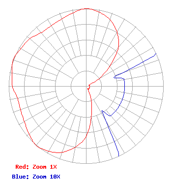 | ||||||||||||||||||
| Azimuth | Ratio | Azimuth | Ratio | Azimuth | Ratio | Azimuth | Ratio | ||||||||||||
| 0 | 1.000 | 10 | 0.970 | 20 | 0.910 | 30 | 0.800 | ||||||||||||
| 40 | 0.650 | 50 | 0.400 | 60 | 0.200 | 70 | 0.050 | ||||||||||||
| 80 | 0.050 | 90 | 0.050 | 100 | 0.050 | 110 | 0.050 | ||||||||||||
| 120 | 0.050 | 130 | 0.050 | 140 | 0.050 | 150 | 0.050 | ||||||||||||
| 160 | 0.200 | 170 | 0.400 | 180 | 0.650 | 190 | 0.800 | ||||||||||||
| 200 | 0.910 | 210 | 0.970 | 220 | 1.000 | 230 | 0.960 | ||||||||||||
| 240 | 0.920 | 250 | 0.900 | 260 | 0.900 | 270 | 0.950 | ||||||||||||
| 280 | 0.970 | 290 | 1.000 | 300 | 0.970 | 310 | 0.950 | ||||||||||||
| 320 | 0.900 | 330 | 0.900 | 340 | 0.920 | 350 | 0.960 | ||||||||||||
Structure Registration Number 1243907 Structure Type: TOWER Registered To: Rural Life Foundation, Inc. Structure Address: 1000 Feet East Of The Intersection Of Lonesome Pine Road And Sutton Hollow Road Savannah, TN County Name: Hardin County ASR Issued: 06/18/2004 Site Elevation: 222 m (728 ft.) Structure Height: 149 m (489 ft.) Height Overall: 150 m (492 ft.) Overall Height AMSL: 372 m (1220 ft.) FAA Determination: 02/09/2004 FAA Study #: 2004-ASO-734-OE FAA Circular #: 70/7460-1K Paint & Light FAA Chapters: 4, 6, 12 PRIOR STUDY 2002-ASO-3058-OE 35-12-23.3 N 88-03-32.1 W (NAD 83) 35-12-23.0 N 88-03-32.0 W (Converted to NAD 27) |
3573 Lonesome Pine Rd Savannah, TN 38372 Phone: 731-343-9741 Applicant | Title: President Date: 07/12/2021 Application Certifier RURAL LIFE FOUNDATIONS, INC. Rural Life Foundations, Inc. 3573 Lonesome Pine Rd Savannah, TN 38372 Applicant DANIEL PEEK Three Angels Broadcasting Network, Inc. Po Box 220 West Frankfort, IL 62896 ENGINEER DONALD MARTIN Law Office Of Donald E. Martin Falls Church, VA 22041 Attorney | |||||||||||||||||