
FCCInfo.com
A Service of Cavell, Mertz & Associates, Inc.
(855) FCC-INFO
|
|
WXON-LD from 07/13/2000 WXON-LD from 10/07/1996 |
|
|
||||||||||||||||
|
|
Status: License Application Accepted: 07/13/2021 License Expires: 10/01/2021 File Number: -0000152405 FCC Website Links: LMS Facility Details This Application Other WXON-LD Applications Including Superseded Applications Mailing Address Correspondence for WXON-LD Correspondence related to application -0000152405 Service Contour - Open Street Map or USGS Map (51 dBu) Service Contour - KML / Google Earth (51 dBu) Rabbit Ears Info Search for WXON-LD Site Location: 43-10-23.0 N 83-40-51.0 W (NAD 83) Site Location: 43-10-22.9 N 83-40-51.1 W (Converted to NAD 27) ERP: 15 kW Polarization: Horizontally polarized R/C AGL: 70 m (230 ft.) R/C AMSL: 308.1 m (1011 ft.) Emission Mask: Full Service Site Elevation: 238.1 m. (781 ft.) Height Overall*: 74.1 m (243 ft.) (* As Filed In This Application, may differ from ASR Data, Below.) Directional Antenna - Antenna Make/Model: DIELECTRIC TLP12-B Antenna ID: 1008428 Polarization: Horizontally polarized | ||||||||||||||||||
| Antenna Data for Antenna Id: 1008428 WXON-LD LD File: -0000152405 DIELECTRIC - TLP12-B Service: LD Standard Pattern: N Pattern and Field Values Include a 150° Clockwise Rotation | 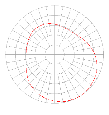 | ||||||||||||||||||
| Azimuth | Ratio | Azimuth | Ratio | Azimuth | Ratio | Azimuth | Ratio | ||||||||||||
| 0 | 0.620 | 10 | 0.600 | 20 | 0.580 | 30 | 0.580 | ||||||||||||
| 40 | 0.580 | 50 | 0.610 | 60 | 0.650 | 70 | 0.700 | ||||||||||||
| 80 | 0.760 | 90 | 0.820 | 100 | 0.870 | 110 | 0.920 | ||||||||||||
| 120 | 0.950 | 130 | 0.970 | 140 | 0.990 | 150 | 1.000 | ||||||||||||
| 160 | 0.990 | 170 | 0.980 | 180 | 0.950 | 190 | 0.920 | ||||||||||||
| 200 | 0.880 | 210 | 0.830 | 220 | 0.780 | 230 | 0.720 | ||||||||||||
| 240 | 0.660 | 250 | 0.620 | 260 | 0.590 | 270 | 0.580 | ||||||||||||
| 280 | 0.580 | 290 | 0.590 | 300 | 0.610 | 310 | 0.630 | ||||||||||||
| 320 | 0.650 | 330 | 0.650 | 340 | 0.650 | 350 | 0.640 | ||||||||||||
Structure Registration Number 1000541 Structure Type: LTOWER Registered To: Star Site LLC Structure Address: 11327 Lewis Road Pine Run, MI County Name: Genesee County ASR Issued: 11/29/2023 Date Built: 10/05/1954 Site Elevation: 238.1 m (781 ft.) Structure Height: 74 m (243 ft.) Height Overall: 74 m (243 ft.) Overall Height AMSL: 312.1 m (1024 ft.) FAA Determination: 11/14/2023 FAA Study #: 2023-AGL-21213-OE FAA Circular #: 70/7460-1M Paint & Light FAA Chapters: 4, 8, 15 PRIOR STUDY 2021-AGL-23884-OE 43-10-21.9 N 83-40-49.1 W (NAD 83) 43-10-21.8 N 83-40-49.2 W (Converted to NAD 27) |
978 Timberlynn Trail Lot 100 Sanford, MI 48657 Phone: 231-420-1325 Limited Liability Company | Title: Manager Date: 07/13/2021 Application Certifier Media Adventures, L.L.C. P & P Cable Holdings, L.l.c. 3450 Barber Road Bay City, MI 48706 Applicant Richard C Goetz R & L Media Systems 135 N Country Club Dr Hendersonville, TN 37075 Broadcast Consultant | |||||||||||||||||