
FCCInfo.com
A Service of Cavell, Mertz & Associates, Inc.
(855) FCC-INFO
|
|
KPTD-LP from 06/23/2004 |
|
|
||||||||||||||||
|
|
KPTD-LP is a channel sharing guest of KDTN, Denton, Texas Status: License Application Accepted: 07/13/2021 License Expires: 08/01/2022 File Number: -0000152446 FCC Website Links: LMS Facility Details This Application Other KPTD-LP Applications Including Superseded Applications Mailing Address Correspondence for KPTD-LP Correspondence related to application -0000152446 Service Contour - Open Street Map or USGS Map (51 dBu) Service Contour - KML / Google Earth (51 dBu) Rabbit Ears Info Search for KPTD-LP Site Location: 32-35-22.0 N 96-58-12.9 W (NAD 83) Site Location: 32-35-21.5 N 96-58-11.9 W (Converted to NAD 27) ERP: 415 kW Polarization: Elliptically polarized HAAT: 494.2 m (1621 ft.) Electrical Beam Tilt: 0.7 degrees R/C AGL: 462.7 m (1518 ft.) R/C AMSL: 715.6 m (2348 ft.) Emission Mask: Full Service Site Elevation: 252.9 m. (830 ft.) Height Overall*: 487.7 m (1600 ft.) (* As Filed In This Application, may differ from ASR Data, Below.) Directional Antenna - Antenna Make/Model: Dielectric TUM-AP-C4-14/48H-2-R-B Antenna ID: 1008433 Polarization: Elliptically polarized | ||||||||||||||||||
| Antenna Data for Antenna Id: 1008433 KPTD-LP LD File: -0000152446 Dielectric - TUM-AP-C4-14/48H-2-R-B Service: LD Standard Pattern: N | 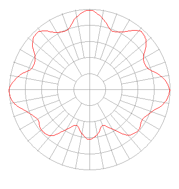 | ||||||||||||||||||
| Azimuth | Ratio | Azimuth | Ratio | Azimuth | Ratio | Azimuth | Ratio | ||||||||||||
| 0 | 0.984 | 10 | 0.903 | 20 | 0.782 | 30 | 0.827 | ||||||||||||
| 40 | 0.948 | 43 | 0.959 | 50 | 0.915 | 60 | 0.772 | ||||||||||||
| 70 | 0.770 | 80 | 0.910 | 90 | 0.994 | 91 | 0.996 | ||||||||||||
| 100 | 0.947 | 110 | 0.820 | 120 | 0.757 | 130 | 0.792 | ||||||||||||
| 140 | 0.743 | 150 | 0.566 | 160 | 0.479 | 170 | 0.568 | ||||||||||||
| 180 | 0.621 | 190 | 0.557 | 200 | 0.475 | 210 | 0.579 | ||||||||||||
| 220 | 0.750 | 230 | 0.782 | 240 | 0.744 | 250 | 0.820 | ||||||||||||
| 260 | 0.954 | 268 | 1.000 | 270 | 0.997 | 280 | 0.903 | ||||||||||||
| 290 | 0.763 | 300 | 0.779 | 310 | 0.920 | 316 | 0.955 | ||||||||||||
| 320 | 0.940 | 330 | 0.819 | 340 | 0.790 | 350 | 0.915 | ||||||||||||
Structure Registration Number 1055009 Structure Type: GTOWER Registered To: American Towers LLC Structure Address: 1360 W. Belt Line Rd. (075253) Cedar Hill, TX County Name: Dallas County ASR Issued: 12/19/2017 Date Built: 11/04/2008 Site Elevation: 252.9 m (830 ft.) Structure Height: 442.9 m (1453 ft.) Height Overall: 487.7 m (1600 ft.) Overall Height AMSL: 740.6 m (2430 ft.) FAA Determination: 12/13/2017 FAA Study #: 2017-ASW-18744-OE Paint & Light FAA Chapters: 1, 3, 10.1, 19.1, 21 Continue As Is OM&L = PAINT/RED LIGHTS 32-35-22.0 N 96-58-12.9 W (NAD 83) 32-35-21.5 N 96-58-11.9 W (Converted to NAD 27) |
3901 Highway 121 South Bedford, TX 76021 Phone: 817-571-1229 Applicant | Title: President Date: 07/13/2021 Application Certifier WORD OF GOD FELLOWSHIP, INC. Word Of God Fellowship, Inc. 3901 Highway 121 South Bedford, TX 76021 Applicant Ari Meltzer Wiley Rein Llp 1776 K Street Nw Washington, DC 20006 | |||||||||||||||||