
FCCInfo.com
A Service of Cavell, Mertz & Associates, Inc.
(855) FCC-INFO
|
|
|
|
|
||||||||||||||||
|
|
Status: License Application Accepted: 07/13/2021 License Expires: 04/01/2022 File Number: -0000152482 FCC Website Links: LMS Facility Details This Application Other K06HZ-D Applications Including Superseded Applications Mailing Address Correspondence for K06HZ-D Correspondence related to application -0000152482 Service Contour - Open Street Map or USGS Map (43 dBu) Service Contour - KML / Google Earth (43 dBu) Rabbit Ears Info Search for K06HZ-D Site Location: 38-52-28.3 N 107-39-42.6 W (NAD 83) Site Location: 38-52-28.4 N 107-39-40.4 W (Converted to NAD 27) ERP: 0.064 kW Polarization: Horizontally polarized R/C AGL: 31.8 m (104 ft.) R/C AMSL: 2121.2 m (6959 ft.) Emission Mask: Stringent Site Elevation: 2089.4 m. (6855 ft.) Height Overall*: 39.6 m (130 ft.) (* As Filed In This Application, may differ from ASR Data, Below.) Directional Antenna - Antenna Make/Model: Taco ODDK06HZ Antenna ID: 24254 Polarization: Horizontally polarized
| ||||||||||||||||||
| Antenna Data for Antenna Id: 24254 K06HZ-D LD File: -0000152482 Taco - ODDK06HZ Service: LD Standard Pattern: Y | 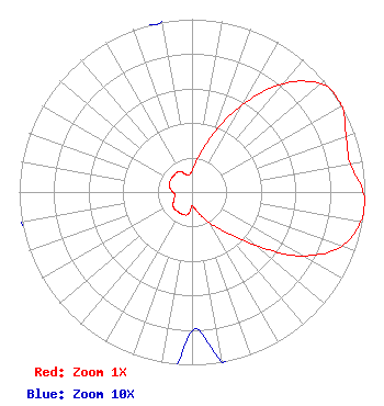 | ||||||||||||||||||
| Azimuth | Ratio | Azimuth | Ratio | Azimuth | Ratio | Azimuth | Ratio | ||||||||||||
| 0 | 0.125 | 10 | 0.200 | 20 | 0.360 | 30 | 0.580 | ||||||||||||
| 40 | 0.820 | 50 | 0.970 | 55 | 1.000 | 60 | 1.000 | ||||||||||||
| 70 | 0.950 | 80 | 0.930 | 90 | 0.990 | 95 | 1.000 | ||||||||||||
| 100 | 0.990 | 110 | 0.920 | 120 | 0.740 | 130 | 0.480 | ||||||||||||
| 140 | 0.300 | 150 | 0.210 | 160 | 0.140 | 170 | 0.100 | ||||||||||||
| 180 | 0.080 | 190 | 0.130 | 200 | 0.140 | 210 | 0.140 | ||||||||||||
| 220 | 0.140 | 230 | 0.139 | 240 | 0.125 | 250 | 0.110 | ||||||||||||
| 260 | 0.100 | 270 | 0.110 | 280 | 0.130 | 290 | 0.140 | ||||||||||||
| 300 | 0.143 | 310 | 0.143 | 320 | 0.143 | 330 | 0.139 | ||||||||||||
| 340 | 0.109 | 350 | 0.100 | ||||||||||||||||
Structure Registration Number 1239990 Structure Type: TOWER Registered To: North Fork Valley Public Radio,Inc Structure Address: On Wakefield Mesa Off Delta County Road 035 Paonia, CO County Name: Delta County ASR Issued: 08/20/2003 Date Built: 01/01/1990 Site Elevation: 2089.4 m (6855 ft.) Structure Height: 36.6 m (120 ft.) Height Overall: 39.6 m (130 ft.) Overall Height AMSL: 2129 m (6985 ft.) FAA Determination: 08/13/2003 FAA Study #: 2003-anm-1523-oe Paint & Light FAA Chapters: NONE Removed expiration date from determination. Scenario 1./jjs/case#635066 38-52-28.3 N 107-39-42.6 W (NAD 83) 38-52-28.4 N 107-39-40.4 W (Converted to NAD 27) |
545 E. John Carpenter Freeway Suite 700 Irving, TX 75062 Phone: 972-373-8800 Corporation | Title: General Counsel Date: 07/13/2021 Application Certifier Nexstar Media Inc. 545 E. John Carpenter Freeway Suite 700 Irving, TX 75062 Applicant Elizabeth Ryder Nexstar Media Inc. 545 E. John Carpenter Freeway Suite 700 Irving, TX 75062 General Counsel | |||||||||||||||||