
FCCInfo.com
A Service of Cavell, Mertz & Associates, Inc.
(855) FCC-INFO
|
|
|
|
|
||||||||||||||||
|
|
Status: License Application Accepted: 07/13/2021 License Expires: 04/01/2022 File Number: -0000152485 FCC Website Links: LMS Facility Details This Application Other K13ML-D Applications Including Superseded Applications Mailing Address Correspondence for K13ML-D Correspondence related to application -0000152485 Service Contour - Open Street Map or USGS Map (48 dBu) Service Contour - KML / Google Earth (48 dBu) Rabbit Ears Info Search for K13ML-D Site Location: 38-42-40.9 N 107-36-23.0 W (NAD 83) Site Location: 38-42-40.9 N 107-36-20.8 W (Converted to NAD 27) ERP: 0.268 kW Polarization: Horizontally polarized R/C AGL: 9 m (30 ft.) R/C AMSL: 2271 m (7451 ft.) Emission Mask: Full Service Site Elevation: 2262 m. (7421 ft.) Height Overall*: 10.7 m (35 ft.) (* As Filed In This Application, may differ from ASR Data, Below.) Directional Antenna - Antenna Make/Model: Scala HDCA-10 ARRAY Antenna ID: 111435 Polarization: Horizontally polarized
| ||||||||||||||||||
| Antenna Data for Antenna Id: 111435 K13ML-D LD File: -0000152485 Scala - HDCA-10 ARRAY Service: LD Standard Pattern: Y | 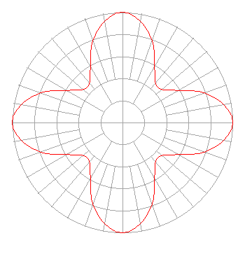 | ||||||||||||||||||
| Azimuth | Ratio | Azimuth | Ratio | Azimuth | Ratio | Azimuth | Ratio | ||||||||||||
| 0 | 1.000 | 10 | 0.932 | 20 | 0.786 | 30 | 0.582 | ||||||||||||
| 40 | 0.465 | 50 | 0.465 | 60 | 0.582 | 70 | 0.786 | ||||||||||||
| 80 | 0.932 | 90 | 1.000 | 100 | 0.932 | 110 | 0.786 | ||||||||||||
| 120 | 0.582 | 130 | 0.465 | 140 | 0.465 | 150 | 0.582 | ||||||||||||
| 160 | 0.786 | 170 | 0.932 | 180 | 1.000 | 190 | 0.932 | ||||||||||||
| 200 | 0.786 | 210 | 0.582 | 220 | 0.465 | 230 | 0.465 | ||||||||||||
| 240 | 0.582 | 250 | 0.786 | 260 | 0.932 | 270 | 1.000 | ||||||||||||
| 280 | 0.932 | 290 | 0.786 | 300 | 0.582 | 310 | 0.465 | ||||||||||||
| 320 | 0.465 | 330 | 0.582 | 340 | 0.786 | 350 | 0.932 | ||||||||||||
Structure Registration Number 1318919 Structure Type: LTOWER Registered To: Nexstar Media Inc. Structure Address: Youngs Peak, Colorado Crawford, CO County Name: Delta County ASR Issued: 05/28/2021 Date Built: 05/29/2021 Site Elevation: 2262 m (7421 ft.) Structure Height: 10.7 m (35 ft.) Height Overall: 10.7 m (35 ft.) Overall Height AMSL: 2272.7 m (7456 ft.) FAA Determination: 03/01/2021 FAA Study #: 2021-ANM-501-OE Paint & Light FAA Chapters: NONE 38-42-40.9 N 107-36-23.0 W (NAD 83) 38-42-40.9 N 107-36-20.8 W (Converted to NAD 27) |
545 E. John Carpenter Freeway Suite 700 Irving, TX 75062 Phone: 972-373-8800 Corporation | Title: General Counsel Date: 07/13/2021 Application Certifier Nexstar Media Inc. 545 E. John Carpenter Freeway Suite 700 Irving, TX 75062 Applicant Greg Best Greg Best Consulting, Inc 16100 Outlook Ave Stilwell, KS 66085 Consulting Engineer Elizabeth Ryder Nexstar Media Inc. 545 E. John Carpenter Freeway Suite 700 Irving, TX 75062 General Counsel | |||||||||||||||||