
FCCInfo.com
A Service of Cavell, Mertz & Associates, Inc.
(855) FCC-INFO
|
|
WALE-LD from 06/14/2013 |
|
|
||||||||||||||||
|
|
Status: License Application Accepted: 07/14/2021 License Expires: 04/02/2029 File Number: -0000152783 FCC Website Links: LMS Facility Details This Application Other WALE-LD Applications Including Superseded Applications Mailing Address Correspondence for WALE-LD Correspondence related to application -0000152783 Service Contour - Open Street Map or USGS Map (51 dBu) Service Contour - KML / Google Earth (51 dBu) Rabbit Ears Info Search for WALE-LD Site Location: 32-20-07.0 N 86-17-16.0 W (NAD 83) Site Location: 32-20-06.5 N 86-17-16.1 W (Converted to NAD 27) ERP: 15 kW Polarization: Horizontally polarized Electrical Beam Tilt: 1.5 degrees R/C AGL: 237.2 m (778 ft.) R/C AMSL: 300 m (984 ft.) Emission Mask: Full Service Site Elevation: 62.8 m. (206 ft.) Height Overall*: 241.7 m (793 ft.) (* As Filed In This Application, may differ from ASR Data, Below.) Directional Antenna - Antenna Make/Model: DIELECTRIC TLP-12-S254 Antenna ID: 1003382 Polarization: Horizontally polarized | ||||||||||||||||||
| Antenna Data for Antenna Id: 1003382 WALE-LD LD File: -0000152783 DIELECTRIC - TLP-12-S254 Service: LD Standard Pattern: N | 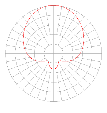 | ||||||||||||||||||
| Azimuth | Ratio | Azimuth | Ratio | Azimuth | Ratio | Azimuth | Ratio | ||||||||||||
| 0 | 1.000 | 10 | 0.989 | 20 | 0.956 | 30 | 0.907 | ||||||||||||
| 40 | 0.848 | 50 | 0.785 | 60 | 0.723 | 70 | 0.667 | ||||||||||||
| 80 | 0.612 | 90 | 0.554 | 100 | 0.489 | 110 | 0.413 | ||||||||||||
| 120 | 0.328 | 130 | 0.247 | 140 | 0.200 | 150 | 0.214 | ||||||||||||
| 160 | 0.262 | 170 | 0.306 | 180 | 0.322 | 190 | 0.306 | ||||||||||||
| 200 | 0.262 | 210 | 0.214 | 220 | 0.200 | 230 | 0.247 | ||||||||||||
| 240 | 0.328 | 250 | 0.413 | 260 | 0.489 | 270 | 0.554 | ||||||||||||
| 280 | 0.612 | 290 | 0.667 | 300 | 0.723 | 310 | 0.785 | ||||||||||||
| 320 | 0.848 | 330 | 0.907 | 340 | 0.956 | 350 | 0.989 | ||||||||||||
Structure Registration Number 1038437 Structure Type: 2TOWER Registered To: WOODS COMMUNICATIONS CORP DBA = WCOV TV Structure Address: 1 Wcov Ave Montgomery, AL County Name: Montgomery County ASR Issued: 02/26/1998 Date Built: 06/01/1997 Site Elevation: 62.8 m (206 ft.) Structure Height: 241.7 m (793 ft.) Height Overall: 241.7 m (793 ft.) Overall Height AMSL: 304.5 m (999 ft.) FAA Determination: 06/05/1996 FAA Study #: 96-ASO-1622-OE FAA Circular #: 70/7460-1J Paint & Light FAA Chapters: 3, 4, 5, 13 32-20-07.0 N 86-17-16.0 W (NAD 83) 32-20-06.5 N 86-17-16.1 W (Converted to NAD 27) |
1925 Century Park East 10th Floor Los Angeles, CA 90067 Phone: 310-277-3500 Limited Liability Company | Title: President Date: 07/14/2021 Application Certifier Woods Communications Corporation One Wcov Avenue Montgomery, AL 36111 Applicant Joseph M. Davis, P.E. Chesapeake Rf Consultants, Llc 207 Old Dominion Road Yorktown, VA 23692 Consulting Engineer AARON P SHAINIS Shainis & Peltzman, Chartered 1850 M. St, Nw Suite 240 Washington, DC 20036 | |||||||||||||||||