
FCCInfo.com
A Service of Cavell, Mertz & Associates, Inc.
(855) FCC-INFO
|
|
K28QF-D from 07/29/2021 K28QF-D from 02/22/2011 |
|
|
||||||||||||||||
|
|
Status: License Application Accepted: 07/27/2021 License Expires: 08/01/2022 File Number: -0000154204 FCC Website Links: LMS Facility Details This Application Other KAQI-LD Applications Including Superseded Applications Mailing Address Correspondence for KAQI-LD Correspondence related to application -0000154204 Service Contour - Open Street Map or USGS Map (51 dBu) Service Contour - KML / Google Earth (51 dBu) Rabbit Ears Info Search for KAQI-LD Site Location: 34-01-58.0 N 96-48-01.0 W (NAD 83) Site Location: 34-01-57.6 N 96-47-60.0 W (Converted to NAD 27) ERP: 15 kW Polarization: Elliptically polarized Electrical Beam Tilt: 1.0 degree R/C AGL: 457.2 m (1500 ft.) R/C AMSL: 728.4 m (2390 ft.) Emission Mask: Full Service Site Elevation: 271.2 m. (890 ft.) Height Overall*: 516.3 m (1694 ft.) (* As Filed In This Application, may differ from ASR Data, Below.) Directional Antenna - Antenna Make/Model: Dielectric TLP-12H/VP Antenna ID: 1008492 Polarization: Elliptically polarized | ||||||||||||||||||
| Antenna Data for Antenna Id: 1008492 KAQI-LD LD File: -0000154204 Dielectric - TLP-12H/VP Service: LD Standard Pattern: N Pattern and Field Values Include a 90° Clockwise Rotation | 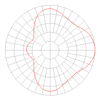 | ||||||||||||||||||
| Azimuth | Ratio | Azimuth | Ratio | Azimuth | Ratio | Azimuth | Ratio | ||||||||||||
| 0 | 0.918 | 10 | 0.885 | 20 | 0.834 | 30 | 0.793 | ||||||||||||
| 40 | 0.777 | 50 | 0.816 | 60 | 0.885 | 70 | 0.949 | ||||||||||||
| 80 | 0.984 | 90 | 1.000 | 100 | 0.977 | 110 | 0.917 | ||||||||||||
| 120 | 0.842 | 130 | 0.776 | 140 | 0.768 | 150 | 0.779 | ||||||||||||
| 160 | 0.828 | 170 | 0.885 | 180 | 0.911 | 190 | 0.880 | ||||||||||||
| 200 | 0.788 | 210 | 0.673 | 220 | 0.560 | 230 | 0.467 | ||||||||||||
| 240 | 0.430 | 250 | 0.452 | 260 | 0.495 | 270 | 0.521 | ||||||||||||
| 280 | 0.511 | 290 | 0.477 | 300 | 0.446 | 310 | 0.468 | ||||||||||||
| 320 | 0.560 | 330 | 0.688 | 340 | 0.810 | 350 | 0.891 | ||||||||||||
Structure Registration Number 1011273 Structure Type: TOWER Registered To: Gray Media Group, Inc. Structure Address: Hwy 99 8.05 Km Ssw Madill, OK County Name: Marshall County ASR Issued: 09/09/2020 Date Built: 02/01/1984 Site Elevation: 271.2 m (890 ft.) Structure Height: 487.6 m (1600 ft.) Height Overall: 516.3 m (1694 ft.) Overall Height AMSL: 787.5 m (2584 ft.) Paint & Light FAA Chapters: A1, B, F, H 34-01-58.0 N 96-48-01.0 W (NAD 83) 34-01-57.6 N 96-47-60.0 W (Converted to NAD 27) |
4370 Peachtree Road, Ne Atlanta, GA 30319 Phone: 202-750-1585 Limited Liability Company | Title: Assistant Secretary Date: 07/27/2021 Application Certifier Gray Television Licensee, Llc 4370 Peachtree Road, Ne Atlanta, GA 30319 Applicant Joseph M. Davis, P.E. Chesapeake Rf Consultants, Llc 207 Old Dominion Road Yorktown, VA 23692 Consulting Engineer Joan Stewart Wiley Rein Llp 1776 K Street, Nw Washington, DC 20006 | |||||||||||||||||