
FCCInfo.com
A Service of Cavell, Mertz & Associates, Inc.
(855) FCC-INFO
|
|
K35NZ-D from 07/24/2012 |
|
|
||||||||||||||||
|
|
Status: License Application Accepted: 07/30/2021 License Expires: 02/01/2023 File Number: -0000154784 FCC Website Links: LMS Facility Details This Application Other K35NZ-D Applications Including Superseded Applications Mailing Address Correspondence for K35NZ-D Correspondence related to application -0000154784 Service Contour - Open Street Map or USGS Map (51 dBu) Service Contour - KML / Google Earth (51 dBu) Rabbit Ears Info Search for K35NZ-D Site Location: 60-00-36.8 N 151-42-46.0 W (NAD 83) Site Location: 60-00-39.0 N 151-42-38.1 W (Converted to NAD 27) ERP: 15 kW Polarization: Horizontally polarized R/C AGL: 61 m (200 ft.) R/C AMSL: 132.9 m (436 ft.) Emission Mask: Simple Site Elevation: 71.9 m. (236 ft.) Height Overall*: 93.6 m (307 ft.) (* As Filed In This Application, may differ from ASR Data, Below.) Directional Antenna - Antenna Make/Model: DIELECTRIC TLP-16TLP-J Antenna ID: 1008509 Polarization: Horizontally polarized
| ||||||||||||||||||
| Antenna Data for Antenna Id: 1008509 K35NZ-D LD File: -0000154784 DIELECTRIC - TLP-16TLP-J Service: LD Standard Pattern: N | 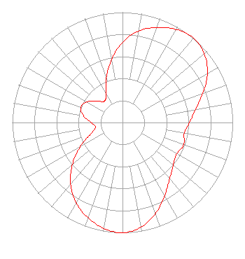 | ||||||||||||||||||
| Azimuth | Ratio | Azimuth | Ratio | Azimuth | Ratio | Azimuth | Ratio | ||||||||||||
| 0 | 0.728 | 10 | 0.844 | 20 | 0.917 | 30 | 0.975 | ||||||||||||
| 40 | 1.000 | 50 | 0.969 | 60 | 0.890 | 70 | 0.775 | ||||||||||||
| 80 | 0.673 | 90 | 0.608 | 100 | 0.569 | 110 | 0.591 | ||||||||||||
| 120 | 0.568 | 130 | 0.601 | 140 | 0.666 | 150 | 0.764 | ||||||||||||
| 160 | 0.878 | 170 | 0.964 | 180 | 1.000 | 190 | 0.975 | ||||||||||||
| 200 | 0.918 | 210 | 0.842 | 220 | 0.731 | 230 | 0.594 | ||||||||||||
| 240 | 0.444 | 250 | 0.309 | 260 | 0.250 | 270 | 0.284 | ||||||||||||
| 280 | 0.361 | 290 | 0.402 | 300 | 0.374 | 310 | 0.299 | ||||||||||||
| 320 | 0.253 | 330 | 0.296 | 340 | 0.427 | 350 | 0.579 | ||||||||||||
Structure Registration Number 1003111 Structure Type: LTOWER Registered To: State of Alaska Structure Address: W Of Sterling Hwy At Mile 138 Ninilchik, AK County Name: Kenai Peninsula Borough ASR Issued: 09/10/2015 Date Built: 04/13/2015 Site Elevation: 71.9 m (236 ft.) Structure Height: 91.5 m (300 ft.) Height Overall: 93.6 m (307 ft.) Overall Height AMSL: 165.5 m (543 ft.) FAA Determination: 03/26/2015 FAA Study #: 2015-AAL-77-OE FAA Circular #: 70/7460-1K Paint & Light FAA Chapters: 4, 8, 12 PRIOR STUDY 2008-AAL-585-OE 60-00-36.8 N 151-42-46.0 W (NAD 83) 60-00-39.0 N 151-42-38.1 W (Converted to NAD 27) |
8620 Cold Springs Road Raleigh, NC 27615 Phone: 919-414-9288 Limited Liability Company | Title: Manager Date: 07/30/2021 Application Certifier KYUR LICENSE LLC Kyur License Llc 8620 Cold Springs Road Raleigh, NC 27615 Applicant Carl E Gluck, Consultant Carl T Jones Corp 7901 Yarnwood Court Springfield, VA 22153 Technical Consultant Daniel Kirkpatrick, Esq. Baker & Hostetler Llp 1050 Connecticut Ave., Nw Suite 1100 Washington, DC 20036 Legal Counsel | |||||||||||||||||