
FCCInfo.com
A Service of Cavell, Mertz & Associates, Inc.
(855) FCC-INFO
|
|
W29FR-D from 07/11/2012 |
|
|
||||||||||||||||
|
|
Status: License Application Accepted: 07/28/2021 License Expires: 08/01/2029 File Number: -0000154284 FCC Website Links: LMS Facility Details This Application Other W29FR-D Applications Including Superseded Applications Mailing Address Correspondence for W29FR-D Correspondence related to application -0000154284 Service Contour - Open Street Map or USGS Map (51 dBu) Service Contour - KML / Google Earth (51 dBu) Rabbit Ears Info Search for W29FR-D Site Location: 36-09-13.0 N 86-22-46.0 W (NAD 83) Site Location: 36-09-12.8 N 86-22-46.0 W (Converted to NAD 27) ERP: 15 kW Polarization: Horizontally polarized R/C AGL: 80 m (262 ft.) R/C AMSL: 351 m (1152 ft.) Emission Mask: Full Service Site Elevation: 271 m. (889 ft.) Height Overall*: 85 m (279 ft.) (* As Filed In This Application, may differ from ASR Data, Below.) Directional Antenna - Antenna Make/Model: Propagation System Inc PSILPD12BA Antenna ID: 111377 Polarization: Horizontally polarized
| ||||||||||||||||||
| Antenna Data for Antenna Id: 111377 W29FR-D LD File: -0000154284 Propagation System Inc - PSILPD12BA Service: LD Standard Pattern: Y Pattern and Field Values Include a 120° Clockwise Rotation | 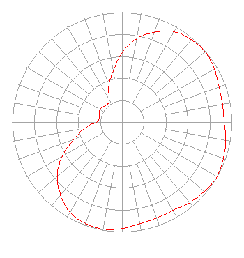 | ||||||||||||||||||
| Azimuth | Ratio | Azimuth | Ratio | Azimuth | Ratio | Azimuth | Ratio | ||||||||||||
| 0 | 0.630 | 10 | 0.770 | 20 | 0.870 | 30 | 0.950 | ||||||||||||
| 40 | 0.980 | 50 | 0.990 | 60 | 0.970 | 70 | 0.940 | ||||||||||||
| 80 | 0.930 | 90 | 0.930 | 100 | 0.960 | 110 | 0.980 | ||||||||||||
| 120 | 1.000 | 130 | 0.980 | 140 | 0.960 | 150 | 0.930 | ||||||||||||
| 160 | 0.930 | 170 | 0.940 | 180 | 0.970 | 190 | 0.990 | ||||||||||||
| 200 | 0.980 | 210 | 0.950 | 220 | 0.870 | 230 | 0.770 | ||||||||||||
| 240 | 0.630 | 250 | 0.470 | 260 | 0.350 | 270 | 0.230 | ||||||||||||
| 280 | 0.210 | 290 | 0.220 | 300 | 0.230 | 310 | 0.220 | ||||||||||||
| 320 | 0.210 | 330 | 0.230 | 340 | 0.350 | 350 | 0.470 | ||||||||||||
Structure Registration Number 1044881 Structure Type: Registered To: Subcarrier Communications Inc Structure Address: On Franklin Pike 4.3 Mi S Lebanon, TN County Name: Wilson County ASR Issued: 06/10/2022 Date Built: 01/01/1986 Site Elevation: 271 m (889 ft.) Structure Height: 84 m (276 ft.) Height Overall: 85 m (279 ft.) Overall Height AMSL: 356 m (1168 ft.) Paint & Light FAA Chapters: B, H 36-09-13.0 N 86-22-46.0 W (NAD 83) 36-09-12.8 N 86-22-46.0 W (Converted to NAD 27) |
4370 Peachtree Road, Ne Atlanta, GA 30319 Phone: 202-750-1585 Limited Liability Company | Title: Manager Date: 07/28/2021 Application Certifier Lowcountry 34 Media, Llc 14 Tuxedo Drive Beaufort, SC 29907 Applicant Darryl K DeLawder Delawder Communications, Inc. P.o. Box 1095 Ashburn, VA 20146 President Davina Sashkin, Esq Baker & Hostetler Llp 1050 Connecticut Avenue, Nw Suite 1100 Washington, DC 20036 | |||||||||||||||||