
FCCInfo.com
A Service of Cavell, Mertz & Associates, Inc.
(855) FCC-INFO
|
|
KRFT-LD from 09/22/2010 KRFT-LD from 01/08/1993 KRFT-LD from 01/06/1993 |
|
|
||||||||||||||||
|
|
Status: License Application Accepted: 08/04/2021 License Expires: 02/01/2022 File Number: -0000156037 FCC Website Links: LMS Facility Details This Application Other KRFT-LD Applications Including Superseded Applications Mailing Address Correspondence for KRFT-LD Correspondence related to application -0000156037 Service Contour - Open Street Map or USGS Map (51 dBu) Service Contour - KML / Google Earth (51 dBu) Rabbit Ears Info Search for KRFT-LD Site Location: 37-14-23.0 N 93-17-08.0 W (NAD 83) Site Location: 37-14-22.8 N 93-17-07.3 W (Converted to NAD 27) ERP: 15 kW Polarization: Horizontally polarized Electrical Beam Tilt: 0.25 degrees R/C AGL: 83.8 m (275 ft.) R/C AMSL: 473.8 m (1554 ft.) Emission Mask: Full Service Site Elevation: 390 m. (1280 ft.) Height Overall*: 151.8 m (498 ft.) (* As Filed In This Application, may differ from ASR Data, Below.) Directional Antenna - Antenna Make/Model: Electronics Research Inc. ALP8L1-HSOC-21 Antenna ID: 1008524 Polarization: Horizontally polarized | ||||||||||||||||||
| Antenna Data for Antenna Id: 1008524 KRFT-LD LD File: -0000156037 Electronics Research Inc. - ALP8L1-HSOC-21 Service: LD Standard Pattern: N Pattern and Field Values Include a 110° Clockwise Rotation | 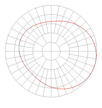 | ||||||||||||||||||
| Azimuth | Ratio | Azimuth | Ratio | Azimuth | Ratio | Azimuth | Ratio | ||||||||||||
| 0 | 0.645 | 10 | 0.663 | 20 | 0.694 | 30 | 0.734 | ||||||||||||
| 40 | 0.781 | 50 | 0.829 | 60 | 0.876 | 70 | 0.918 | ||||||||||||
| 80 | 0.953 | 90 | 0.979 | 100 | 0.996 | 110 | 1.000 | ||||||||||||
| 120 | 0.996 | 130 | 0.979 | 140 | 0.953 | 150 | 0.918 | ||||||||||||
| 160 | 0.876 | 170 | 0.829 | 180 | 0.781 | 190 | 0.734 | ||||||||||||
| 200 | 0.694 | 210 | 0.663 | 220 | 0.645 | 230 | 0.641 | ||||||||||||
| 240 | 0.647 | 250 | 0.661 | 260 | 0.679 | 270 | 0.694 | ||||||||||||
| 280 | 0.705 | 290 | 0.709 | 300 | 0.705 | 310 | 0.694 | ||||||||||||
| 320 | 0.679 | 330 | 0.661 | 340 | 0.647 | 350 | 0.641 | ||||||||||||
Structure Registration Number 1005680 Structure Type: TOWER Registered To: BAPTIST BIBLE COLLEGE INC Structure Address: 628 E Kearney St Springfield, MO County Name: Greene County ASR Issued: 11/27/1996 Date Built: 02/01/1969 Site Elevation: 390 m (1280 ft.) Structure Height: 151.8 m (498 ft.) Height Overall: 151.8 m (498 ft.) Overall Height AMSL: 541.8 m (1778 ft.) FAA Determination: 07/18/1990 FAA Study #: 73-CE-136-OE Paint & Light FAA Chapters: 1, 3, 4, 13, 21 RED LIGHTS/PAINT 37-14-23.0 N 93-17-08.0 W (NAD 83) 37-14-22.8 N 93-17-07.3 W (Converted to NAD 27) |
305 Riverside Drive Hinton, WV 25951 Phone: 417-849-5011 Limited Liability Company | Title: Manager/member Date: 08/04/2021 Application Certifier SPRINGFIELD TV, LLC Springfield Tv, Llc 1800 Northgate Blvd Suite A-10 Sarasota, FL 34234 Applicant CLARENCE M BEVERAGE Communications Technologies, Inc. 23 Binsted Drive Medford, NJ 08055 BROADCAST ENGINEERING CONSULTANT T. MICHAEL CRAFT Craft Broadcasting, Llc 408 Riverside Drive Hinton, WV 25951 OWNER/ENGINEER ANTHONY T LEPORE, ESQ Radiotvlaw Associates, Llc 4101 Albemarle St Nw #324 Washington, DC 20016 | |||||||||||||||||