
FCCInfo.com
A Service of Cavell, Mertz & Associates, Inc.
(855) FCC-INFO
|
|
KVDO-LD from 10/04/2007 |
Virtual Channel 3 |
|
|||||||||||||||||
|
|
Status: License Application Accepted: 08/16/2021 License Expires: 02/01/2023 File Number: -0000157484 FCC Website Links: LMS Facility Details This Application Other KVDO-LD Applications Including Superseded Applications Mailing Address Correspondence for KVDO-LD Correspondence related to application -0000157484 Service Contour - Open Street Map or USGS Map (51 dBu) Service Contour - KML / Google Earth (51 dBu) Rabbit Ears Info Search for KVDO-LD Site Location: 44-30-19.0 N 122-57-42.0 W (NAD 83) Site Location: 44-30-19.6 N 122-57-37.7 W (Converted to NAD 27) ERP: 2.5 kW Polarization: Horizontally polarized R/C AGL: 20 m (66 ft.) R/C AMSL: 435.1 m (1427 ft.) Emission Mask: Full Service Site Elevation: 415.1 m. (1362 ft.) Height Overall*: 62.1 m (204 ft.) (* As Filed In This Application, may differ from ASR Data, Below.) Directional Antenna - Antenna Make/Model: Scala 4DR-4S Antenna ID: 20748 Polarization: Horizontally polarized
| |||||||||||||||||||
| Antenna Data for Antenna Id: 20748 KVDO-LD LD File: -0000157484 Scala - 4DR-4S Service: LD Standard Pattern: Y Pattern and Field Values Include a 310° Clockwise Rotation | 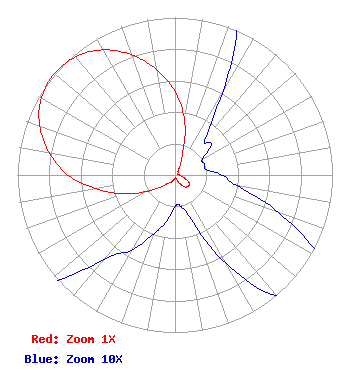 | |||||||||||||||||||
| Azimuth | Ratio | Azimuth | Ratio | Azimuth | Ratio | Azimuth | Ratio | |||||||||||||
| 0 | 0.530 | 10 | 0.350 | 20 | 0.140 | 30 | 0.060 | |||||||||||||
| 40 | 0.030 | 50 | 0.030 | 60 | 0.020 | 70 | 0.020 | |||||||||||||
| 80 | 0.020 | 90 | 0.030 | 100 | 0.040 | 110 | 0.070 | |||||||||||||
| 120 | 0.105 | 130 | 0.110 | 140 | 0.100 | 150 | 0.065 | |||||||||||||
| 160 | 0.030 | 170 | 0.020 | 180 | 0.020 | 190 | 0.030 | |||||||||||||
| 200 | 0.040 | 210 | 0.055 | 220 | 0.070 | 230 | 0.115 | |||||||||||||
| 240 | 0.210 | 250 | 0.350 | 260 | 0.510 | 270 | 0.680 | |||||||||||||
| 280 | 0.810 | 290 | 0.915 | 300 | 0.980 | 310 | 1.000 | |||||||||||||
| 320 | 0.980 | 330 | 0.917 | 340 | 0.813 | 350 | 0.680 | |||||||||||||
Structure Registration Number 1048264 Structure Type: TOWER Registered To: Consumers Power Inc Structure Address: Peterson Butte Lebanon, OR County Name: Linn County ASR Issued: 02/09/2022 Date Built: 07/27/1992 Site Elevation: 415.1 m (1362 ft.) Structure Height: 62.1 m (204 ft.) Height Overall: 62.1 m (204 ft.) Overall Height AMSL: 477.2 m (1566 ft.) FAA Determination: 07/27/1992 FAA Study #: 92-ANM-0523-OE FAA Circular #: 70/7460-1H Paint & Light FAA Chapters: 4, 5, 13 44-30-19.0 N 122-57-42.0 W (NAD 83) 44-30-19.6 N 122-57-37.7 W (Converted to NAD 27) |
Dallas, OR 97338 Phone: 503-623-7795 Individual | Title: Owner Date: 08/16/2021 Application Certifier KENNETH E. LEWETAG 17980 Brown Rd. Dallas, OR 97338 Applicant KENNETH E. LEWETAG Kenneth E. Lewetag 17980 Brown Rd Dallas, OR 97338 OWNER | ||||||||||||||||||