
FCCInfo.com
A Service of Cavell, Mertz & Associates, Inc.
(855) FCC-INFO
|
|
WXLV-TV from 06/08/1984 WXLV-TV from 10/20/1980 |
Virtual Channel 45 |  |
|
||||||||||||||||||
|
|
Repacking Information: No changes Status: License Application Accepted: 09/03/2021 License Expires: 12/01/2020 File Number: -0000158591 FCC Website Links: LMS Facility Details This Application Other WXLV-TV Applications Including Superseded Applications Mailing Address Correspondence for WXLV-TV Correspondence related to application -0000158591 Service Contour - Open Street Map or USGS Map (41 dBu) Service Contour - KML / Google Earth (41 dBu) Public Inspection Files History Cards for WXLV-TV Rabbit Ears Info Search for WXLV-TV Site Location: 35-52-02.6 N 79-49-25.4 W (NAD 83) Site Location: 35-52-02.1 N 79-49-26.3 W (Converted to NAD 27) ERP: 990 kW Polarization: Horizontally polarized HAAT: 576 m (1890 ft.) Electrical Beam Tilt: 0.75 degrees R/C AGL: 571 m (1873 ft.) R/C AMSL: 796.3 m (2613 ft.) Site Elevation: 225.3 m. (739 ft.) Height Overall*: 582.3 m (1910 ft.) (* As Filed In This Application, may differ from ASR Data, Below.) Directional Antenna - Antenna Make/Model: DIELECTRIC TFU-26DSC-R S190 Antenna ID: 105146 Polarization: Horizontally polarized | |||||||||||||||||||||
| Antenna Data for Antenna Id: 105146 WXLV-TV DT File: -0000158591 DIELECTRIC - TFU-26DSC-R S190 Service: DT Standard Pattern: Y | 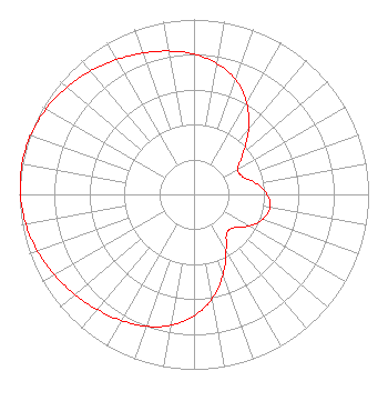 | |||||||||||||||||||||
| Azimuth | Ratio | Azimuth | Ratio | Azimuth | Ratio | Azimuth | Ratio | |||||||||||||||
| 0 | 0.802 | 10 | 0.760 | 20 | 0.696 | 30 | 0.603 | |||||||||||||||
| 40 | 0.487 | 50 | 0.368 | 60 | 0.290 | 70 | 0.297 | |||||||||||||||
| 80 | 0.361 | 90 | 0.419 | 100 | 0.442 | 110 | 0.419 | |||||||||||||||
| 120 | 0.361 | 130 | 0.297 | 140 | 0.290 | 150 | 0.368 | |||||||||||||||
| 160 | 0.487 | 170 | 0.603 | 180 | 0.696 | 190 | 0.760 | |||||||||||||||
| 200 | 0.802 | 210 | 0.832 | 220 | 0.860 | 230 | 0.890 | |||||||||||||||
| 240 | 0.922 | 250 | 0.953 | 260 | 0.978 | 270 | 0.994 | |||||||||||||||
| 280 | 1.000 | 290 | 0.994 | 300 | 0.978 | 310 | 0.953 | |||||||||||||||
| 320 | 0.922 | 330 | 0.890 | 340 | 0.860 | 350 | 0.832 | |||||||||||||||
Structure Registration Number 1061305 Structure Type: GTOWER Registered To: American Towers LLC Structure Address: 7493 Walker Mill Road/ Btg (randelman) Site#023618 Randleman /27317, NC County Name: Randolph County ASR Issued: 10/12/2023 Date Built: 02/05/2004 Site Elevation: 225.3 m (739 ft.) Structure Height: 535 m (1755 ft.) Height Overall: 582.3 m (1910 ft.) Overall Height AMSL: 807.6 m (2650 ft.) FAA Determination: 09/28/2023 FAA Study #: 2022-ASO-44787-OE FAA Circular #: 70/7460-1M Paint & Light FAA Chapters: 4, 9, 15 PRIOR STUDY 1997-ASO-715-OE 35-52-02.6 N 79-49-25.4 W (NAD 83) 35-52-02.1 N 79-49-26.3 W (Converted to NAD 27) |
Pillsbury Winthrop Shaw Pittman Llp 1200 Seventeenth Street, Nw Washington, DC 20036 Phone: 202-663-8195 Limited Liability Company | Title: President And Ceo Date: 09/03/2021 Application Certifier WXLV Licensee, LLC Wxlv Licensee, Llc Pillsbury Winthrop Shaw Pittman Llp 1200 Seventeenth Street, Nw Washington, DC 20036 Applicant Miles S. Mason, Esq Pillsbury Winthrop Shaw Pittman Llp 1200 Seventeenth Street, Nw Washington, DC 20036 | ||||||||||||||||||||
| ||||||||||||||||||||||
