
FCCInfo.com
A Service of Cavell, Mertz & Associates, Inc.
(855) FCC-INFO
|
|
W14EQ-D from 07/26/2004 |
|
|
||||||||||||||||
|
|
Status: License Application Accepted: 08/27/2021 License Expires: 06/01/2021 File Number: -0000158096 FCC Website Links: LMS Facility Details This Application Other W14EQ-D Applications Including Superseded Applications Mailing Address Correspondence for W14EQ-D Correspondence related to application -0000158096 Service Contour - Open Street Map or USGS Map (51 dBu) Service Contour - KML / Google Earth (51 dBu) Rabbit Ears Info Search for W14EQ-D Site Location: 34-09-20.7 N 88-38-34.2 W (NAD 83) Site Location: 34-09-20.3 N 88-38-34.0 W (Converted to NAD 27) ERP: 0.005 kW Polarization: Horizontally polarized R/C AGL: 10 m (33 ft.) R/C AMSL: 92.9 m (305 ft.) Emission Mask: Full Service Site Elevation: 82.9 m. (272 ft.) Height Overall*: 80.7 m (265 ft.) (* As Filed In This Application, may differ from ASR Data, Below.) Directional Antenna - Antenna Make/Model: Scala CL-1469 Antenna ID: 20778 Polarization: Horizontally polarized | ||||||||||||||||||
| Antenna Data for Antenna Id: 20778 W14EQ-D LD File: -0000158096 Scala - CL-1469 Service: LD Standard Pattern: Y Pattern and Field Values Include a 335° Clockwise Rotation | 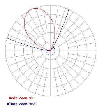 | ||||||||||||||||||
| Azimuth | Ratio | Azimuth | Ratio | Azimuth | Ratio | Azimuth | Ratio | ||||||||||||
| 5 | 0.622 | 15 | 0.361 | 25 | 0.086 | 35 | 0.010 | ||||||||||||
| 45 | 0.010 | 55 | 0.010 | 65 | 0.010 | 75 | 0.010 | ||||||||||||
| 85 | 0.010 | 95 | 0.010 | 105 | 0.010 | 115 | 0.010 | ||||||||||||
| 125 | 0.010 | 135 | 0.010 | 145 | 0.010 | 155 | 0.010 | ||||||||||||
| 165 | 0.010 | 175 | 0.010 | 185 | 0.010 | 195 | 0.010 | ||||||||||||
| 205 | 0.010 | 215 | 0.010 | 225 | 0.010 | 235 | 0.010 | ||||||||||||
| 245 | 0.010 | 255 | 0.010 | 265 | 0.010 | 275 | 0.010 | ||||||||||||
| 285 | 0.086 | 295 | 0.361 | 305 | 0.622 | 315 | 0.812 | ||||||||||||
| 325 | 0.947 | 335 | 1.000 | 345 | 0.947 | 355 | 0.812 | ||||||||||||
Structure Registration Number 1234854 Structure Type: TOWER Registered To: SBA Structures, LLC Structure Address: 214 County Road 1023 Plantersville, MS County Name: Lee County ASR Issued: 04/26/2013 Date Built: 08/07/2002 Site Elevation: 82.9 m (272 ft.) Structure Height: 76.2 m (250 ft.) Height Overall: 80.7 m (265 ft.) Overall Height AMSL: 163.6 m (537 ft.) FAA Determination: 10/06/2001 FAA Study #: 01-ASO-7376-OE FAA Circular #: 70/7460-1K Paint & Light FAA Chapters: 4, 6, 12 SUPPLEMENTAL NOTICE STATES STRUCTURE REACHED GREATEST HEIGHT ON 08/07/2002 34-09-20.7 N 88-38-34.2 W (NAD 83) 34-09-20.3 N 88-38-34.0 W (Converted to NAD 27) |
1498 Buford Hwy Ste C 275 Sugar Hill, GA 30518 Phone: 770-771-1644 Corporation | Title: President Date: 08/27/2021 Application Certifier PRISM BROADCASTING NETWORK, INC. Prism Broadcasting Network, Inc. 7742 Spalding Dr. Suite 475 Norcross, GA 30092 Applicant Jim McDonald B. W. St. Clair 117 East Eleventh St. Loveland, CO 80537 ENGINEERING CONSULTANT | |||||||||||||||||