
FCCInfo.com
A Service of Cavell, Mertz & Associates, Inc.
(855) FCC-INFO
|
|
W27EH-D from 06/22/2004 |
|
|
||||||||||||||||
|
|
Status: License Application Accepted: 08/27/2021 License Expires: 06/01/2021 File Number: -0000158095 FCC Website Links: LMS Facility Details This Application Other W27EH-D Applications Including Superseded Applications Mailing Address Correspondence for W27EH-D Correspondence related to application -0000158095 Service Contour - Open Street Map or USGS Map (51 dBu) Service Contour - KML / Google Earth (51 dBu) Rabbit Ears Info Search for W27EH-D Site Location: 31-18-50.0 N 89-18-12.3 W (NAD 83) Site Location: 31-18-49.4 N 89-18-12.1 W (Converted to NAD 27) ERP: 0.005 kW Polarization: Horizontally polarized R/C AGL: 10 m (33 ft.) R/C AMSL: 67.9 m (223 ft.) Emission Mask: Full Service Site Elevation: 57.9 m. (190 ft.) Height Overall*: 80.2 m (263 ft.) (* As Filed In This Application, may differ from ASR Data, Below.) Directional Antenna - Antenna Make/Model: Scala CL-1469 Antenna ID: 20778 Polarization: Horizontally polarized | ||||||||||||||||||
| Antenna Data for Antenna Id: 20778 W27EH-D LD File: -0000158095 Scala - CL-1469 Service: LD Standard Pattern: Y | 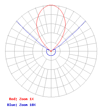 | ||||||||||||||||||
| Azimuth | Ratio | Azimuth | Ratio | Azimuth | Ratio | Azimuth | Ratio | ||||||||||||
| 0 | 1.000 | 10 | 0.947 | 20 | 0.812 | 30 | 0.622 | ||||||||||||
| 40 | 0.361 | 50 | 0.086 | 60 | 0.010 | 70 | 0.010 | ||||||||||||
| 80 | 0.010 | 90 | 0.010 | 100 | 0.010 | 110 | 0.010 | ||||||||||||
| 120 | 0.010 | 130 | 0.010 | 140 | 0.010 | 150 | 0.010 | ||||||||||||
| 160 | 0.010 | 170 | 0.010 | 180 | 0.010 | 190 | 0.010 | ||||||||||||
| 200 | 0.010 | 210 | 0.010 | 220 | 0.010 | 230 | 0.010 | ||||||||||||
| 240 | 0.010 | 250 | 0.010 | 260 | 0.010 | 270 | 0.010 | ||||||||||||
| 280 | 0.010 | 290 | 0.010 | 300 | 0.010 | 310 | 0.086 | ||||||||||||
| 320 | 0.361 | 330 | 0.622 | 340 | 0.812 | 350 | 0.947 | ||||||||||||
Structure Registration Number 1227604 Structure Type: TOWER Registered To: SBA Towers II LLC Structure Address: 1308 West Pine Street (ms10346-a) Hattiesburg, MS County Name: Forrest County ASR Issued: 04/08/2008 Date Built: 09/13/2001 Site Elevation: 57.9 m (190 ft.) Structure Height: 76.5 m (251 ft.) Height Overall: 80.2 m (263 ft.) Overall Height AMSL: 138.1 m (453 ft.) FAA Determination: 01/16/2008 FAA Study #: 2007-ASO-7242-OE FAA Circular #: 70/7460-1K Paint & Light FAA Chapters: 4, 8, 12 PRIOR STUDY 2001-ASO-3269-OE 31-18-50.0 N 89-18-12.3 W (NAD 83) 31-18-49.4 N 89-18-12.1 W (Converted to NAD 27) |
1498 Buford Hwy Ste C 275 Sugar Hill, GA 30518 Phone: 770-771-1644 Corporation | Title: President Date: 08/27/2021 Application Certifier PRISM BROADCASTING NETWORK, INC. Prism Broadcasting Network, Inc. 7742 Spalding Dr. Suite 475 Norcross, GA 30092 Applicant Susan Hanson B W St Clair 2305 Vida Shaw Rd New Iberia, LA 70563 Jim McDonald B. W. St. Clair 117 East Eleventh St. Loveland, CO 80537 ENGINEERING CONSULTANT | |||||||||||||||||