
FCCInfo.com
A Service of Cavell, Mertz & Associates, Inc.
(855) FCC-INFO
|
|
KILM from 02/07/1992 KILM from 04/10/1985 KILM from 01/18/1984 |
RF spectrum relinquished in the spectrum auction Virtual Channel 64 |  |
|
|||||||||||||||||||||
|
|
KILM is a channel sharing guest of KPXN-TV, San Bernardino, California Repacking Information: Channel 44 was relinquished in the spectrum auction Status: STA – Special Temporary Authority Application Accepted: 09/03/2021 STA Expires: 00/00/0000 File Number: -0000158566 FCC Website Links: LMS Facility Details This Application Other KILM Applications Including Superseded Applications Mailing Address Correspondence for KILM Correspondence related to application -0000158566 Service Contour - Open Street Map or USGS Map (41 dBu) Service Contour - KML / Google Earth (41 dBu) Public Inspection Files Rabbit Ears Info Search for KILM Site Location: 34-13-36.0 N 118-04-02.2 W (NAD 83) Site Location: 34-13-36.0 N 118-03-59.0 W (Converted to NAD 27) ERP: 156 kW Polarization: Horizontally polarized HAAT: 900.24 m (2954 ft.) Electrical Beam Tilt: 1.05 degrees R/C AGL: 38.1 m (125 ft.) R/C AMSL: 1772.4 m (5815 ft.) Site Elevation: 1734.3 m. (5690 ft.) Height Overall*: 64 m (210 ft.) (* As Filed In This Application, may differ from ASR Data, Below.) Directional Antenna - Antenna Make/Model: DIELECTRIC TFU-8WB-R C160 Antenna ID: 1008647 Polarization: Horizontally polarized
| ||||||||||||||||||||||||
| Antenna Data for Antenna Id: 1008647 KILM DT File: -0000158566 DIELECTRIC - TFU-8WB-R C160 Service: DT Standard Pattern: N | 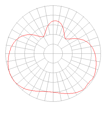 | ||||||||||||||||||||||||
| Azimuth | Ratio | Azimuth | Ratio | Azimuth | Ratio | Azimuth | Ratio | ||||||||||||||||||
| 0 | 0.672 | 10 | 0.671 | 20 | 0.590 | 30 | 0.470 | ||||||||||||||||||
| 40 | 0.404 | 50 | 0.471 | 60 | 0.609 | 70 | 0.735 | ||||||||||||||||||
| 80 | 0.822 | 90 | 0.877 | 100 | 0.916 | 110 | 0.952 | ||||||||||||||||||
| 120 | 0.982 | 130 | 0.966 | 140 | 0.983 | 150 | 0.943 | ||||||||||||||||||
| 160 | 0.888 | 170 | 0.836 | 180 | 0.805 | 190 | 0.805 | ||||||||||||||||||
| 200 | 0.837 | 210 | 0.890 | 220 | 0.946 | 230 | 0.986 | ||||||||||||||||||
| 240 | 1.000 | 250 | 0.987 | 260 | 0.955 | 270 | 0.918 | ||||||||||||||||||
| 280 | 0.876 | 290 | 0.820 | 300 | 0.732 | 310 | 0.607 | ||||||||||||||||||
| 320 | 0.472 | 330 | 0.406 | 340 | 0.471 | 350 | 0.591 | ||||||||||||||||||
Structure Registration Number 1036897 Structure Type: Registered To: American Towers LLC Structure Address: Tower 19, Mt. Wilson Antenna Farm/25 Km Ne Of Los Angeles, CA County Name: Los Angeles County ASR Issued: 01/05/2021 Date Built: 09/30/1999 Site Elevation: 1734.3 m (5690 ft.) Structure Height: 46 m (151 ft.) Height Overall: 64 m (210 ft.) Overall Height AMSL: 1798.3 m (5900 ft.) FAA Determination: 12/10/1997 FAA Study #: 97-AWP-2875-OE Paint & Light FAA Chapters: NONE 34-13-36.0 N 118-04-02.2 W (NAD 83) 34-13-36.0 N 118-03-59.0 W (Converted to NAD 27) |
312 Walnut Street 28th Floor Cincinnati, OH 45202 Phone: 513-977-3000 Limited Liability Company | Title: Vp, Station Operations Date: 09/03/2021 Application Certifier ION MEDIA LICENSE COMPANY, LLC Ion Media License Company, Llc 601 Clearwater Park Road West Palm Beach, FL 33401 Applicant David Giles Giles The E.w. Scripps Company 312 Walnut Street Cincinnati, OH 45202 James Collins Collins The E.w. Scripps Company 14444 66th Street North Clearwater, FL 33764 | |||||||||||||||||||||||