
FCCInfo.com
A Service of Cavell, Mertz & Associates, Inc.
(855) FCC-INFO
|
|
WOHZ-CD from 01/05/2005 WOHZ-CD from 12/15/1995 WOHZ-CD from 10/31/1989 |
Post-repack Channel 20 |  |
|
|||||||||||||||
|
|
Repacking Information: Pre-Repack Channel: 41 Post-Repack Channel: 20 Post-Repack ERP: 9.63 kW Phase: 4 Completion Deadline: 8/2/2019 Find nearby TV Facilities Status: License Application Accepted: 09/03/2021 License Expires: 10/01/2021 File Number: -0000158522 FCC Website Links: LMS Facility Details This Application Other WOHZ-CD Applications Including Superseded Applications Mailing Address Correspondence for WOHZ-CD Correspondence related to application -0000158522 Service Contour - Open Street Map or USGS Map (51 dBu) Service Contour - KML / Google Earth (51 dBu) Public Inspection Files Rabbit Ears Info Search for WOHZ-CD Site Location: 40-53-24.0 N 81-16-11.0 W (NAD 83) Site Location: 40-53-23.8 N 81-16-11.6 W (Converted to NAD 27) ERP: 15 kW Polarization: Elliptically polarized Electrical Beam Tilt: 1.0 degree R/C AGL: 219.5 m (720 ft.) R/C AMSL: 605.3 m (1986 ft.) Emission Mask: Full Service Site Elevation: 385.8 m. (1266 ft.) Height Overall*: 238.7 m (783 ft.) (* As Filed In This Application, may differ from ASR Data, Below.) Directional Antenna - Antenna Make/Model: Dielectric TLP-8F/VP-R Antenna ID: 1008644 Polarization: Elliptically polarized | ||||||||||||||||||
| Antenna Data for Antenna Id: 1008644 WOHZ-CD DC File: -0000158522 Dielectric - TLP-8F/VP-R Service: DC Standard Pattern: N Pattern and Field Values Include a 220° Clockwise Rotation | 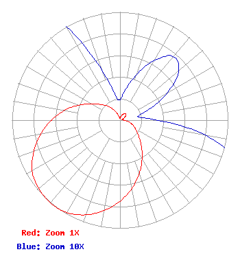 | ||||||||||||||||||
| Azimuth | Ratio | Azimuth | Ratio | Azimuth | Ratio | Azimuth | Ratio | ||||||||||||
| 0 | 0.019 | 10 | 0.028 | 20 | 0.045 | 30 | 0.064 | ||||||||||||
| 40 | 0.077 | 50 | 0.071 | 60 | 0.051 | 70 | 0.028 | ||||||||||||
| 80 | 0.017 | 90 | 0.035 | 100 | 0.080 | 110 | 0.125 | ||||||||||||
| 120 | 0.168 | 130 | 0.224 | 140 | 0.304 | 150 | 0.409 | ||||||||||||
| 160 | 0.525 | 170 | 0.640 | 180 | 0.750 | 190 | 0.849 | ||||||||||||
| 200 | 0.932 | 210 | 0.987 | 220 | 1.000 | 230 | 0.983 | ||||||||||||
| 240 | 0.939 | 250 | 0.850 | 260 | 0.745 | 270 | 0.634 | ||||||||||||
| 280 | 0.521 | 290 | 0.405 | 300 | 0.296 | 310 | 0.223 | ||||||||||||
| 320 | 0.165 | 330 | 0.101 | 340 | 0.049 | 350 | 0.023 | ||||||||||||
Structure Registration Number 1015774 Structure Type: TOWER Registered To: American Towers LLC Structure Address: 8 Miles Ne Canton, OH County Name: Stark County ASR Issued: 04/14/2014 Date Built: 07/14/2001 Site Elevation: 385.8 m (1266 ft.) Structure Height: 238 m (781 ft.) Height Overall: 238.7 m (783 ft.) Overall Height AMSL: 624.5 m (2049 ft.) FAA Determination: 09/10/1997 FAA Study #: 97-AGL-0442-OE FAA Circular #: 70/7460-1J Paint & Light FAA Chapters: 3, 4, 5, 13 Removed expiration and final dates from determination. Scenario 2./jjs/case#635066 40-53-24.0 N 81-16-11.0 W (NAD 83) 40-53-23.8 N 81-16-11.6 W (Converted to NAD 27) |
4370 Peachtree Road, Ne Atlanta, GA 30319 Phone: 404-504-9828 Limited Liability Company | Title: Assistant Secretary Date: 09/03/2021 Application Certifier Gray Television Licensee, Llc 4370 Peachtree Road, Ne Atlanta, GA 30319 Applicant Joan Stewart Wiley Rein Llp 1776 K Street, Nw Washington, DC 20006 Joseph M. Davis, P.E. Chesapeake Rf Consultants, Llc 207 Old Dominion Road Yorktown, VA 23692 Consulting Engineer | |||||||||||||||||