
FCCInfo.com
A Service of Cavell, Mertz & Associates, Inc.
(855) FCC-INFO
|
|
KDJT-CD from 09/17/2001 KDJT-CD from 10/18/1993 KDJT-CD from 09/15/1993 KDJT-CD from 11/30/1989 |
Post-repack Channel 26 Virtual Channel 33 |
|
||||||||||||||||
|
|
KDJT-CD is a channel sharing host for KSMS-TV, Monterey, California Repacking Information: Pre-Repack Channel: 33 Post-Repack Channel: 26 Phase: 2 Completion Deadline: 4/12/2019 Find nearby TV Facilities Status: License Application Accepted: 09/13/2021 License Expires: 12/01/2022 File Number: -0000159177 FCC Website Links: LMS Facility Details This Application Other KDJT-CD Applications Including Superseded Applications Mailing Address Correspondence for KDJT-CD Correspondence related to application -0000159177 Service Contour - Open Street Map or USGS Map (51 dBu) Service Contour - KML / Google Earth (51 dBu) Public Inspection Files Rabbit Ears Info Search for KDJT-CD Site Location: 36-45-22.8 N 121-30-08.7 W (NAD 83) Site Location: 36-45-22.9 N 121-30-04.9 W (Converted to NAD 27) ERP: 15 kW Polarization: Horizontally polarized R/C AGL: 82 m (269 ft.) R/C AMSL: 1019.8 m (3346 ft.) Emission Mask: Full Service Site Elevation: 937.8 m. (3077 ft.) Height Overall*: 122.5 m (402 ft.) (* As Filed In This Application, may differ from ASR Data, Below.) Directional Antenna - Antenna Make/Model: DIELECTRIC TLP-8M Antenna ID: 118353 Polarization: Horizontally polarized | ||||||||||||||||||
| Antenna Data for Antenna Id: 118353 KDJT-CD DC File: -0000159177 DIELECTRIC - TLP-8M Service: DC Standard Pattern: Y | 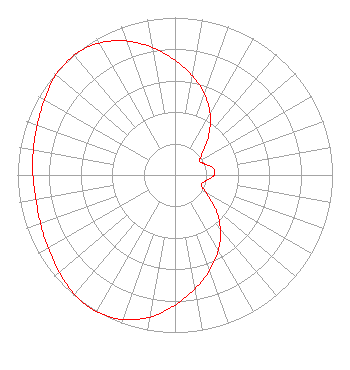 | ||||||||||||||||||
| Azimuth | Ratio | Azimuth | Ratio | Azimuth | Ratio | Azimuth | Ratio | ||||||||||||
| 0 | 0.730 | 10 | 0.639 | 20 | 0.546 | 30 | 0.446 | ||||||||||||
| 40 | 0.335 | 50 | 0.232 | 60 | 0.180 | 70 | 0.202 | ||||||||||||
| 80 | 0.247 | 90 | 0.248 | 100 | 0.202 | 110 | 0.178 | ||||||||||||
| 120 | 0.229 | 130 | 0.334 | 140 | 0.449 | 150 | 0.552 | ||||||||||||
| 160 | 0.644 | 170 | 0.733 | 180 | 0.826 | 190 | 0.916 | ||||||||||||
| 200 | 0.977 | 210 | 1.000 | 220 | 0.990 | 230 | 0.960 | ||||||||||||
| 240 | 0.930 | 250 | 0.908 | 260 | 0.897 | 270 | 0.902 | ||||||||||||
| 280 | 0.914 | 290 | 0.930 | 300 | 0.958 | 310 | 0.988 | ||||||||||||
| 320 | 0.995 | 330 | 0.967 | 340 | 0.906 | 350 | 0.821 | ||||||||||||
Structure Registration Number 1215158 Structure Type: LTOWER Registered To: Hearst Stations Inc. Structure Address: Fremont Peak, Approximatley 16 Km Northeast Of Salinas San Juan Bautis, CA County Name: Monterey County ASR Issued: 11/22/2016 Date Built: 12/05/2002 Site Elevation: 937.8 m (3077 ft.) Structure Height: 121.6 m (399 ft.) Height Overall: 122.5 m (402 ft.) Overall Height AMSL: 1060.3 m (3479 ft.) FAA Determination: 03/19/1999 FAA Study #: 99-AWP-0164-OE FAA Circular #: 70/7460-1J Paint & Light FAA Chapters: 3, 4, 5, 13 36-45-22.8 N 121-30-08.7 W (NAD 83) 36-45-22.9 N 121-30-04.9 W (Converted to NAD 27) |
2425 Olympic Blvd Ste 6000 W Santa Monica, CA 90404 Phone: 310-447-3870 Limited Liability Company | Title: Chief Executive Officer Date: 09/13/2021 Application Certifier Entravision Holdings, Llc 2425 Olympic Blvd Ste 6000 W Santa Monica, CA 90404 Applicant BARRY A. FRIEDMAN Thompson Hine Llp Suite 700 1919 M Street, N.w. Washington, DC 20036 William Jeffrey Reynolds Du Treil, Lundin & Rackley, Inc. 5120 Station Way Sarasota, FL 34233 Technical Consultant | |||||||||||||||||
| |||||||||||||||||||