
FCCInfo.com
A Service of Cavell, Mertz & Associates, Inc.
(855) FCC-INFO
|
|
W20EU-D from 07/02/2010 W20EU-D from 03/04/2002 W20EU-D from 12/04/1998 |
|
|
||||||||||||||||
|
|
Status: License Application Accepted: 09/13/2021 License Expires: 08/01/2023 File Number: -0000159182 FCC Website Links: LMS Facility Details This Application Other W20EU-D Applications Including Superseded Applications Mailing Address Correspondence for W20EU-D Correspondence related to application -0000159182 Service Contour - Open Street Map or USGS Map (51 dBu) Service Contour - KML / Google Earth (51 dBu) Rabbit Ears Info Search for W20EU-D Site Location: 40-03-00.3 N 77-44-50.9 W (NAD 83) Site Location: 40-02-60.0 N 77-44-51.9 W (Converted to NAD 27) ERP: 15 kW Polarization: Elliptically polarized Electrical Beam Tilt: 1.75 degrees R/C AGL: 24.4 m (80 ft.) R/C AMSL: 731.5 m (2400 ft.) Emission Mask: Full Service Site Elevation: 707.1 m. (2320 ft.) Height Overall*: 59.4 m (195 ft.) (* As Filed In This Application, may differ from ASR Data, Below.) Directional Antenna - Antenna Make/Model: Electronics Research Inc. AL8N-20-E Antenna ID: 1008677 Polarization: Elliptically polarized
| ||||||||||||||||||
| Antenna Data for Antenna Id: 1008677 W20EU-D LD File: -0000159182 Electronics Research Inc. - AL8N-20-E Service: LD Standard Pattern: N Pattern and Field Values Include a 45.0° Clockwise Rotation | 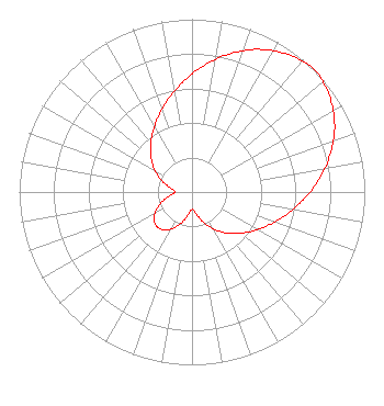 | ||||||||||||||||||
| Azimuth | Ratio | Azimuth | Ratio | Azimuth | Ratio | Azimuth | Ratio | ||||||||||||
| 5 | 0.731 | 15 | 0.827 | 25 | 0.911 | 35 | 0.971 | ||||||||||||
| 45 | 1.000 | 55 | 0.971 | 65 | 0.911 | 75 | 0.827 | ||||||||||||
| 85 | 0.731 | 95 | 0.636 | 105 | 0.549 | 115 | 0.471 | ||||||||||||
| 125 | 0.403 | 135 | 0.340 | 145 | 0.279 | 155 | 0.215 | ||||||||||||
| 165 | 0.151 | 175 | 0.104 | 185 | 0.111 | 195 | 0.165 | ||||||||||||
| 205 | 0.224 | 215 | 0.268 | 225 | 0.284 | 235 | 0.268 | ||||||||||||
| 245 | 0.224 | 255 | 0.165 | 265 | 0.111 | 275 | 0.104 | ||||||||||||
| 285 | 0.151 | 295 | 0.215 | 305 | 0.279 | 315 | 0.340 | ||||||||||||
| 325 | 0.403 | 335 | 0.471 | 345 | 0.549 | 355 | 0.636 | ||||||||||||
Structure Registration Number 1200405 Structure Type: TOWER Registered To: PENNSYLVANIA TURNPIKE COMMISSION Structure Address: 2 Miles Sw Upper Strasburg, PA County Name: Franklin County ASR Issued: 05/12/2000 Date Built: 12/16/1999 Site Elevation: 707.1 m (2320 ft.) Structure Height: 54.9 m (180 ft.) Height Overall: 59.4 m (195 ft.) Overall Height AMSL: 766.5 m (2515 ft.) FAA Determination: 04/11/1999 FAA Study #: 99-AEA-0334-OE Paint & Light FAA Chapters: NONE PRIOR FAA 98-AEA-0859-OE 40-03-00.3 N 77-44-50.9 W (NAD 83) 40-02-60.0 N 77-44-51.9 W (Converted to NAD 27) |
4801 Lindle Road Harrisburg, PA 17111 Phone: 717-704-3000 Not-for-Profit | Title: Svp And Chief Business Officer Date: 09/13/2021 Application Certifier Witf, Inc. 4801 Lindle Road Harrisburg, PA 17111 Applicant William Meintel Meintel, Sgrignoli & Wallace, Llc Warrenton, VA 20188 Senior Partner Barry S. Persh Gray Miller Persh Llp 2233 Wisconsin Ave., Nw Suite 226 Washington, DC 20007 | |||||||||||||||||