
FCCInfo.com
A Service of Cavell, Mertz & Associates, Inc.
(855) FCC-INFO
|
|
W19ET-D from 03/23/2012 W19ET-D from 11/28/1994 |
|
|
||||||||||||||||
|
|
Status: License Application Accepted: 09/22/2021 License Expires: 06/01/2023 File Number: -0000160038 FCC Website Links: LMS Facility Details This Application Other W19ET-D Applications Including Superseded Applications Mailing Address Correspondence for W19ET-D Correspondence related to application -0000160038 Service Contour - Open Street Map or USGS Map (51 dBu) Service Contour - KML / Google Earth (51 dBu) Rabbit Ears Info Search for W19ET-D Site Location: 42-17-32.0 N 77-40-26.0 W (NAD 83) Site Location: 42-17-31.7 N 77-40-27.0 W (Converted to NAD 27) ERP: 0.8 kW Polarization: Horizontally polarized R/C AGL: 11 m (36 ft.) R/C AMSL: 645 m (2116 ft.) Emission Mask: Simple Site Elevation: 634 m. (2080 ft.) Height Overall*: 64.6 m (212 ft.) (* As Filed In This Application, may differ from ASR Data, Below.) Directional Antenna - Antenna Make/Model: Scala 4DR-4S Antenna ID: 96411 Polarization: Horizontally polarized | ||||||||||||||||||
| Antenna Data for Antenna Id: 96411 W19ET-D LD File: -0000160038 Scala - 4DR-4S Service: LD Standard Pattern: Y Pattern and Field Values Include a 80.0° Clockwise Rotation | 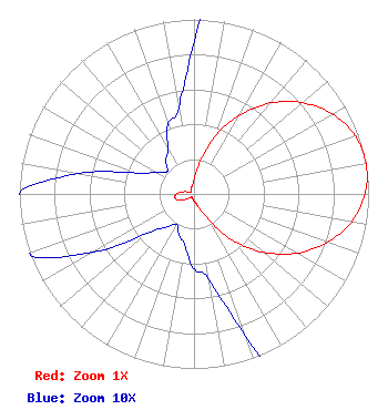 | ||||||||||||||||||
| Azimuth | Ratio | Azimuth | Ratio | Azimuth | Ratio | Azimuth | Ratio | ||||||||||||
| 0 | 0.087 | 10 | 0.175 | 20 | 0.350 | 30 | 0.520 | ||||||||||||
| 40 | 0.680 | 50 | 0.812 | 60 | 0.916 | 70 | 0.980 | ||||||||||||
| 80 | 1.000 | 90 | 0.980 | 100 | 0.916 | 110 | 0.812 | ||||||||||||
| 120 | 0.680 | 130 | 0.520 | 140 | 0.350 | 150 | 0.175 | ||||||||||||
| 160 | 0.087 | 170 | 0.050 | 180 | 0.043 | 190 | 0.030 | ||||||||||||
| 200 | 0.025 | 210 | 0.020 | 220 | 0.025 | 230 | 0.035 | ||||||||||||
| 240 | 0.067 | 250 | 0.102 | 260 | 0.110 | 270 | 0.102 | ||||||||||||
| 280 | 0.067 | 290 | 0.035 | 300 | 0.025 | 310 | 0.020 | ||||||||||||
| 320 | 0.025 | 330 | 0.030 | 340 | 0.043 | 350 | 0.050 | ||||||||||||
Structure Registration Number 1053378 Structure Type: TOWER Registered To: Seven Mountains Media, LLC Structure Address: 6060 Gypsy Hill Rd Hornell, NY County Name: Steuben County ASR Issued: 02/12/2024 Date Built: 01/01/1984 Site Elevation: 634 m (2080 ft.) Structure Height: 64 m (210 ft.) Height Overall: 64.6 m (212 ft.) Overall Height AMSL: 698.6 m (2292 ft.) Paint & Light FAA Chapters: 1, 3, 11, 21 42-17-32.0 N 77-40-26.0 W (NAD 83) 42-17-31.7 N 77-40-27.0 W (Converted to NAD 27) |
2750 Luberon Lane Cumming, GA 30041 Phone: 678-777-8659 Limited Liability Company | Title: President Date: 09/22/2021 Application Certifier Wydc, Inc. 482 Harbor Drive North Indian Rocks Beach, FL 33785 Applicant Mark Denbo Smithwick & Belendiuk, P.c. 5028 Wisconsin Avenue, N.w. Suite 301 Washington, DC 20016 Counsel Carl E Gluck, Consultant Carl T Jones Corp 7901 Yarnwood Court Springfield, VA 22153 Technical Consultant | |||||||||||||||||