
FCCInfo.com
A Service of Cavell, Mertz & Associates, Inc.
(855) FCC-INFO
|
|
K36QD-D from 05/30/2006 K36QD-D from 10/23/1995 |
|
|
||||||||||||||||
|
|
Status: License Application Accepted: 09/27/2021 License Expires: 06/01/2022 File Number: -0000160449 FCC Website Links: LMS Facility Details This Application Other K36QD-D Applications Including Superseded Applications Mailing Address Correspondence for K36QD-D Correspondence related to application -0000160449 Service Contour - Open Street Map or USGS Map (51 dBu) Service Contour - KML / Google Earth (51 dBu) Rabbit Ears Info Search for K36QD-D Site Location: 41-23-27.0 N 96-54-25.0 W (NAD 83) Site Location: 41-23-27.0 N 96-54-23.9 W (Converted to NAD 27) ERP: 2 kW Polarization: Horizontally polarized R/C AGL: 83.8 m (275 ft.) R/C AMSL: 580.6 m (1905 ft.) Emission Mask: Full Service Site Elevation: 496.8 m. (1630 ft.) Height Overall*: 95.7 m (314 ft.) (* As Filed In This Application, may differ from ASR Data, Below.) Directional Antenna - Antenna Make/Model: Scala PR-TV x2 Array 1@100 1@350 Antenna ID: 1008723 Polarization: Horizontally polarized
| ||||||||||||||||||
| Antenna Data for Antenna Id: 1008723 K36QD-D LD File: -0000160449 Scala - PR-TV x2 Array 1@100 1@350 Service: LD Standard Pattern: N | 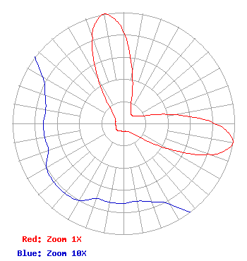 | ||||||||||||||||||
| Azimuth | Ratio | Azimuth | Ratio | Azimuth | Ratio | Azimuth | Ratio | ||||||||||||
| 0 | 0.815 | 10 | 0.456 | 20 | 0.204 | 30 | 0.133 | ||||||||||||
| 40 | 0.107 | 50 | 0.107 | 60 | 0.133 | 70 | 0.204 | ||||||||||||
| 80 | 0.456 | 90 | 0.815 | 95 | 0.944 | 100 | 1.000 | ||||||||||||
| 105 | 0.946 | 110 | 0.816 | 120 | 0.450 | 130 | 0.194 | ||||||||||||
| 140 | 0.115 | 150 | 0.084 | 160 | 0.075 | 170 | 0.071 | ||||||||||||
| 180 | 0.072 | 190 | 0.072 | 200 | 0.072 | 210 | 0.080 | ||||||||||||
| 220 | 0.082 | 230 | 0.082 | 240 | 0.080 | 250 | 0.072 | ||||||||||||
| 260 | 0.072 | 270 | 0.072 | 280 | 0.071 | 290 | 0.075 | ||||||||||||
| 300 | 0.084 | 310 | 0.115 | 320 | 0.194 | 330 | 0.450 | ||||||||||||
| 340 | 0.816 | 345 | 0.946 | 350 | 1.000 | 355 | 0.944 | ||||||||||||
Structure Registration Number 1025825 Structure Type: TOWER Registered To: American Towers LLC Structure Address: 8.4 Km South Of Us-30; 8.2 Km West Of Sr-79; 2.3 Km Southeast Of Linwood, NE County Name: Saunders County ASR Issued: 12/09/2016 Date Built: 08/01/1996 Site Elevation: 496.8 m (1630 ft.) Structure Height: 91.4 m (300 ft.) Height Overall: 95.7 m (314 ft.) Overall Height AMSL: 592.5 m (1944 ft.) FAA Determination: 07/05/1996 FAA Study #: 96-ACE-0495-OE FAA Circular #: 70/7460-1J Paint & Light FAA Chapters: 4, 8, 13 FAA 7460-2 DATED 7/25/96 INDICATES TOWER REACHED 314FT WITH DUAL LIGHTS ON 7/15/96. BJE. 41-23-27.0 N 96-54-25.0 W (NAD 83) 41-23-27.0 N 96-54-23.9 W (Converted to NAD 27) |
Chattanooga, TN 37401 Phone: 423-468-5100 Limited Liability Company | Title: Coo Date: 09/27/2021 Application Certifier DIGITAL NETWORKS-MIDWEST, LLC Digital Networks-midwest, Llc Chattanooga, TN 37401 Applicant Jeremy D Ruck, PE Jeremy Ruck & Associates, Inc. Canton, IL 61520 Consulting Engineer Aaron P Shainis Shainis & Peltzman, Chartered 1850 M St. Nw Suite 240 Washington, DC 20036 FCC Legal Counsel | |||||||||||||||||