
FCCInfo.com
A Service of Cavell, Mertz & Associates, Inc.
(855) FCC-INFO
|
|
DWNYP-LD from 04/03/2024 from 10/20/2022 from 12/07/2016 from 12/06/2016 from 11/07/2012 from 02/20/2004 |
|
|
||||||||||||||||
|
|
Status: STA – Special Temporary Authority (Licensed And Silent) Application Accepted: 10/12/2021 STA Expires: 00/00/0000 File Number: -0000163551 FCC Website Links: LMS Facility Details This Application Other WNYP-LD Applications Including Superseded Applications Mailing Address Correspondence for WNYP-LD Correspondence related to application -0000163551 Service Contour - Open Street Map or USGS Map (51 dBu) Service Contour - KML / Google Earth (51 dBu) Rabbit Ears Info Search for WNYP-LD Site Location: 40-57-39.0 N 73-55-21.0 W (NAD 83) Site Location: 40-57-38.6 N 73-55-22.5 W (Converted to NAD 27) ERP: 14.8 kW Polarization: Elliptically polarized R/C AGL: 82.3 m (270 ft.) R/C AMSL: 240.8 m (790 ft.) Emission Mask: Full Service Site Elevation: 158.5 m. (520 ft.) Height Overall*: 129.6 m (425 ft.) (* As Filed In This Application, may differ from ASR Data, Below.) Directional Antenna - Antenna Make/Model: Electronics Research Inc. ALP4L-ESBR-28 Antenna ID: 1005564 Polarization: Elliptically polarized | ||||||||||||||||||
| Antenna Data for Antenna Id: 1005564 WNYP-LD LD File: -0000163551 Electronics Research Inc. - ALP4L-ESBR-28 Service: LD Standard Pattern: Y Pattern and Field Values Include a 48° Clockwise Rotation | 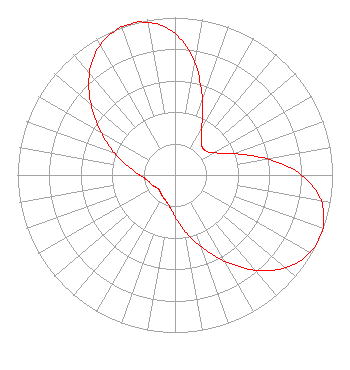 | ||||||||||||||||||
| Azimuth | Ratio | Azimuth | Ratio | Azimuth | Ratio | Azimuth | Ratio | ||||||||||||
| 8 | 0.765 | 18 | 0.549 | 28 | 0.364 | 38 | 0.269 | ||||||||||||
| 48 | 0.246 | 58 | 0.269 | 68 | 0.364 | 78 | 0.549 | ||||||||||||
| 88 | 0.765 | 98 | 0.923 | 108 | 0.992 | 113 | 1.000 | ||||||||||||
| 118 | 0.994 | 128 | 0.936 | 138 | 0.818 | 148 | 0.664 | ||||||||||||
| 158 | 0.513 | 168 | 0.386 | 178 | 0.282 | 188 | 0.211 | ||||||||||||
| 198 | 0.177 | 208 | 0.161 | 218 | 0.146 | 228 | 0.137 | ||||||||||||
| 238 | 0.146 | 248 | 0.161 | 258 | 0.177 | 268 | 0.211 | ||||||||||||
| 278 | 0.282 | 288 | 0.386 | 298 | 0.513 | 308 | 0.664 | ||||||||||||
| 318 | 0.818 | 328 | 0.936 | 338 | 0.994 | 343 | 1.000 | ||||||||||||
| 348 | 0.992 | 358 | 0.923 | ||||||||||||||||
Structure Registration Number 1048672 Structure Type: TOWER Registered To: K2 Towers II, LLC Structure Address: Us Rt 9w Alpine, NJ County Name: Bergen County ASR Issued: 12/24/2019 Date Built: 05/22/2003 Site Elevation: 158.5 m (520 ft.) Structure Height: 121.9 m (400 ft.) Height Overall: 129.6 m (425 ft.) Overall Height AMSL: 288.1 m (945 ft.) FAA Determination: 06/03/2003 FAA Study #: 2001-AEA-3702-OE FAA Circular #: 70/7460-1K Paint & Light FAA Chapters: 3, 4, 5, 12 PRIOR STUDY 73-AEA-1004-OE 40-57-39.0 N 73-55-21.0 W (NAD 83) 40-57-38.6 N 73-55-22.5 W (Converted to NAD 27) |
150 S Arroyo Pkwy #103 Pasadena, CA 91105 Phone: 323-965-5400 Limited Liability Company | Title: Manager Date: 10/12/2021 Application Certifier VENTURE TECHNOLOGIES GROUP, LLC Venture Technologies Group, Llc 5670 Wilshire Blvd Ste 1620 Los Angeles, CA 90036 Applicant LAWRENCE ROGOW ROGOW Venture Technologies Group, Llc 5670 Wilshire Blvd Ste 1620 Los Angeles, CA 90036 JOAN STEWART STEWART Wiley Rein Llp 1776 K Street Nw Washington, DC 20006 | |||||||||||||||||