
FCCInfo.com
A Service of Cavell, Mertz & Associates, Inc.
(855) FCC-INFO
|
|
K29NC-D from 09/14/2012 K29NC-D from 05/10/2005 K29NC-D from 12/09/1999 K29NC-D from 08/04/1992 |
|
|
||||||||||||||||
|
|
Status: License Application Accepted: 10/12/2021 License Expires: 10/18/2021 File Number: -0000163541 FCC Website Links: LMS Facility Details This Application Other K29NC-D Applications Including Superseded Applications Mailing Address Correspondence for K29NC-D Correspondence related to application -0000163541 Service Contour - Open Street Map or USGS Map (51 dBu) Service Contour - KML / Google Earth (51 dBu) Rabbit Ears Info Search for K29NC-D Site Location: 32-39-36.0 N 92-05-15.0 W (NAD 83) Site Location: 32-39-35.5 N 92-05-14.5 W (Converted to NAD 27) ERP: 15 kW Polarization: Horizontally polarized Electrical Beam Tilt: 0.5 degrees R/C AGL: 152 m (499 ft.) R/C AMSL: 174.6 m (573 ft.) Emission Mask: Stringent Site Elevation: 22.6 m. (74 ft.) Height Overall*: 327.6 m (1075 ft.) (* As Filed In This Application, may differ from ASR Data, Below.) Directional Antenna - Antenna Make/Model: Systems With Reliability SWEDL12OI/29 Antenna ID: 1008788 Polarization: Horizontally polarized | ||||||||||||||||||
| Antenna Data for Antenna Id: 1008788 K29NC-D LD File: -0000163541 Systems With Reliability - SWEDL12OI/29 Service: LD Standard Pattern: N Pattern and Field Values Include a 180° Clockwise Rotation | 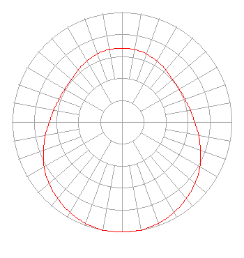 | ||||||||||||||||||
| Azimuth | Ratio | Azimuth | Ratio | Azimuth | Ratio | Azimuth | Ratio | ||||||||||||
| 0 | 0.670 | 10 | 0.670 | 20 | 0.660 | 30 | 0.640 | ||||||||||||
| 40 | 0.620 | 50 | 0.600 | 60 | 0.600 | 70 | 0.610 | ||||||||||||
| 80 | 0.630 | 90 | 0.660 | 100 | 0.710 | 110 | 0.760 | ||||||||||||
| 120 | 0.820 | 130 | 0.870 | 140 | 0.910 | 150 | 0.950 | ||||||||||||
| 160 | 0.980 | 170 | 1.000 | 180 | 1.000 | 190 | 1.000 | ||||||||||||
| 200 | 0.980 | 210 | 0.950 | 220 | 0.910 | 230 | 0.870 | ||||||||||||
| 240 | 0.820 | 250 | 0.760 | 260 | 0.710 | 270 | 0.660 | ||||||||||||
| 280 | 0.630 | 290 | 0.610 | 300 | 0.600 | 310 | 0.600 | ||||||||||||
| 320 | 0.620 | 330 | 0.640 | 340 | 0.660 | 350 | 0.670 | ||||||||||||
Structure Registration Number 1034014 Structure Type: TOWER Registered To: NEW SOUTH COMMUNICATIONS INC Structure Address: Approx 3.9 Km S Sterlington, LA County Name: Ouachita Parish ASR Issued: 01/02/1998 Date Built: 01/01/1987 Site Elevation: 22.6 m (74 ft.) Structure Height: 327.6 m (1075 ft.) Height Overall: 327.6 m (1075 ft.) Overall Height AMSL: 350.2 m (1149 ft.) FAA Determination: 04/17/1987 FAA Study #: 87-ASW-0351-OE Paint & Light FAA Chapters: B, E, H HIGH INTENSITY WHITE LIGHTS 32-39-36.0 N 92-05-15.0 W (NAD 83) 32-39-35.5 N 92-05-14.5 W (Converted to NAD 27) |
3313 Government St Suite G Baton Rouge, LA 70806 Phone: 225-334-7490 Applicant | Title: Manager Date: 10/12/2021 Application Certifier DEVELOPERS & MANAGERS GROUP, LLC Developers & Managers Group, Llc 3313 Government St Suite G Baton Rouge, LA 70806 Applicant WALTER PEARSON BEAVER, JR Walter P Beaver Jr Technical Service 1202 Jordan Drive Grand Prairie, TX 64157 TECHNICAL ADVISOR ERNEST L JOHNSON Developers And Managers Group, Llc 3313 Government Street Baton Rouge, LA 70806 DR | |||||||||||||||||