
FCCInfo.com
A Service of Cavell, Mertz & Associates, Inc.
(855) FCC-INFO
|
|
K04SA-D from 09/22/2011 |
|
|
||||||||||||||||
|
|
Status: License Application Accepted: 10/14/2021 License Expires: 06/01/2021 File Number: -0000163821 FCC Website Links: LMS Facility Details This Application Other K04SA-D Applications Including Superseded Applications Mailing Address Correspondence for K04SA-D Correspondence related to application -0000163821 Service Contour - Open Street Map or USGS Map (43 dBu) Service Contour - KML / Google Earth (43 dBu) Rabbit Ears Info Search for K04SA-D Site Location: 31-16-05.0 N 92-26-24.0 W (NAD 83) Site Location: 31-16-04.3 N 92-26-23.5 W (Converted to NAD 27) ERP: 3 kW Polarization: Horizontally polarized R/C AGL: 114 m (374 ft.) R/C AMSL: 137 m (449 ft.) Emission Mask: Stringent Site Elevation: 23 m. (75 ft.) Height Overall*: 128 m (420 ft.) (* As Filed In This Application, may differ from ASR Data, Below.) Directional Antenna - Antenna Make/Model: Kathrein Scala TVO-6-SFX-1.5kW Antenna ID: 1008821 Polarization: Horizontally polarized | ||||||||||||||||||
| Antenna Data for Antenna Id: 1008821 K04SA-D LD File: -0000163821 Kathrein Scala - TVO-6-SFX-1.5kW Service: LD Standard Pattern: N | 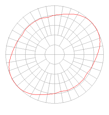 | ||||||||||||||||||
| Azimuth | Ratio | Azimuth | Ratio | Azimuth | Ratio | Azimuth | Ratio | ||||||||||||
| 0 | 0.800 | 10 | 0.830 | 20 | 0.875 | 30 | 0.935 | ||||||||||||
| 40 | 0.980 | 50 | 1.000 | 60 | 1.000 | 70 | 0.980 | ||||||||||||
| 80 | 0.935 | 90 | 0.875 | 100 | 0.830 | 110 | 0.800 | ||||||||||||
| 120 | 0.770 | 130 | 0.780 | 140 | 0.780 | 150 | 0.780 | ||||||||||||
| 160 | 0.780 | 170 | 0.770 | 180 | 0.800 | 190 | 0.830 | ||||||||||||
| 200 | 0.875 | 210 | 0.935 | 220 | 0.980 | 230 | 1.000 | ||||||||||||
| 240 | 1.000 | 250 | 0.980 | 260 | 0.935 | 270 | 0.875 | ||||||||||||
| 280 | 0.830 | 290 | 0.800 | 300 | 0.770 | 310 | 0.780 | ||||||||||||
| 320 | 0.780 | 330 | 0.780 | 340 | 0.780 | 350 | 0.770 | ||||||||||||
Structure Registration Number 1049416 Structure Type: TOWER Registered To: K2 Towers III, LLC Structure Address: Duhon Ln Alexandria, LA County Name: Rapides Parish ASR Issued: 02/04/2022 Date Built: 01/01/1978 Site Elevation: 23 m (75 ft.) Structure Height: 122 m (400 ft.) Height Overall: 128 m (420 ft.) Overall Height AMSL: 151 m (495 ft.) FAA Determination: 06/21/1978 FAA Study #: 78-ASW-1091-OE Paint & Light FAA Chapters: 1, 3, 12, 21 RED LIGHTS/PAINT 31-16-05.0 N 92-26-24.0 W (NAD 83) 31-16-04.3 N 92-26-23.5 W (Converted to NAD 27) |
3313 Government St Suite G Baton Rouge, LA 70806 Phone: 225-413-3219 Limited Liability Partnership | Title: Manager Date: 10/14/2021 Application Certifier DEVELOPERS & MANAGERS GROUP, LLC Developers & Managers Group, Llc 3313 Government St Suite G Baton Rouge, LA 70806 Applicant WALTER PEARSON BEAVER, JR Walter P Beaver Jr Technical Service 1202 Jordan Drive Grand Prairie, TX 75050 TECHNICAL ADVISOR DR. ERNEST JOHNSON Developers & Managers Group, Llc 3313 Government Street Baton Rouge, LA 70806 DR. | |||||||||||||||||