
FCCInfo.com
A Service of Cavell, Mertz & Associates, Inc.
(855) FCC-INFO
|
|
W13DS-D from 06/02/2020 W13DS-D from 01/26/2020 W13DS-D from 04/21/1997 W13DS-D from 02/03/1998 W13DS-D from 08/12/1986 |
|
|
|||||||||||||||||
|
|
Status: License Application Accepted: 10/20/2021 License Expires: 10/01/2029 File Number: -0000164310 FCC Website Links: LMS Facility Details This Application Other W13DS-D Applications Including Superseded Applications Mailing Address Correspondence for W13DS-D Correspondence related to application -0000164310 Service Contour - Open Street Map or USGS Map (48 dBu) Service Contour - KML / Google Earth (48 dBu) Rabbit Ears Info Search for W13DS-D Site Location: 41-45-26.0 N 81-02-29.0 W (NAD 83) Site Location: 41-45-25.8 N 81-02-29.7 W (Converted to NAD 27) ERP: 0.3 kW Polarization: Horizontally polarized R/C AGL: 30 m (98 ft.) R/C AMSL: 281.8 m (925 ft.) Emission Mask: Full Service Site Elevation: 251.8 m. (826 ft.) Height Overall*: 81 m (266 ft.) (* As Filed In This Application, may differ from ASR Data, Below.) Directional Antenna - Antenna Make/Model: Scala CL-713 x2 Array 1@90 1@230 Antenna ID: 1008840 Polarization: Horizontally polarized
| |||||||||||||||||||
| Antenna Data for Antenna Id: 1008840 W13DS-D LD File: -0000164310 Scala - CL-713 x2 Array 1@90 1@230 Service: LD Standard Pattern: N | 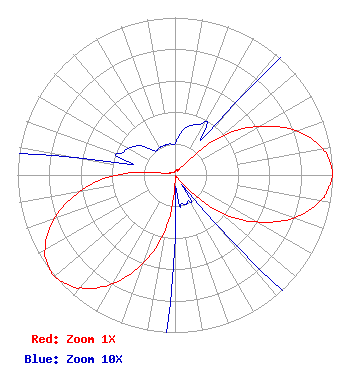 | |||||||||||||||||||
| Azimuth | Ratio | Azimuth | Ratio | Azimuth | Ratio | Azimuth | Ratio | |||||||||||||
| 0 | 0.020 | 10 | 0.029 | 20 | 0.034 | 30 | 0.039 | |||||||||||||
| 40 | 0.059 | 50 | 0.375 | 60 | 0.616 | 70 | 0.819 | |||||||||||||
| 80 | 0.951 | 85 | 0.987 | 90 | 1.000 | 95 | 0.977 | |||||||||||||
| 100 | 0.936 | 110 | 0.799 | 120 | 0.596 | 130 | 0.355 | |||||||||||||
| 140 | 0.039 | 150 | 0.020 | 160 | 0.020 | 170 | 0.020 | |||||||||||||
| 180 | 0.039 | 190 | 0.355 | 200 | 0.596 | 210 | 0.799 | |||||||||||||
| 220 | 0.936 | 225 | 0.977 | 230 | 1.000 | 235 | 0.987 | |||||||||||||
| 240 | 0.951 | 250 | 0.819 | 260 | 0.616 | 270 | 0.375 | |||||||||||||
| 280 | 0.059 | 290 | 0.039 | 300 | 0.034 | 310 | 0.029 | |||||||||||||
| 320 | 0.020 | 330 | 0.020 | 340 | 0.020 | 350 | 0.020 | |||||||||||||
Structure Registration Number 1015025 Structure Type: LTOWER Registered To: American Towers, LLC Structure Address: 22021 Brookpart Road (#307817) Madison, OH County Name: Lake County ASR Issued: 02/07/2020 Date Built: 07/25/2013 Site Elevation: 251.8 m (826 ft.) Structure Height: 76 m (249 ft.) Height Overall: 81 m (266 ft.) Overall Height AMSL: 332.8 m (1092 ft.) FAA Determination: 03/26/2013 FAA Study #: 2013-AGL-3284-OE FAA Circular #: 70/7460-1K Paint & Light FAA Chapters: 4, 8, 12 PRIOR STUDY 2003-AGL-5941-OE 41-45-26.0 N 81-02-29.0 W (NAD 83) 41-45-25.8 N 81-02-29.7 W (Converted to NAD 27) |
Po Box 11409 Chattanooga, TN 37401 Phone: 423-468-5100 Applicant | Title: Coo Date: 10/20/2021 Application Certifier DIGITAL NETWORKS-NORTHEAST, LLC Digital Networks-northeast, Llc Po Box 11409 Chattanooga, TN 37401 Applicant Jeremy D Ruck, PE Jeremy Ruck & Associates, Inc. Canton, IL 61520 Consulting Engineer Aaron P Shainis Shainis & Peltzman, Chartered 1850 M St. Nw Suite 240 Washington, DC 20036 FCC Legal Counsel | ||||||||||||||||||