
FCCInfo.com
A Service of Cavell, Mertz & Associates, Inc.
(855) FCC-INFO
|
|
KVLY-TV from 12/31/1979 |
Post-repack Channel 36 Virtual Channel 11 |
|
|||||||||||||||||||||||||||||||||||||||||||||||||
|
|
Repacking Information: Pre-Repack Channel: 44 Post-Repack Channel: 36 Post-Repack ERP: 206 kW Phase: 3 Completion Deadline: 6/21/2019 Find nearby TV Facilities Status: License Application Accepted: 10/29/2021 License Expires: 04/01/2022 File Number: -0000165339 FCC Website Links: LMS Facility Details This Application Other KVLY-TV Applications Including Superseded Applications Mailing Address Correspondence for KVLY-TV Correspondence related to application -0000165339 Service Contour - Open Street Map or USGS Map (41 dBu) Service Contour - KML / Google Earth (41 dBu) Public Inspection Files History Cards for KVLY-TV Rabbit Ears Info Search for KVLY-TV Site Location: 47-20-32.0 N 97-17-21.0 W (NAD 83) Site Location: 47-20-32.1 N 97-17-19.7 W (Converted to NAD 27) ERP: 720 kW Polarization: Elliptically polarized HAAT: 593.9 m (1948 ft.) Electrical Beam Tilt: 1.0 degree R/C AGL: 599.5 m (1967 ft.) R/C AMSL: 896.7 m (2942 ft.) Site Elevation: 297.2 m. (975 ft.) Height Overall*: 605.6 m (1987 ft.) (* As Filed In This Application, may differ from ASR Data, Below.) Directional Antenna - Antenna Make/Model: DIELECTRIC TUM-4P190-10/30H-1-R Antenna ID: 1005249 Polarization: Elliptically polarized
| |||||||||||||||||||||||||||||||||||||||||||||||||||
| Antenna Data for Antenna Id: 1005249 KVLY-TV DT File: -0000165339 DIELECTRIC - TUM-4P190-10/30H-1-R Service: DT Standard Pattern: Y | 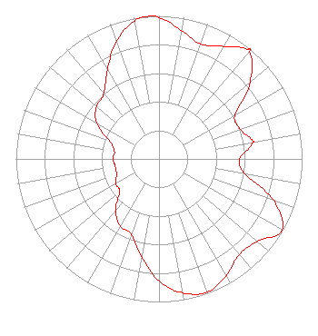 | |||||||||||||||||||||||||||||||||||||||||||||||||||
| Azimuth | Ratio | Azimuth | Ratio | Azimuth | Ratio | Azimuth | Ratio | |||||||||||||||||||||||||||||||||||||||||||||
| 0 | 0.989 | 10 | 0.910 | 20 | 0.856 | 30 | 0.907 | |||||||||||||||||||||||||||||||||||||||||||||
| 39 | 0.985 | 40 | 0.984 | 50 | 0.831 | 60 | 0.614 | |||||||||||||||||||||||||||||||||||||||||||||
| 70 | 0.602 | 79 | 0.666 | 80 | 0.665 | 90 | 0.564 | |||||||||||||||||||||||||||||||||||||||||||||
| 100 | 0.609 | 110 | 0.852 | 120 | 0.992 | 130 | 0.897 | |||||||||||||||||||||||||||||||||||||||||||||
| 140 | 0.873 | 150 | 0.940 | 160 | 0.992 | 170 | 0.952 | |||||||||||||||||||||||||||||||||||||||||||||
| 180 | 0.854 | 190 | 0.695 | 200 | 0.561 | 210 | 0.543 | |||||||||||||||||||||||||||||||||||||||||||||
| 220 | 0.474 | 230 | 0.358 | 240 | 0.348 | 250 | 0.316 | |||||||||||||||||||||||||||||||||||||||||||||
| 260 | 0.310 | 270 | 0.322 | 280 | 0.316 | 290 | 0.368 | |||||||||||||||||||||||||||||||||||||||||||||
| 300 | 0.504 | 310 | 0.570 | 320 | 0.598 | 330 | 0.722 | |||||||||||||||||||||||||||||||||||||||||||||
| 340 | 0.872 | 350 | 0.979 | 356 | 1.000 | |||||||||||||||||||||||||||||||||||||||||||||||
Structure Registration Number 1046244 Structure Type: GTOWER Registered To: Gray Media Group, Inc. Structure Address: 3 Miles West Blanchard, ND County Name: Traill County ASR Issued: 09/09/2020 Date Built: 08/13/1963 Site Elevation: 297.2 m (975 ft.) Structure Height: 605.6 m (1987 ft.) Height Overall: 605.6 m (1987 ft.) Overall Height AMSL: 902.8 m (2962 ft.) FAA Determination: 10/02/2019 FAA Study #: 2019-AGL-11540-OE FAA Circular #: 70/7460-1L Paint & Light FAA Chapters: 3, 4, 5, 12 PRIOR STUDY 2018-AGL-15816-OE 47-20-32.0 N 97-17-21.0 W (NAD 83) 47-20-32.1 N 97-17-19.7 W (Converted to NAD 27) |
1350 21st Ave South Fargo, ND 58103 Phone: 701-893-7569 Limited Liability Company | Title: Assistant Secretary Date: 10/29/2021 Application Certifier GRAY TELEVISION LICENSEE, LLC Gray Television Licensee, Llc 4370 Peachtree Rd Ne Atlanta, GA 30319 Applicant Joseph M. Davis, P.E. Chesapeake Rf Consultants, Llc 207 Old Dominion Road Yorktown, VA 23692 Consulting Engineer Joan Stewart Wiley Rein Llp 1776 K Street, N.w. Washington, DC 20006 | ||||||||||||||||||||||||||||||||||||||||||||||||||
|
| |||||||||||||||||||||||||||||||||||||||||||||||||||