
FCCInfo.com
A Service of Cavell, Mertz & Associates, Inc.
(855) FCC-INFO
|
|
WDCN-LD from 07/02/2008 WDCN-LD from 04/27/2007 WDCN-LD from 05/28/1992 WDCN-LD from 03/19/1992 WDCN-LD from 05/31/1989 |
|
|
|||||||||||||||||||
|
|
Status: STA – Special Temporary Authority Application Accepted: 11/04/2021 STA Expires: 00/00/0000 File Number: -0000166143 FCC Website Links: LMS Facility Details This Application Other WDCN-LD Applications Including Superseded Applications Mailing Address Correspondence for WDCN-LD Correspondence related to application -0000166143 Service Contour - Open Street Map or USGS Map (43 dBu) Service Contour - KML / Google Earth (43 dBu) Rabbit Ears Info Search for WDCN-LD Site Location: 38-52-28.2 N 77-13-23.6 W (NAD 83) Site Location: 38-52-27.8 N 77-13-24.7 W (Converted to NAD 27) ERP: 3 kW Polarization: Circularly polarized Electrical Beam Tilt: 0.5 degrees R/C AGL: 169.7 m (557 ft.) R/C AMSL: 280 m (919 ft.) Emission Mask: Full Service Site Elevation: 110.3 m. (362 ft.) Height Overall*: 210 m (689 ft.) (* As Filed In This Application, may differ from ASR Data, Below.) Directional Antenna - Antenna Make/Model: Propagation System Inc PSILV5CLOG-6 CUSTOM Antenna ID: 1008887 Polarization: Circularly polarized | |||||||||||||||||||||
| Antenna Data for Antenna Id: 1008887 WDCN-LD LD File: -0000166143 Propagation System Inc - PSILV5CLOG-6 CUSTOM Service: LD Standard Pattern: N Pattern and Field Values Include a 210° Clockwise Rotation | 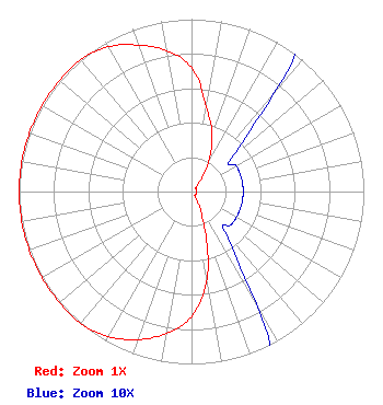 | |||||||||||||||||||||
| Azimuth | Ratio | Azimuth | Ratio | Azimuth | Ratio | Azimuth | Ratio | |||||||||||||||
| 0 | 0.720 | 10 | 0.500 | 20 | 0.350 | 30 | 0.200 | |||||||||||||||
| 40 | 0.075 | 50 | 0.030 | 60 | 0.030 | 70 | 0.030 | |||||||||||||||
| 80 | 0.030 | 90 | 0.030 | 100 | 0.030 | 110 | 0.030 | |||||||||||||||
| 120 | 0.030 | 130 | 0.030 | 140 | 0.030 | 150 | 0.075 | |||||||||||||||
| 160 | 0.219 | 170 | 0.514 | 180 | 0.727 | 190 | 0.835 | |||||||||||||||
| 200 | 0.914 | 210 | 0.970 | 220 | 1.000 | 230 | 1.000 | |||||||||||||||
| 240 | 1.000 | 250 | 1.000 | 260 | 1.000 | 270 | 1.000 | |||||||||||||||
| 280 | 1.000 | 290 | 1.000 | 300 | 1.000 | 310 | 1.000 | |||||||||||||||
| 320 | 1.000 | 330 | 0.970 | 340 | 0.904 | 350 | 0.830 | |||||||||||||||
Structure Registration Number 1017638 Structure Type: GTOWER Registered To: SBA Towers VIII, LLC Structure Address: 8101 A Lee Highway (va15666-a) Falls Church, VA County Name: Fairfax County ASR Issued: 06/29/2023 Date Built: 04/01/1983 Site Elevation: 110 m (361 ft.) Structure Height: 188.4 m (618 ft.) Height Overall: 210 m (689 ft.) Overall Height AMSL: 320 m (1050 ft.) FAA Determination: 01/12/2023 FAA Study #: 2022-AEA-1729-OE FAA Circular #: 70/7460-1L Paint & Light FAA Chapters: 4, 8, 12 OM&L to remain the same as prior studies = A MED-DUAL SYSTEM 38-52-28.2 N 77-13-23.6 W (NAD 83) 38-52-27.8 N 77-13-24.7 W (Converted to NAD 27) |
1945 Old Gallows Road Suite 650 Tysons, VA 22182 Phone: 703-761-5013 Limited Liability Company | Title: Member Date: 11/04/2021 Application Certifier SIGNAL ABOVE LLC Signal Above Llc 6139 Franklin Park Road Mclean, VA 22101 Applicant Clarence M. Beverage M. Beverage Communications Technologies, Inc. 23 Binsted Drive Medford, NJ 08055 Ari Meltzer Meltzer Wiley Rein Llp 1776 K Street Nw Washington, DC 20006 | ||||||||||||||||||||
| ||||||||||||||||||||||
