
FCCInfo.com
A Service of Cavell, Mertz & Associates, Inc.
(855) FCC-INFO
|
|
|
|
|
||||||||||||||||
|
|
Status: Construction Permit Application Accepted: 08/09/2022 K12XV-D CP Expires: 03/24/2026 File Number: BNPDVL-20090825AAU Prefix Type: This is BNPDVL FCC Website Links: LMS Facility Details This Application Other K12XV-D Applications Including Superseded Applications Mailing Address Correspondence for K12XV-D Correspondence related to application BNPDVL-20090825AAU Service Contour - Open Street Map or USGS Map (48 dBu) Service Contour - KML / Google Earth (48 dBu) Rabbit Ears Info Search for K12XV-D Site Location: 48-40-49.4 N 122-50-26.4 W (NAD 83) Site Location: 48-40-50.0 N 122-50-21.7 W (Converted to NAD 27) ERP: 3 kW Polarization: Elliptically polarized Electrical Beam Tilt: 1 degree R/C AGL: 30 m (98 ft.) R/C AMSL: 722 m (2369 ft.) Emission Mask: Full Service Site Elevation: 692 m. (2270 ft.) Height Overall*: 152 m (499 ft.) (* As Filed In This Application, may differ from ASR Data, Below.) Directional Antenna - Antenna Make/Model: ATC ATC-BCE42CWS-V3-12 Antenna ID: 1009899 Polarization: Elliptically polarized | ||||||||||||||||||
| Antenna Data for Antenna Id: 1009899 K12XV-D LD File: BNPDVL-20090825AAU ATC - ATC-BCE42CWS-V3-12 Service: LD Standard Pattern: N | 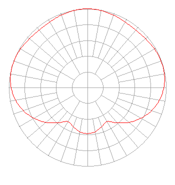 | ||||||||||||||||||
| Azimuth | Ratio | Azimuth | Ratio | Azimuth | Ratio | Azimuth | Ratio | ||||||||||||
| 0 | 1.000 | 10 | 0.992 | 20 | 0.977 | 30 | 0.959 | ||||||||||||
| 40 | 0.951 | 50 | 0.962 | 60 | 0.981 | 70 | 0.993 | ||||||||||||
| 80 | 0.990 | 90 | 0.970 | 100 | 0.928 | 110 | 0.865 | ||||||||||||
| 120 | 0.783 | 130 | 0.689 | 140 | 0.586 | 150 | 0.500 | ||||||||||||
| 160 | 0.530 | 170 | 0.570 | 180 | 0.585 | 190 | 0.570 | ||||||||||||
| 200 | 0.530 | 210 | 0.500 | 220 | 0.586 | 230 | 0.689 | ||||||||||||
| 240 | 0.783 | 250 | 0.865 | 260 | 0.928 | 270 | 0.970 | ||||||||||||
| 280 | 0.990 | 290 | 0.993 | 300 | 0.981 | 310 | 0.962 | ||||||||||||
| 320 | 0.951 | 330 | 0.959 | 340 | 0.977 | 350 | 0.992 | ||||||||||||
Structure Registration Number 1251758 Structure Type: Registered To: Mt. Constitution Sites Inc Structure Address: Aprox 1/2 Mile West Of Summit Of Mt Constitution, Orcas Island Eastsound, WA County Name: San Juan County ASR Issued: 02/09/2022 Date Built: 07/14/2006 Site Elevation: 692 m (2270 ft.) Structure Height: 152 m (499 ft.) Height Overall: 152 m (499 ft.) Overall Height AMSL: 844 m (2769 ft.) FAA Determination: 06/14/2005 FAA Study #: 2003-ANM-2385-OE FAA Circular #: 70/7460-1K Paint & Light FAA Chapters: 3, 4, 5, 12 PRIOR STUDY 2003-ANM-1341-OE 48-40-49.4 N 122-50-26.4 W (NAD 83) 48-40-50.0 N 122-50-21.7 W (Converted to NAD 27) |
1500 Cotner Avenue Los Angeles, CA 90025 Phone: 310-478-5540 Corporation | Title: President And General Manager Date: 08/09/2022 Application Certifier Mount Wilson Fm Broadcasters, Inc. 1500 Cotner Avenue Los Angeles, CA 90025 Applicant David D Oxenford Wilkinson Barker Knauer, Llp 1800 M Street, Nw Suite 800n Washington, DC 20036 Clarence M. Beverage Communications Technologies, Inc. 23 Binsted Drive Medford, NJ 08055 Broadcast Engineering Consultant | |||||||||||||||||