
FCCInfo.com
A Service of Cavell, Mertz & Associates, Inc.
(855) FCC-INFO
|
|
WGOX-LD from 03/09/2007 WGOX-LD from 04/22/2003 |
|
|
||||||||||||||||
|
|
Status: License Application Accepted: 11/18/2021 License Expires: 04/02/2029 File Number: -0000169489 FCC Website Links: LMS Facility Details This Application Other WGOX-LD Applications Including Superseded Applications Mailing Address Correspondence for WGOX-LD Correspondence related to application -0000169489 Service Contour - Open Street Map or USGS Map (51 dBu) Service Contour - KML / Google Earth (51 dBu) Rabbit Ears Info Search for WGOX-LD Site Location: 30-40-46.0 N 87-50-24.0 W (NAD 83) Site Location: 30-40-45.3 N 87-50-24.0 W (Converted to NAD 27) ERP: 15 kW Polarization: Elliptically polarized Electrical Beam Tilt: 1.0 degree R/C AGL: 103.2 m (339 ft.) R/C AMSL: 162.6 m (533 ft.) Emission Mask: Full Service Site Elevation: 59.4 m. (195 ft.) Height Overall*: 256.1 m (840 ft.) (* As Filed In This Application, may differ from ASR Data, Below.) Directional Antenna - Antenna Make/Model: Propagation System Inc PSILP-8EAC-36-EP Antenna ID: 1008941 Polarization: Elliptically polarized | ||||||||||||||||||
| Antenna Data for Antenna Id: 1008941 WGOX-LD LD File: -0000169489 Propagation System Inc - PSILP-8EAC-36-EP Service: LD Standard Pattern: N Pattern and Field Values Include a 280° Clockwise Rotation | 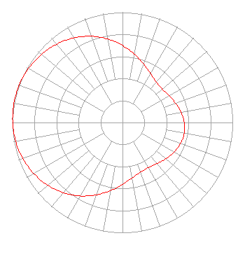 | ||||||||||||||||||
| Azimuth | Ratio | Azimuth | Ratio | Azimuth | Ratio | Azimuth | Ratio | ||||||||||||
| 0 | 0.699 | 10 | 0.629 | 20 | 0.562 | 30 | 0.510 | ||||||||||||
| 40 | 0.478 | 50 | 0.472 | 60 | 0.486 | 70 | 0.512 | ||||||||||||
| 80 | 0.539 | 90 | 0.559 | 100 | 0.568 | 110 | 0.559 | ||||||||||||
| 120 | 0.539 | 130 | 0.512 | 140 | 0.486 | 150 | 0.472 | ||||||||||||
| 160 | 0.478 | 170 | 0.510 | 180 | 0.562 | 190 | 0.629 | ||||||||||||
| 200 | 0.699 | 210 | 0.769 | 220 | 0.832 | 230 | 0.885 | ||||||||||||
| 240 | 0.928 | 250 | 0.961 | 260 | 0.984 | 270 | 0.996 | ||||||||||||
| 280 | 1.000 | 290 | 0.996 | 300 | 0.984 | 310 | 0.961 | ||||||||||||
| 320 | 0.928 | 330 | 0.885 | 340 | 0.832 | 350 | 0.769 | ||||||||||||
Structure Registration Number 1037340 Structure Type: GTOWER Registered To: Clearview Tower Company II, LLC Structure Address: End Of One Horse Rd N Of Hwy 31 Spanish Fort, AL County Name: Baldwin County ASR Issued: 10/20/2017 Date Built: 09/01/1980 Site Elevation: 59.4 m (195 ft.) Structure Height: 255.5 m (838 ft.) Height Overall: 256.1 m (840 ft.) Overall Height AMSL: 315.5 m (1035 ft.) FAA Determination: 12/08/1997 FAA Study #: 1997-ASO-6221-OE FAA Circular #: 70/7460-1J Paint & Light FAA Chapters: 3, 4, 5, 13 PREVIOUS STUDY #78-SO-1222-OE REF STUDY #96-ASO-4461-OE. 30-40-46.0 N 87-50-24.0 W (NAD 83) 30-40-45.3 N 87-50-24.0 W (Converted to NAD 27) |
351 S. Craft Hwy. Chickasaw, AL 76611 Phone: 251-456-2654 Not-for-Profit | Title: President Date: 11/18/2021 Application Certifier HENRY W. ROBERTS MINISTRIES Henry W. Roberts Ministries 351 S. Craft Hwy. Chickasaw, AL 76611 Applicant Susan Hansen B. W. St. Clair 2305 Vida Shaw Rd. New Iberia, LA 70563 CONSULTANT | |||||||||||||||||