
FCCInfo.com
A Service of Cavell, Mertz & Associates, Inc.
(855) FCC-INFO
|
|
|
|
|
||||||||||||||||
|
|
Status: Construction Permit Application Accepted: 11/26/2021 K35MF-D CP Expires: 12/02/2024 File Number: -0000171585 FCC Website Links: LMS Facility Details This Application Other K35MF-D Applications Including Superseded Applications Mailing Address Correspondence for K35MF-D Correspondence related to application -0000171585 Service Contour - Open Street Map or USGS Map (51 dBu) Service Contour - KML / Google Earth (51 dBu) Rabbit Ears Info Search for K35MF-D Site Location: 32-13-18.2 N 101-27-34.8 W (NAD 83) Site Location: 32-13-17.8 N 101-27-33.4 W (Converted to NAD 27) ERP: 12.5 kW Polarization: Elliptically polarized R/C AGL: 99 m (325 ft.) R/C AMSL: 940.2 m (3085 ft.) Emission Mask: Full Service Site Elevation: 841.2 m. (2760 ft.) Height Overall*: 108.2 m (355 ft.) (* As Filed In This Application, may differ from ASR Data, Below.) Directional Antenna - Antenna Make/Model: DIELECTRIC DLP-8B Antenna ID: 100585 Polarization: Elliptically polarized | ||||||||||||||||||
| Antenna Data for Antenna Id: 100585 K35MF-D LD File: -0000171585 DIELECTRIC - DLP-8B Service: LD Standard Pattern: Y Pattern and Field Values Include a 80° Clockwise Rotation | 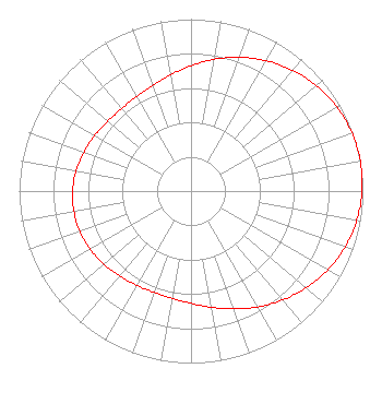 | ||||||||||||||||||
| Azimuth | Ratio | Azimuth | Ratio | Azimuth | Ratio | Azimuth | Ratio | ||||||||||||
| 0 | 0.729 | 10 | 0.778 | 20 | 0.828 | 30 | 0.875 | ||||||||||||
| 40 | 0.918 | 50 | 0.953 | 60 | 0.979 | 70 | 0.995 | ||||||||||||
| 80 | 1.000 | 90 | 0.995 | 100 | 0.979 | 110 | 0.953 | ||||||||||||
| 120 | 0.918 | 130 | 0.875 | 140 | 0.828 | 150 | 0.778 | ||||||||||||
| 160 | 0.729 | 170 | 0.686 | 180 | 0.653 | 190 | 0.633 | ||||||||||||
| 200 | 0.627 | 210 | 0.632 | 220 | 0.646 | 230 | 0.662 | ||||||||||||
| 240 | 0.678 | 250 | 0.689 | 260 | 0.692 | 270 | 0.689 | ||||||||||||
| 280 | 0.678 | 290 | 0.662 | 300 | 0.646 | 310 | 0.632 | ||||||||||||
| 320 | 0.627 | 330 | 0.633 | 340 | 0.653 | 350 | 0.686 | ||||||||||||
Structure Registration Number 1040261 Structure Type: GTOWER Registered To: American Towers LLC Structure Address: 12 Highland Cove Big Spring, TX County Name: Howard County ASR Issued: 01/05/2021 Date Built: 10/11/1967 Site Elevation: 841.2 m (2760 ft.) Structure Height: 103.6 m (340 ft.) Height Overall: 108.2 m (355 ft.) Overall Height AMSL: 949.4 m (3115 ft.) FAA Determination: 05/22/2013 FAA Study #: 2013-ASW-2635-OE Paint & Light FAA Chapters: 1, 3, 12, 21 PRIOR STUDY 1980-ASW-467-OE 32-13-18.2 N 101-27-34.8 W (NAD 83) 32-13-17.8 N 101-27-33.4 W (Converted to NAD 27) |
Hurst, TX 76054 Phone: 972-291-3750 Limited Liability Company | Title: Member/manager Date: 11/26/2021 Application Certifier EICB-TV EAST, LLC Eicb-tv East, Llc Hurst, TX 76054 Applicant Susan Hansen B. W. St. Clair 2305 Vida Shaw Rd. New Iberia, LA 70563 Consultant Randall Weiss Eicb-tv East, Llc Hurst, TX 76054 | |||||||||||||||||