
FCCInfo.com
A Service of Cavell, Mertz & Associates, Inc.
(855) FCC-INFO
|
|
|
|
|
||||||||||||||||
|
|
Status: License Application Accepted: 12/03/2021 License Expires: 08/01/2029 File Number: -0000176762 FCC Website Links: LMS Facility Details This Application Other WZDS-LD Applications Including Superseded Applications Mailing Address Correspondence for WZDS-LD Correspondence related to application -0000176762 Service Contour - Open Street Map or USGS Map (51 dBu) Service Contour - KML / Google Earth (51 dBu) Rabbit Ears Info Search for WZDS-LD Site Location: 37-53-17.2 N 87-32-37.0 W (NAD 83) Site Location: 37-53-17.0 N 87-32-37.0 W (Converted to NAD 27) ERP: 15 kW Polarization: Horizontally polarized Electrical Beam Tilt: 1.0 degree R/C AGL: 220 m (722 ft.) R/C AMSL: 345.9 m (1135 ft.) Emission Mask: Full Service Site Elevation: 125.9 m. (413 ft.) Height Overall*: 309.7 m (1016 ft.) (* As Filed In This Application, may differ from ASR Data, Below.) Directional Antenna - Antenna Make/Model: DIELECTRIC TFU-8DSB-M Antenna ID: 1008988 Polarization: Horizontally polarized | ||||||||||||||||||
| Antenna Data for Antenna Id: 1008988 WZDS-LD LD File: -0000176762 DIELECTRIC - TFU-8DSB-M Service: LD Standard Pattern: N | 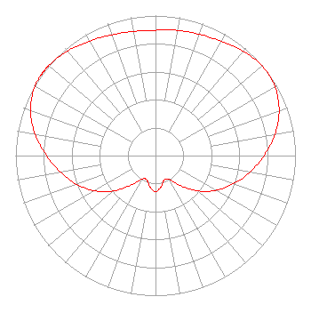 | ||||||||||||||||||
| Azimuth | Ratio | Azimuth | Ratio | Azimuth | Ratio | Azimuth | Ratio | ||||||||||||
| 0 | 0.895 | 10 | 0.908 | 20 | 0.921 | 30 | 0.942 | ||||||||||||
| 40 | 0.974 | 50 | 0.995 | 60 | 0.985 | 70 | 0.940 | ||||||||||||
| 80 | 0.865 | 90 | 0.775 | 100 | 0.684 | 110 | 0.593 | ||||||||||||
| 120 | 0.497 | 130 | 0.392 | 140 | 0.280 | 150 | 0.197 | ||||||||||||
| 160 | 0.184 | 170 | 0.226 | 180 | 0.257 | 190 | 0.227 | ||||||||||||
| 200 | 0.183 | 210 | 0.194 | 220 | 0.278 | 230 | 0.393 | ||||||||||||
| 240 | 0.502 | 250 | 0.599 | 260 | 0.688 | 270 | 0.778 | ||||||||||||
| 280 | 0.873 | 290 | 0.951 | 300 | 0.993 | 305 | 1.000 | ||||||||||||
| 306 | 1.000 | 307 | 1.000 | 308 | 1.000 | 310 | 0.998 | ||||||||||||
| 320 | 0.976 | 330 | 0.944 | 340 | 0.918 | 350 | 0.901 | ||||||||||||
Structure Registration Number 1030890 Structure Type: TOWER Registered To: Pinnacle Towers LLC Structure Address: Sr 414 E Of Us 41 Henderson, KY County Name: Henderson County ASR Issued: 05/06/2016 Date Built: 11/08/1993 Site Elevation: 125.9 m (413 ft.) Structure Height: 295 m (968 ft.) Height Overall: 309.7 m (1016 ft.) Overall Height AMSL: 435.6 m (1429 ft.) FAA Determination: 10/10/2008 FAA Study #: 2008-ASO-1595-OE FAA Circular #: 70/7460-1K Paint & Light FAA Chapters: 3, 4, 5, 12 OM&L to remain the same as prior study = PAINT/RED LIGHTS 37-53-17.2 N 87-32-37.0 W (NAD 83) 37-53-17.0 N 87-32-37.0 W (Converted to NAD 27) |
26 North Halsted Street Chicago, IL 60661 Phone: 312-705-2600 Corporation | Title: Director, President, Secretary And Treasurer Date: 12/03/2021 Application Certifier Tv-49, Inc. 26 North Halsted Street Chicago, IL 60661 Applicant Matthew S. DelNero Covington & Burling Llp One Citycenter 850 Tenth Street, Nw Washington, DC 20001 Legal Counsel Louis R duTreil, Jr Dutreil Lundin & Rackley Inc 5212 Station Way Sarasota, FL 34233 Technical Consultant | |||||||||||||||||