
FCCInfo.com
A Service of Cavell, Mertz & Associates, Inc.
(855) FCC-INFO
|
|
WRAP-LD from 08/07/2002 WRAP-LD from 02/21/1997 WRAP-LD from 03/28/1994 WRAP-LD from 12/16/1993 WRAP-LD from 05/11/1992 |
|
|
||||||||||||||||
|
|
Status: License Application Accepted: 12/06/2021 License Expires: 10/01/2021 File Number: -0000176891 FCC Website Links: LMS Facility Details This Application Other WRAP-LD Applications Including Superseded Applications Mailing Address Correspondence for WRAP-LD Correspondence related to application -0000176891 Service Contour - Open Street Map or USGS Map (51 dBu) Service Contour - KML / Google Earth (51 dBu) Rabbit Ears Info Search for WRAP-LD Site Location: 41-23-02.0 N 81-41-43.0 W (NAD 83) Site Location: 41-23-01.8 N 81-41-43.5 W (Converted to NAD 27) ERP: 15 kW Polarization: Elliptically polarized Electrical Beam Tilt: 1.0 degree R/C AGL: 207.3 m (680 ft.) R/C AMSL: 487.1 m (1598 ft.) Emission Mask: Full Service Site Elevation: 279.8 m. (918 ft.) Height Overall*: 344.7 m (1131 ft.) (* As Filed In This Application, may differ from ASR Data, Below.) Directional Antenna - Antenna Make/Model: Alive ATC-BCE416CP-V1-16 Antenna ID: 1008994 Polarization: Elliptically polarized | ||||||||||||||||||
| Antenna Data for Antenna Id: 1008994 WRAP-LD LD File: -0000176891 Alive - ATC-BCE416CP-V1-16 Service: LD Standard Pattern: N Pattern and Field Values Include a 100° Clockwise Rotation | 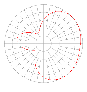 | ||||||||||||||||||
| Azimuth | Ratio | Azimuth | Ratio | Azimuth | Ratio | Azimuth | Ratio | ||||||||||||
| 0 | 0.602 | 10 | 0.753 | 20 | 0.866 | 30 | 0.941 | ||||||||||||
| 40 | 0.983 | 50 | 0.999 | 53 | 1.000 | 60 | 0.996 | ||||||||||||
| 70 | 0.982 | 80 | 0.962 | 90 | 0.944 | 100 | 0.933 | ||||||||||||
| 110 | 0.948 | 120 | 0.968 | 130 | 0.986 | 140 | 0.998 | ||||||||||||
| 150 | 0.997 | 160 | 0.979 | 170 | 0.937 | 180 | 0.863 | ||||||||||||
| 190 | 0.749 | 200 | 0.598 | 210 | 0.443 | 220 | 0.328 | ||||||||||||
| 230 | 0.293 | 240 | 0.342 | 250 | 0.441 | 260 | 0.554 | ||||||||||||
| 270 | 0.648 | 280 | 0.686 | 290 | 0.646 | 300 | 0.551 | ||||||||||||
| 310 | 0.438 | 320 | 0.339 | 330 | 0.292 | 340 | 0.329 | ||||||||||||
| 350 | 0.446 | ||||||||||||||||||
Structure Registration Number 1012028 Structure Type: TOWER Registered To: K2 Towers II, LLC Structure Address: 2855 W Ridgewood Dr Parma, OH County Name: Cuyahoga County ASR Issued: 10/13/2022 Date Built: 03/30/1993 Site Elevation: 279.8 m (918 ft.) Structure Height: 343.8 m (1128 ft.) Height Overall: 344.7 m (1131 ft.) Overall Height AMSL: 624.5 m (2049 ft.) FAA Determination: 01/09/1992 FAA Study #: 90-AGL-1665-OE FAA Circular #: 70/7460-1H Paint & Light FAA Chapters: 3, 4, 5, 13 41-23-02.0 N 81-41-43.0 W (NAD 83) 41-23-01.8 N 81-41-43.5 W (Converted to NAD 27) |
4604 49th St N, #148 St Petersburg, FL 33709 Phone: 877-688-8954 Limited Liability Company | Title: Llc Member Date: 12/06/2021 Application Certifier Wbc. Llc 2232 Dell Range Blvd, Ste 285 Cheyenne, WY 82009 Applicant Kevin T. Fisher Smith And Fisher Llc 4791 Wintergreen Court Woodbridge, VA 22192 Engineering Consultant Kathleen Victory Fletcher Heald And Hildreth Plc 1300 N. 17th St. 11th Floor Arlington, VA 22209 Legal Counsel RANDOLPH WEIGNER D.t.v. Llc 2232 Dell Range Blvd, Ste 285 Cheyenne, WY 82009 LLC MEMBER | |||||||||||||||||