
FCCInfo.com
A Service of Cavell, Mertz & Associates, Inc.
(855) FCC-INFO
|
|
WNAL-LD from 10/26/2017 WNAL-LD from 03/24/2006 WNAL-LD from 09/20/1989 |
|
|
|||||||||||||||||
|
|
Status: License Application Accepted: 12/27/2021 License Expires: 04/01/2021 File Number: -0000177983 FCC Website Links: LMS Facility Details This Application Other WNAL-LD Applications Including Superseded Applications Mailing Address Correspondence for WNAL-LD Correspondence related to application -0000177983 Service Contour - Open Street Map or USGS Map (51 dBu) Service Contour - KML / Google Earth (51 dBu) Rabbit Ears Info Search for WNAL-LD Site Location: 34-44-12.8 N 86-31-58.9 W (NAD 83) Site Location: 34-44-12.5 N 86-31-58.9 W (Converted to NAD 27) ERP: 9 kW Polarization: Horizontally polarized Electrical Beam Tilt: 0.5 degrees R/C AGL: 156.9 m (515 ft.) R/C AMSL: 630 m (2067 ft.) Emission Mask: Full Service Site Elevation: 473.1 m. (1552 ft.) Height Overall*: 305.4 m (1002 ft.) (* As Filed In This Application, may differ from ASR Data, Below.) Directional Antenna - Antenna Make/Model: Propagation System Inc PSILP8AD(MOD) Antenna ID: 1009082 Polarization: Horizontally polarized
| |||||||||||||||||||
| Antenna Data for Antenna Id: 1009082 WNAL-LD LD File: -0000177983 Propagation System Inc - PSILP8AD(MOD) Service: LD Standard Pattern: N Pattern and Field Values Include a 276° Clockwise Rotation | 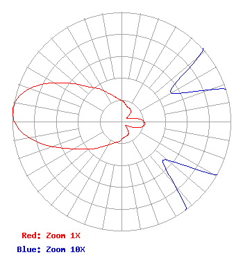 | |||||||||||||||||||
| Azimuth | Ratio | Azimuth | Ratio | Azimuth | Ratio | Azimuth | Ratio | |||||||||||||
| 6 | 0.182 | 16 | 0.154 | 26 | 0.142 | 36 | 0.138 | |||||||||||||
| 46 | 0.115 | 56 | 0.056 | 66 | 0.065 | 76 | 0.124 | |||||||||||||
| 86 | 0.190 | 96 | 0.213 | 106 | 0.190 | 116 | 0.124 | |||||||||||||
| 126 | 0.065 | 136 | 0.056 | 146 | 0.115 | 156 | 0.138 | |||||||||||||
| 166 | 0.142 | 176 | 0.154 | 186 | 0.182 | 196 | 0.200 | |||||||||||||
| 206 | 0.230 | 216 | 0.280 | 226 | 0.360 | 236 | 0.445 | |||||||||||||
| 246 | 0.595 | 256 | 0.786 | 266 | 0.943 | 276 | 1.000 | |||||||||||||
| 286 | 0.943 | 296 | 0.786 | 306 | 0.595 | 316 | 0.445 | |||||||||||||
| 326 | 0.360 | 336 | 0.280 | 346 | 0.230 | 356 | 0.200 | |||||||||||||
Structure Registration Number 1041008 Structure Type: GTOWER Registered To: American Towers, LLC Structure Address: 1000 Monte Sano Boulevard (#300152) Huntsville, AL County Name: Madison County ASR Issued: 02/07/2020 Date Built: 12/01/1977 Site Elevation: 473.1 m (1552 ft.) Structure Height: 274.3 m (900 ft.) Height Overall: 305.4 m (1002 ft.) Overall Height AMSL: 778.5 m (2554 ft.) FAA Determination: 04/24/2015 FAA Study #: 2015-ASO-2844-OE FAA Circular #: 70/7460-1K Paint & Light FAA Chapters: 4, 9, 12 OM&L to remain the same as prior study = A HIGH-DUAL SYSTEM 34-44-12.8 N 86-31-58.9 W (NAD 83) 34-44-12.5 N 86-31-58.9 W (Converted to NAD 27)  American Tower Corporation 300152 - Huntsville 1008 |
Chattanooga, TN 37401 Phone: 423-468-5100 Limited Liability Company | Title: Coo Date: 12/27/2021 Application Certifier DIGITAL NETWORKS-SOUTHEAST, LLC Digital Networks-southeast, Llc Chattanooga, TN 37401 Applicant Timothy Z Sawyer T Z Sawyer Technical Consultants 2130 Hutchison Grove Court Suite 100 Falls Church, VA 22043 Technical Consultant Aaron P Shainis, Esq Shainis & Peltzman Chartered 1850 M Street Nw Suite 240 Washington, DC 20036 Attorney | ||||||||||||||||||