
FCCInfo.com
A Service of Cavell, Mertz & Associates, Inc.
(855) FCC-INFO
|
|
|
|
|
|||||||||||||||||
|
|
Status: License Application Accepted: 01/03/2022 License Expires: 02/01/2029 File Number: -0000178364 FCC Website Links: LMS Facility Details This Application Other W35DH-D Applications Including Superseded Applications Mailing Address Correspondence for W35DH-D Correspondence related to application -0000178364 Service Contour - Open Street Map or USGS Map (51 dBu) Service Contour - KML / Google Earth (51 dBu) Rabbit Ears Info Search for W35DH-D Site Location: 30-40-14.0 N 83-56-26.0 W (NAD 83) Site Location: 30-40-13.3 N 83-56-26.4 W (Converted to NAD 27) ERP: 10 kW Polarization: Horizontally polarized R/C AGL: 11 m (36 ft.) R/C AMSL: 78.6 m (258 ft.) Emission Mask: Stringent Site Elevation: 67.6 m. (222 ft.) Height Overall*: 609.6 m (2000 ft.) (* As Filed In This Application, may differ from ASR Data, Below.) Directional Antenna - Antenna Make/Model: ELTI ELTI UHF Panel Antenna ID: 1008435 Polarization: Horizontally polarized
| |||||||||||||||||||
| Antenna Data for Antenna Id: 1008435 W35DH-D LD File: -0000178364 ELTI - ELTI UHF Panel Service: LD Standard Pattern: Y Pattern and Field Values Include a 145° Clockwise Rotation | 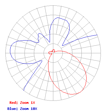 | |||||||||||||||||||
| Azimuth | Ratio | Azimuth | Ratio | Azimuth | Ratio | Azimuth | Ratio | |||||||||||||
| 5 | 0.073 | 15 | 0.074 | 25 | 0.072 | 35 | 0.060 | |||||||||||||
| 45 | 0.033 | 55 | 0.029 | 65 | 0.082 | 75 | 0.158 | |||||||||||||
| 85 | 0.263 | 95 | 0.389 | 105 | 0.537 | 115 | 0.700 | |||||||||||||
| 125 | 0.851 | 135 | 0.955 | 145 | 1.000 | 155 | 0.955 | |||||||||||||
| 165 | 0.851 | 175 | 0.700 | 185 | 0.531 | 195 | 0.367 | |||||||||||||
| 205 | 0.232 | 215 | 0.132 | 225 | 0.052 | 235 | 0.028 | |||||||||||||
| 245 | 0.053 | 255 | 0.075 | 265 | 0.087 | 275 | 0.090 | |||||||||||||
| 285 | 0.084 | 295 | 0.062 | 305 | 0.038 | 315 | 0.044 | |||||||||||||
| 325 | 0.050 | 335 | 0.033 | 345 | 0.025 | 355 | 0.056 | |||||||||||||
Structure Registration Number 1019981 Structure Type: TOWER Registered To: Gray Media Group, Inc. Structure Address: 30 Roddenberry Rd 3.5 Mi Sw Metcalf, GA County Name: Thomas County ASR Issued: 09/09/2020 Date Built: 01/01/1987 Site Elevation: 67.6 m (222 ft.) Structure Height: 587 m (1926 ft.) Height Overall: 609.6 m (2000 ft.) Overall Height AMSL: 677.2 m (2222 ft.) Paint & Light FAA Chapters: A1, B, G, H 30-40-14.0 N 83-56-26.0 W (NAD 83) 30-40-13.3 N 83-56-26.4 W (Converted to NAD 27) |
14 Tuxedo Drive Beaufort, SC 29907 Phone: 717-226-3535 Limited Liability Company | Title: Manager Date: 01/03/2022 Application Certifier Lowcountry 34 Media, Llc 14 Tuxedo Drive Beaufort, SC 29907 Applicant Davina Sashkin, Esq Baker & Hostetler Llp 1050 Connecticut Avenue, Nw Suite 1100 Washington, DC 20036 | ||||||||||||||||||