
FCCInfo.com
A Service of Cavell, Mertz & Associates, Inc.
(855) FCC-INFO
|
|
WKXT-LD from 01/08/2013 WKXT-LD from 01/11/2000 WKXT-LD from 05/03/1999 |
|
|
|||||||||||||||||
|
|
Status: Application (Licensed And Silent) Application Accepted: 01/03/2022 License Expires: 09/21/2021 File Number: -0000178491 FCC Website Links: LMS Facility Details This Application Other WKXT-LD Applications Including Superseded Applications Mailing Address Correspondence for WKXT-LD Correspondence related to application -0000178491 Service Contour - Open Street Map or USGS Map (51 dBu) Service Contour - KML / Google Earth (51 dBu) Rabbit Ears Info Search for WKXT-LD Site Location: 35-59-44.4 N 83-57-23.1 W (NAD 83) Site Location: 35-59-44.1 N 83-57-23.4 W (Converted to NAD 27) ERP: 15 kW Polarization: Horizontally polarized Electrical Beam Tilt: 1.0 degree R/C AGL: 184.2 m (604 ft.) R/C AMSL: 585 m (1919 ft.) Emission Mask: Full Service Site Elevation: 400.8 m. (1315 ft.) Height Overall*: 467.6 m (1534 ft.) (* As Filed In This Application, may differ from ASR Data, Below.) Directional Antenna - Antenna Make/Model: Propagation System Inc PSILP16EC Antenna ID: 1009112 Polarization: Horizontally polarized
| |||||||||||||||||||
| Antenna Data for Antenna Id: 1009112 WKXT-LD LD File: -0000178491 Propagation System Inc - PSILP16EC Service: LD Standard Pattern: N Pattern and Field Values Include a 140° Clockwise Rotation | 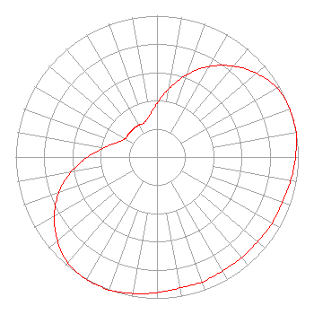 | |||||||||||||||||||
| Azimuth | Ratio | Azimuth | Ratio | Azimuth | Ratio | Azimuth | Ratio | |||||||||||||
| 0 | 0.380 | 10 | 0.490 | 20 | 0.620 | 30 | 0.740 | |||||||||||||
| 40 | 0.840 | 50 | 0.920 | 60 | 0.980 | 70 | 1.000 | |||||||||||||
| 80 | 1.000 | 90 | 0.980 | 100 | 0.960 | 110 | 0.940 | |||||||||||||
| 120 | 0.940 | 130 | 0.930 | 140 | 0.930 | 150 | 0.930 | |||||||||||||
| 160 | 0.940 | 170 | 0.940 | 180 | 0.960 | 190 | 0.980 | |||||||||||||
| 200 | 1.000 | 210 | 1.000 | 220 | 0.980 | 230 | 0.920 | |||||||||||||
| 240 | 0.840 | 250 | 0.740 | 260 | 0.620 | 270 | 0.490 | |||||||||||||
| 280 | 0.380 | 290 | 0.300 | 300 | 0.260 | 310 | 0.260 | |||||||||||||
| 320 | 0.260 | 330 | 0.260 | 340 | 0.260 | 350 | 0.300 | |||||||||||||
Structure Registration Number 1222895 Structure Type: GTOWER Registered To: American Towers LLC Structure Address: Location Is Approx. 0.25 Mi. S Of The I-75 / I-275 / I-640 Interchange Lonsdale, TN County Name: Knox County ASR Issued: 11/12/2018 Date Built: 04/03/2003 Site Elevation: 400.8 m (1315 ft.) Structure Height: 426.7 m (1400 ft.) Height Overall: 467.6 m (1534 ft.) Overall Height AMSL: 868.4 m (2849 ft.) FAA Determination: 11/07/2018 FAA Study #: 2018-ASO-6833-OE FAA Circular #: 70/7460-1K Paint & Light FAA Chapters: 4, 9, 12 OM&L to remain the same as prior study = A HIGH-DUAL SYSTEM 35-59-44.4 N 83-57-23.1 W (NAD 83) 35-59-44.1 N 83-57-23.4 W (Converted to NAD 27) |
Chattanooga, TN 37401 Phone: 423-468-5100 Limited Liability Company | Title: Coo Date: 01/03/2022 Application Certifier DIGITAL NETWORKS-SOUTHEAST, LLC Digital Networks-southeast, Llc Chattanooga, TN 37401 Applicant Timothy Z Sawyer T Z Sawyer Technical Consultants 2130 Hutchison Grove Court Suite 100 Falls Church, VA 22043 Technical Consultant Aaron P Shainis Shainis & Peltzman, Chartered 1850 M St. Nw Suite 240 Washington, DC 20036 FCC Legal Counsel | ||||||||||||||||||