
FCCInfo.com
A Service of Cavell, Mertz & Associates, Inc.
(855) FCC-INFO
|
|
WXSG-LD from 10/02/2012 |
|
|
||||||||||||||||
|
|
Status: License Application Accepted: 01/10/2022 License Expires: 12/03/2029 File Number: -0000179506 FCC Website Links: LMS Facility Details This Application Other WXSG-LD Applications Including Superseded Applications Mailing Address Correspondence for WXSG-LD Correspondence related to application -0000179506 Service Contour - Open Street Map or USGS Map (51 dBu) Service Contour - KML / Google Earth (51 dBu) Rabbit Ears Info Search for WXSG-LD Site Location: 39-49-32.0 N 89-38-12.0 W (NAD 83) Site Location: 39-49-31.8 N 89-38-11.6 W (Converted to NAD 27) ERP: 5.6 kW Polarization: Elliptically polarized Electrical Beam Tilt: 0.75 degrees R/C AGL: 28.9 m (95 ft.) R/C AMSL: 212.1 m (696 ft.) Emission Mask: Full Service Site Elevation: 183.2 m. (601 ft.) Height Overall*: 42.7 m (140 ft.) (* As Filed In This Application, may differ from ASR Data, Below.) Directional Antenna - Antenna Make/Model: ATC ATC-BCE38M-V3-27 Antenna ID: 1008207 Polarization: Elliptically polarized | ||||||||||||||||||
| Antenna Data for Antenna Id: 1008207 WXSG-LD LD File: -0000179506 ATC - ATC-BCE38M-V3-27 Service: LD Standard Pattern: N Pattern and Field Values Include a 180° Clockwise Rotation | 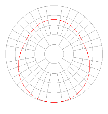 | ||||||||||||||||||
| Azimuth | Ratio | Azimuth | Ratio | Azimuth | Ratio | Azimuth | Ratio | ||||||||||||
| 0 | 0.709 | 10 | 0.705 | 20 | 0.694 | 30 | 0.678 | ||||||||||||
| 40 | 0.661 | 50 | 0.647 | 60 | 0.641 | 70 | 0.645 | ||||||||||||
| 80 | 0.663 | 90 | 0.694 | 100 | 0.734 | 110 | 0.781 | ||||||||||||
| 120 | 0.829 | 130 | 0.876 | 140 | 0.918 | 150 | 0.953 | ||||||||||||
| 160 | 0.979 | 170 | 0.995 | 180 | 1.000 | 190 | 0.995 | ||||||||||||
| 200 | 0.979 | 210 | 0.953 | 220 | 0.918 | 230 | 0.876 | ||||||||||||
| 240 | 0.829 | 250 | 0.781 | 260 | 0.734 | 270 | 0.694 | ||||||||||||
| 280 | 0.663 | 290 | 0.645 | 300 | 0.641 | 310 | 0.647 | ||||||||||||
| 320 | 0.661 | 330 | 0.679 | 340 | 0.694 | 350 | 0.705 | ||||||||||||
Structure Registration Number 1040108 Structure Type: TOWER Registered To: VB-S1 Assets, LLC Structure Address: Se Corner Of Griffith's Ave. And Factory Street Springfield, IL County Name: Sangamon County ASR Issued: 01/30/2018 Date Built: 08/19/1997 Site Elevation: 183.2 m (601 ft.) Structure Height: 39.6 m (130 ft.) Height Overall: 42.7 m (140 ft.) Overall Height AMSL: 225.9 m (741 ft.) FAA Determination: 08/05/1997 FAA Study #: 97-AGL-2717-OE Paint & Light FAA Chapters: NONE Removed expiration date from determination. Scenario 1./jjs/case#635066 39-49-32.0 N 89-38-12.0 W (NAD 83) 39-49-31.8 N 89-38-11.6 W (Converted to NAD 27) |
888c 8th Avenue Suite 733 New York, NY 10019 Phone: 212-580-1349 Limited Liability Company | Title: Member Date: 01/10/2022 Application Certifier Sagamorehill Of Kansas City Licenses Llc 888c 8th Avenue Suite 733 New York, NY 10019 Applicant Clarence M Beverage Communications Technologies, Inc. 23 Binsted Drive Medford, NJ 08055 Broadcast Engineering Consultant Aaron P Shainis Shainis & Peltzman, Chartered 1850 M St Nw Suite 240 Washington, DC 20036 Legal Counsel | |||||||||||||||||