
FCCInfo.com
A Service of Cavell, Mertz & Associates, Inc.
(855) FCC-INFO
|
|
KZFW-LD from 04/02/2007 KZFW-LD from 02/01/1995 KZFW-LD from 02/19/1993 KZFW-LD from 07/27/1984 |
|
|
||||||||||||||||
|
|
Status: License Application Accepted: 01/07/2022 License Expires: 08/01/2022 File Number: -0000179308 FCC Website Links: LMS Facility Details This Application Other KZFW-LD Applications Including Superseded Applications Mailing Address Correspondence for KZFW-LD Correspondence related to application -0000179308 Service Contour - Open Street Map or USGS Map (43 dBu) Service Contour - KML / Google Earth (43 dBu) Rabbit Ears Info Search for KZFW-LD Site Location: 32-35-20.0 N 96-58-05.9 W (NAD 83) Site Location: 32-35-19.5 N 96-58-04.9 W (Converted to NAD 27) ERP: 0.34 kW Polarization: Horizontally polarized R/C AGL: 440 m (1444 ft.) R/C AMSL: 683.8 m (2243 ft.) Emission Mask: Stringent Site Elevation: 243.8 m. (800 ft.) Height Overall*: 506.2 m (1661 ft.) (* As Filed In This Application, may differ from ASR Data, Below.) Directional Antenna - Antenna Make/Model: Scala CL-26 Antenna ID: 80646 Polarization: Horizontally polarized | ||||||||||||||||||
| Antenna Data for Antenna Id: 80646 KZFW-LD LD File: -0000179308 Scala - CL-26 Service: LD Standard Pattern: Y Pattern and Field Values Include a 45° Clockwise Rotation | 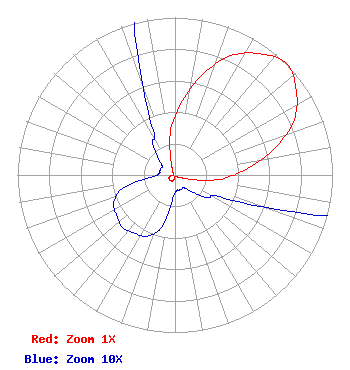 | ||||||||||||||||||
| Azimuth | Ratio | Azimuth | Ratio | Azimuth | Ratio | Azimuth | Ratio | ||||||||||||
| 5 | 0.460 | 15 | 0.655 | 25 | 0.835 | 35 | 0.940 | ||||||||||||
| 45 | 1.000 | 55 | 0.940 | 65 | 0.835 | 75 | 0.655 | ||||||||||||
| 85 | 0.460 | 95 | 0.295 | 105 | 0.105 | 115 | 0.035 | ||||||||||||
| 125 | 0.025 | 135 | 0.015 | 145 | 0.010 | 155 | 0.010 | ||||||||||||
| 165 | 0.010 | 175 | 0.010 | 185 | 0.015 | 195 | 0.035 | ||||||||||||
| 205 | 0.043 | 215 | 0.045 | 225 | 0.047 | 235 | 0.045 | ||||||||||||
| 245 | 0.043 | 255 | 0.035 | 265 | 0.015 | 275 | 0.010 | ||||||||||||
| 285 | 0.010 | 295 | 0.010 | 305 | 0.010 | 315 | 0.015 | ||||||||||||
| 325 | 0.025 | 335 | 0.035 | 345 | 0.105 | 355 | 0.295 | ||||||||||||
Structure Registration Number 1045531 Structure Type: GTOWER Registered To: American Towers LLC Structure Address: 1310 West Beltline Road (cowboy Tower/dallas #75256) Cedar Hill, TX County Name: Dallas County ASR Issued: 09/20/2023 Date Built: 09/19/2008 Site Elevation: 243.8 m (800 ft.) Structure Height: 480.7 m (1577 ft.) Height Overall: 506.2 m (1661 ft.) Overall Height AMSL: 750 m (2461 ft.) FAA Determination: 04/10/2023 FAA Study #: 2022-ASW-23640-OE FAA Circular #: 70/7460-1M Paint & Light FAA Chapters: 4, 9, 15 PRIOR STUDY 2005-ASW-25-OE 32-35-20.0 N 96-58-05.9 W (NAD 83) 32-35-19.5 N 96-58-04.9 W (Converted to NAD 27) |
1901 E. Centerville Rd. Garland, TX 75042 Phone: 972-487-1371 Not-for-Profit | Title: President Date: 01/07/2022 Application Certifier CENTRAL PARK CHURCH OF GOD, INC. Central Park Church Of God, Inc. 1901 E. Centerville Rd. Garland, TX 75042 Applicant Dan J Alpert The Law Office Of Dan J. Alpert 2120 N. 21st Rd. Arlington, VA 22201 Legal Counsel Darryl K DeLawder Delawder Communications, Inc. P.o. Box 1095 Ashburn, VA 20146 President | |||||||||||||||||