
FCCInfo.com
A Service of Cavell, Mertz & Associates, Inc.
(855) FCC-INFO
|
|
|
|
|
||||||||||||||||
|
|
Status: License Application Accepted: 01/10/2022 License Expires: 04/02/2029 File Number: -0000179315 FCC Website Links: LMS Facility Details This Application Other WAUT-LD Applications Including Superseded Applications Mailing Address Correspondence for WAUT-LD Correspondence related to application -0000179315 Service Contour - Open Street Map or USGS Map (51 dBu) Service Contour - KML / Google Earth (51 dBu) Rabbit Ears Info Search for WAUT-LD Site Location: 32-37-14.0 N 85-27-38.5 W (NAD 83) Site Location: 32-37-13.5 N 85-27-38.7 W (Converted to NAD 27) ERP: 4 kW Polarization: Horizontally polarized R/C AGL: 35 m (115 ft.) R/C AMSL: 259.3 m (851 ft.) Emission Mask: Full Service Site Elevation: 224.3 m. (736 ft.) Height Overall*: 36.5 m (120 ft.) (* As Filed In This Application, may differ from ASR Data, Below.) Directional Antenna - Antenna Make/Model: Systems With Reliability Inc. SWLP4OI Antenna ID: 1009152 Polarization: Horizontally polarized | ||||||||||||||||||
| Antenna Data for Antenna Id: 1009152 WAUT-LD LD File: -0000179315 Systems With Reliability Inc. - SWLP4OI Service: LD Standard Pattern: N Pattern and Field Values Include a 235° Clockwise Rotation | 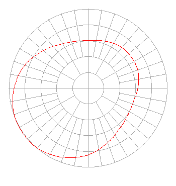 | ||||||||||||||||||
| Azimuth | Ratio | Azimuth | Ratio | Azimuth | Ratio | Azimuth | Ratio | ||||||||||||
| 5 | 0.600 | 15 | 0.620 | 25 | 0.640 | 35 | 0.660 | ||||||||||||
| 45 | 0.670 | 55 | 0.670 | 65 | 0.670 | 75 | 0.660 | ||||||||||||
| 85 | 0.640 | 95 | 0.620 | 105 | 0.600 | 115 | 0.600 | ||||||||||||
| 125 | 0.610 | 135 | 0.630 | 145 | 0.660 | 155 | 0.710 | ||||||||||||
| 165 | 0.760 | 175 | 0.820 | 185 | 0.870 | 195 | 0.910 | ||||||||||||
| 205 | 0.950 | 215 | 0.980 | 225 | 1.000 | 235 | 1.000 | ||||||||||||
| 245 | 1.000 | 255 | 0.980 | 265 | 0.950 | 275 | 0.910 | ||||||||||||
| 285 | 0.870 | 295 | 0.820 | 305 | 0.760 | 315 | 0.710 | ||||||||||||
| 325 | 0.660 | 335 | 0.630 | 345 | 0.610 | 355 | 0.600 | ||||||||||||
Structure Registration Number 1303435 Structure Type: LTOWER Registered To: Auburn Network Inc. Structure Address: 724 N Dean Road Suite 300 Auburn, AL County Name: Lee County ASR Issued: 09/19/2017 Date Built: 09/26/2017 Site Elevation: 224.3 m (736 ft.) Structure Height: 36.5 m (120 ft.) Height Overall: 36.5 m (120 ft.) Overall Height AMSL: 260.8 m (856 ft.) FAA Determination: 05/18/2017 FAA Study #: 2017-ASO-1342-OE Paint & Light FAA Chapters: NONE PRIOR STUDY 2016-ASO-22773-OE 32-37-14.0 N 85-27-38.5 W (NAD 83) 32-37-13.5 N 85-27-38.7 W (Converted to NAD 27) |
Hoschton, GA 30548 Phone: 334-703-1134 Individual | Title: Technical Consultant Date: 01/10/2022 Application Certifier 2428 Peace Point Trail Hoschton, GA 30548 Applicant Dale Howard Dale Howard & Associates 4949 Lakeridge Dr. Old Hickory, TN 37138 Richard C Goetz R & L Media Systems 135 N Country Club Dr Hendersonville, TN 37075 Broadcast Consultant | |||||||||||||||||