
FCCInfo.com
A Service of Cavell, Mertz & Associates, Inc.
(855) FCC-INFO
|
|
WYMI-LD from 10/07/2011 WYMI-LD from 08/05/2003 |
|
|
||||||||||||||||
|
|
Status: License Application Accepted: 01/10/2022 License Expires: 02/01/2029 File Number: -0000179379 FCC Website Links: LMS Facility Details This Application Other WYMI-LD Applications Including Superseded Applications Mailing Address Correspondence for WYMI-LD Correspondence related to application -0000179379 Service Contour - Open Street Map or USGS Map (51 dBu) Service Contour - KML / Google Earth (51 dBu) Rabbit Ears Info Search for WYMI-LD Site Location: 24-40-37.4 N 81-30-38.0 W (NAD 83) Site Location: 24-40-35.9 N 81-30-38.7 W (Converted to NAD 27) ERP: 15 kW Polarization: Horizontally polarized R/C AGL: 150 m (492 ft.) R/C AMSL: 151.2 m (496 ft.) Emission Mask: Full Service Site Elevation: 1.2 m. (4 ft.) Height Overall*: 185 m (607 ft.) (* As Filed In This Application, may differ from ASR Data, Below.) Directional Antenna - Antenna Make/Model: Andrew ALP16L2-HSNR Antenna ID: 45028 Polarization: Horizontally polarized | ||||||||||||||||||
| Antenna Data for Antenna Id: 45028 WYMI-LD LD File: -0000179379 Andrew - ALP16L2-HSNR Service: LD Standard Pattern: Y Pattern and Field Values Include a 240° Clockwise Rotation | 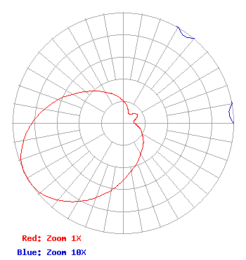 | ||||||||||||||||||
| Azimuth | Ratio | Azimuth | Ratio | Azimuth | Ratio | Azimuth | Ratio | ||||||||||||
| 0 | 0.200 | 10 | 0.170 | 20 | 0.130 | 30 | 0.100 | ||||||||||||
| 40 | 0.100 | 50 | 0.130 | 60 | 0.150 | 70 | 0.130 | ||||||||||||
| 80 | 0.100 | 90 | 0.100 | 100 | 0.130 | 110 | 0.170 | ||||||||||||
| 120 | 0.200 | 130 | 0.240 | 140 | 0.280 | 150 | 0.320 | ||||||||||||
| 160 | 0.380 | 170 | 0.440 | 180 | 0.520 | 190 | 0.620 | ||||||||||||
| 200 | 0.720 | 210 | 0.820 | 220 | 0.910 | 230 | 0.980 | ||||||||||||
| 240 | 1.000 | 250 | 0.980 | 260 | 0.910 | 270 | 0.820 | ||||||||||||
| 280 | 0.720 | 290 | 0.620 | 300 | 0.520 | 310 | 0.440 | ||||||||||||
| 320 | 0.380 | 330 | 0.320 | 340 | 0.280 | 350 | 0.240 | ||||||||||||
Structure Registration Number 1053369 Structure Type: GTOWER Registered To: Vertical Bridge CC FM, LLC Structure Address: Mm 23 Us 1 Off Blimp Rd Cudjoe Key, FL County Name: Monroe County ASR Issued: 03/22/2018 Date Built: 06/02/2012 Site Elevation: 1.2 m (4 ft.) Structure Height: 184 m (604 ft.) Height Overall: 185 m (607 ft.) Overall Height AMSL: 186.2 m (611 ft.) FAA Determination: 03/12/2018 FAA Study #: 2017-ASO-17876-OE FAA Circular #: 70/7460-1L Paint & Light FAA Chapters: 4, 8, 12 Removed expiration date from determination. Scenario 1./jjs/case#635066 24-40-37.4 N 81-30-38.0 W (NAD 83) 24-40-35.9 N 81-30-38.7 W (Converted to NAD 27) |
7812 W. Sage Creek Ct. Tuscon, AZ 85743 Phone: 520-971-9274 Corporation | Title: President Date: 01/10/2022 Application Certifier HOSANNA APOSTOLIC MINISTRIES BROADCASTING CORPORATION Hosanna Apostolic Ministries Broadcasting Corporation 7812 W. Sage Creek Ct. Tuscon, AZ 85743 Applicant Dan J Alpert The Law Office Of Dan J. Alpert 2120 N. 21st Rd. Arlington, VA 22201 Legal Counsel Darryl K DeLawder Delawder Communications, Inc. P.o. Box 1095 Ashburn, VA 20146 President | |||||||||||||||||