
FCCInfo.com
A Service of Cavell, Mertz & Associates, Inc.
(855) FCC-INFO
|
|
|
Virtual Channel 25 |  |
|
||||||||||||||||||||||||||||||||||||
|
|
Repacking Information: No changes Status: License Application Accepted: 02/15/2022 License Expires: 02/01/2029 File Number: -0000184852 FCC Website Links: LMS Facility Details This Application Other WPBF Applications Including Superseded Applications Mailing Address Correspondence for WPBF Correspondence related to application -0000184852 Service Contour - Open Street Map or USGS Map (41 dBu) Service Contour - KML / Google Earth (41 dBu) Public Inspection Files Rabbit Ears Info Search for WPBF Site Location: 27-07-19.0 N 80-23-41.0 W (NAD 83) Site Location: 27-07-17.8 N 80-23-41.8 W (Converted to NAD 27) ERP: 1000 kW Polarization: Elliptically polarized HAAT: 450.0 m (1476 ft.) Electrical Beam Tilt: 0.75 degrees R/C AGL: 449.7 m (1475 ft.) R/C AMSL: 458.5 m (1504 ft.) Site Elevation: 8.8 m. (29 ft.) Height Overall*: 458.4 m (1504 ft.) (* As Filed In This Application, may differ from ASR Data, Below.) Directional Antenna - Antenna Make/Model: DIELECTRIC TFU-22GTH/VP-R P260BNT Antenna ID: 1009291 Polarization: Elliptically polarized | |||||||||||||||||||||||||||||||||||||||
| Antenna Data for Antenna Id: 1009291 WPBF DT File: -0000184852 DIELECTRIC - TFU-22GTH/VP-R P260BNT Service: DT Standard Pattern: N | 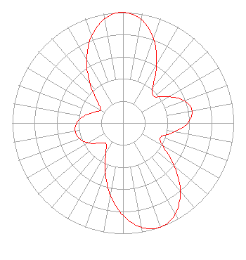 | |||||||||||||||||||||||||||||||||||||||
| Azimuth | Ratio | Azimuth | Ratio | Azimuth | Ratio | Azimuth | Ratio | |||||||||||||||||||||||||||||||||
| 0 | 1.000 | 10 | 0.949 | 20 | 0.808 | 30 | 0.608 | |||||||||||||||||||||||||||||||||
| 40 | 0.419 | 50 | 0.370 | 60 | 0.475 | 70 | 0.588 | |||||||||||||||||||||||||||||||||
| 80 | 0.632 | 90 | 0.588 | 100 | 0.473 | 110 | 0.365 | |||||||||||||||||||||||||||||||||
| 120 | 0.412 | 130 | 0.603 | 140 | 0.805 | 150 | 0.947 | |||||||||||||||||||||||||||||||||
| 160 | 1.000 | 170 | 0.957 | 180 | 0.835 | 190 | 0.660 | |||||||||||||||||||||||||||||||||
| 200 | 0.469 | 210 | 0.309 | 220 | 0.242 | 230 | 0.285 | |||||||||||||||||||||||||||||||||
| 240 | 0.360 | 250 | 0.417 | 260 | 0.438 | 270 | 0.417 | |||||||||||||||||||||||||||||||||
| 280 | 0.358 | 290 | 0.281 | 300 | 0.235 | 310 | 0.302 | |||||||||||||||||||||||||||||||||
| 320 | 0.464 | 330 | 0.656 | 340 | 0.832 | 350 | 0.956 | |||||||||||||||||||||||||||||||||
Structure Registration Number 1029311 Structure Type: GTOWER Registered To: Hearst Properties Inc. Structure Address: 7325 Sw Allapattah Road Indiantown, FL County Name: Martin County ASR Issued: 01/23/2015 Date Built: 01/01/1988 Site Elevation: 8.8 m (29 ft.) Structure Height: 442.7 m (1452 ft.) Height Overall: 458.4 m (1504 ft.) Overall Height AMSL: 467.2 m (1533 ft.) FAA Determination: 01/16/2015 FAA Study #: 2014-ASO-13280-OE FAA Circular #: 70/7460-1K Paint & Light FAA Chapters: 4, 7, 12 PRIOR STUDY 1998-ASO-3309-OE 27-07-19.0 N 80-23-41.0 W (NAD 83) 27-07-17.8 N 80-23-41.8 W (Converted to NAD 27) |
Raleigh, NC 27602 Phone: 919-839-0300 Corporation | Title: President Date: 02/15/2022 Application Certifier Hearst Properties Inc. Hearst Properties Inc. Raleigh, NC 27602 Applicant Coe W. Ramsey Brooks, Pierce Et Al. 150 Fayetteville Street Suite 1700 Raleigh, NC 27601 | ||||||||||||||||||||||||||||||||||||||
|
| |||||||||||||||||||||||||||||||||||||||
