
FCCInfo.com
A Service of Cavell, Mertz & Associates, Inc.
(855) FCC-INFO
|
|
|
Post-repack Channel 17 Virtual Channel 24 |  |
|
||||||||||||||||||
|
|
Repacking Information: Pre-Repack Channel: 24 Post-Repack Channel: 17 Post-Repack ERP: 848 kW Phase: 5 Completion Deadline: 9/11/2019 Upstream/Downstream Dependencies Other Linked Stations Find nearby TV Facilities Status: License Application Accepted: 02/16/2022 License Expires: 12/01/2028 File Number: -0000184941 FCC Website Links: LMS Facility Details This Application Other WTAT-TV Applications Including Superseded Applications Mailing Address Correspondence for WTAT-TV Correspondence related to application -0000184941 Service Contour - Open Street Map or USGS Map (41 dBu) Service Contour - KML / Google Earth (41 dBu) Public Inspection Files Rabbit Ears Info Search for WTAT-TV Site Location: 32-56-25.0 N 79-41-44.0 W (NAD 83) Site Location: 32-56-24.4 N 79-41-44.7 W (Converted to NAD 27) ERP: 450 kW Polarization: Elliptically polarized HAAT: 599.4 m (1967 ft.) Electrical Beam Tilt: 1 degree R/C AGL: 596.5 m (1957 ft.) R/C AMSL: 601.5 m (1973 ft.) Site Elevation: 5 m. (16 ft.) Height Overall*: 607 m (1991 ft.) (* As Filed In This Application, may differ from ASR Data, Below.) Directional Antenna - Antenna Make/Model: DIELECTRIC TFU-20ETT/VP-R C170 Antenna ID: 1009301 Polarization: Elliptically polarized | |||||||||||||||||||||
| Antenna Data for Antenna Id: 1009301 WTAT-TV DT File: -0000184941 DIELECTRIC - TFU-20ETT/VP-R C170 Service: DT Standard Pattern: N Pattern and Field Values Include a 25° Clockwise Rotation | 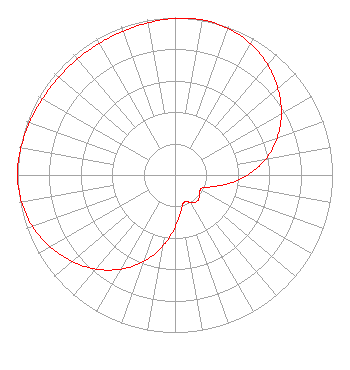 | |||||||||||||||||||||
| Azimuth | Ratio | Azimuth | Ratio | Azimuth | Ratio | Azimuth | Ratio | |||||||||||||||
| 5 | 0.999 | 10 | 1.000 | 15 | 0.997 | 25 | 0.978 | |||||||||||||||
| 35 | 0.940 | 45 | 0.885 | 55 | 0.818 | 65 | 0.737 | |||||||||||||||
| 75 | 0.640 | 85 | 0.526 | 95 | 0.398 | 105 | 0.273 | |||||||||||||||
| 115 | 0.193 | 125 | 0.189 | 135 | 0.213 | 140 | 0.217 | |||||||||||||||
| 145 | 0.213 | 155 | 0.189 | 160 | 0.182 | 165 | 0.193 | |||||||||||||||
| 175 | 0.273 | 185 | 0.398 | 195 | 0.526 | 205 | 0.640 | |||||||||||||||
| 215 | 0.737 | 225 | 0.818 | 235 | 0.885 | 245 | 0.940 | |||||||||||||||
| 255 | 0.978 | 265 | 0.997 | 270 | 1.000 | 275 | 0.999 | |||||||||||||||
| 285 | 0.988 | 295 | 0.976 | 305 | 0.967 | 315 | 0.963 | |||||||||||||||
| 325 | 0.963 | 335 | 0.967 | 345 | 0.976 | 355 | 0.988 | |||||||||||||||
Structure Registration Number 1042963 Structure Type: TOWER Registered To: Nexstar Media Inc. Structure Address: 5404 See Wee Rd Awendow, SC County Name: Charleston County ASR Issued: 05/28/2021 Date Built: 03/31/1987 Site Elevation: 5 m (16 ft.) Structure Height: 576 m (1890 ft.) Height Overall: 607 m (1991 ft.) Overall Height AMSL: 612 m (2008 ft.) FAA Determination: 11/22/1985 FAA Study #: 85-ASO-1425-OE FAA Circular #: 70/7460-1G Paint & Light FAA Chapters: 4, 7, 9 DUAL HIGH INTENSITY 32-56-25.0 N 79-41-44.0 W (NAD 83) 32-56-24.4 N 79-41-44.7 W (Converted to NAD 27) |
2000 West 41st Street Baltimore, MD 21211 Phone: 410-662-9688 Limited Liability Company | Title: President, Cunningham Broadcasting Corporation Date: 02/16/2022 Application Certifier WTAT Licensee, LLC Wtat Licensee, Llc 2000 West 41st Street Baltimore, MD 21211 Applicant Scott R. Flick, Esq Pillsbury Winthrop Shaw Pittman Llp 1200 Seventeenth Street, Nw Washington, DC 20036 | ||||||||||||||||||||
| ||||||||||||||||||||||
