
FCCInfo.com
A Service of Cavell, Mertz & Associates, Inc.
(855) FCC-INFO
|
|
|
|
|
||||||||||||||||
|
|
Status: Construction Permit (Licensed And Silent) Application Accepted: 02/17/2022 K06PT-D CP Expires: 02/22/2025 File Number: -0000184981 FCC Website Links: LMS Facility Details This Application Other K06PT-D Applications Including Superseded Applications Mailing Address Correspondence for K06PT-D Correspondence related to application -0000184981 Service Contour - Open Street Map or USGS Map (43 dBu) Service Contour - KML / Google Earth (43 dBu) Rabbit Ears Info Search for K06PT-D Site Location: 39-00-52.1 N 92-16-32.7 W (NAD 83) Site Location: 39-00-52.0 N 92-16-32.0 W (Converted to NAD 27) ERP: 3 kW Polarization: Horizontally polarized R/C AGL: 151 m (495 ft.) R/C AMSL: 405.5 m (1330 ft.) Emission Mask: Simple Site Elevation: 254.5 m. (835 ft.) Height Overall*: 319.7 m (1049 ft.) (* As Filed In This Application, may differ from ASR Data, Below.) Directional Antenna - Antenna Make/Model: Scala TVO-4 Antenna ID: 41530 Polarization: Horizontally polarized | ||||||||||||||||||
| Antenna Data for Antenna Id: 41530 K06PT-D LD File: -0000184981 Scala - TVO-4 Service: LD Standard Pattern: Y Pattern and Field Values Include a 70° Clockwise Rotation | 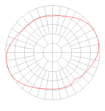 | ||||||||||||||||||
| Azimuth | Ratio | Azimuth | Ratio | Azimuth | Ratio | Azimuth | Ratio | ||||||||||||
| 0 | 0.774 | 10 | 0.788 | 20 | 0.818 | 30 | 0.857 | ||||||||||||
| 40 | 0.911 | 50 | 0.962 | 60 | 0.992 | 70 | 1.000 | ||||||||||||
| 80 | 0.992 | 90 | 0.962 | 100 | 0.911 | 110 | 0.857 | ||||||||||||
| 120 | 0.818 | 130 | 0.788 | 140 | 0.744 | 150 | 0.780 | ||||||||||||
| 160 | 0.780 | 170 | 0.780 | 180 | 0.776 | 190 | 0.782 | ||||||||||||
| 200 | 0.812 | 210 | 0.848 | 220 | 0.899 | 230 | 0.953 | ||||||||||||
| 240 | 0.988 | 250 | 1.000 | 260 | 0.992 | 270 | 0.962 | ||||||||||||
| 280 | 0.911 | 290 | 0.857 | 300 | 0.818 | 310 | 0.788 | ||||||||||||
| 320 | 0.774 | 330 | 0.780 | 340 | 0.780 | 350 | 0.780 | ||||||||||||
Structure Registration Number 1027181 Structure Type: GTOWER Registered To: VB Nimbus, LLC Structure Address: 6000 Brown Station Rd Columbia, MO County Name: Boone County ASR Issued: 10/13/2020 Date Built: 02/18/1998 Site Elevation: 254.5 m (835 ft.) Structure Height: 318.8 m (1046 ft.) Height Overall: 319.7 m (1049 ft.) Overall Height AMSL: 574.2 m (1884 ft.) FAA Determination: 07/19/2016 FAA Study #: 2015-ACE-3518-OE FAA Circular #: 70/7460-1L Paint & Light FAA Chapters: 3, 4, 5, 12 PRIOR STUDY 2009-ACE-2145-OE 39-00-52.1 N 92-16-32.7 W (NAD 83) 39-00-52.0 N 92-16-32.0 W (Converted to NAD 27) |
38955 Hills Tech Dr. Farmington Hills, MI 48331 Phone: 248-536-0776 Limited Liability Company | Title: Ceo Date: 02/17/2022 Application Certifier Innovative Media Technologies, Inc. 5174 Mcginnis Ferry Road Suite 133 Alpharetta, GA 30005 Applicant Susan Hansen B. W. St. Clair 2305 Vida Shaw Road New Iberia, LA 70563 | |||||||||||||||||