
FCCInfo.com
A Service of Cavell, Mertz & Associates, Inc.
(855) FCC-INFO
|
|
W30CV-D from 10/28/2005 W30CV-D from 10/06/1999 |
|
|
||||||||||||||||
|
|
Repacking Information: No changes Status: License Application Accepted: 06/28/2022 License Expires: 12/01/2020 File Number: -0000194091 FCC Website Links: LMS Facility Details This Application Other W30CV-D Applications Including Superseded Applications Mailing Address Correspondence for W30CV-D Correspondence related to application -0000194091 Service Contour - Open Street Map or USGS Map (51 dBu) Service Contour - KML / Google Earth (51 dBu) Public Inspection Files Rabbit Ears Info Search for W30CV-D Site Location: 32-13-39.1 N 80-51-14.8 W (NAD 83) Site Location: 32-13-38.4 N 80-51-15.4 W (Converted to NAD 27) ERP: 13.7 kW Polarization: Horizontally polarized Electrical Beam Tilt: 1.25 degrees R/C AGL: 144 m (472 ft.) R/C AMSL: 150.4 m (493 ft.) Emission Mask: Full Service Site Elevation: 6.4 m. (21 ft.) Height Overall*: 152.1 m (499 ft.) (* As Filed In This Application, may differ from ASR Data, Below.) Directional Antenna - Antenna Make/Model: Alive Telecom ATC-BCH510PR-30 Antenna ID: 1009714 Polarization: Horizontally polarized | ||||||||||||||||||
| Antenna Data for Antenna Id: 1009714 W30CV-D DC File: -0000194091 Alive Telecom - ATC-BCH510PR-30 Service: DC Standard Pattern: N | 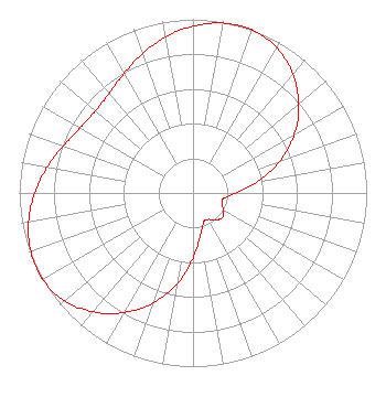 | ||||||||||||||||||
| Azimuth | Ratio | Azimuth | Ratio | Azimuth | Ratio | Azimuth | Ratio | ||||||||||||
| 0 | 0.961 | 10 | 0.993 | 17 | 1.000 | 20 | 0.998 | ||||||||||||
| 30 | 0.966 | 40 | 0.894 | 50 | 0.795 | 60 | 0.674 | ||||||||||||
| 70 | 0.531 | 80 | 0.377 | 90 | 0.247 | 100 | 0.179 | ||||||||||||
| 110 | 0.176 | 120 | 0.204 | 130 | 0.221 | 140 | 0.204 | ||||||||||||
| 150 | 0.176 | 160 | 0.179 | 170 | 0.247 | 180 | 0.377 | ||||||||||||
| 190 | 0.531 | 200 | 0.674 | 210 | 0.795 | 220 | 0.894 | ||||||||||||
| 230 | 0.966 | 240 | 0.998 | 243 | 1.000 | 250 | 0.993 | ||||||||||||
| 260 | 0.961 | 270 | 0.912 | 280 | 0.853 | 290 | 0.794 | ||||||||||||
| 300 | 0.750 | 310 | 0.734 | 320 | 0.750 | 330 | 0.794 | ||||||||||||
| 340 | 0.853 | 350 | 0.912 | ||||||||||||||||
Structure Registration Number 1045063 Structure Type: TOWER Registered To: Pinnacle Towers LLC Structure Address: 48 Ulmer Rd Bluffton, SC County Name: Beaufort County ASR Issued: 05/06/2016 Date Built: 07/23/2009 Site Elevation: 6.4 m (21 ft.) Structure Height: 146.3 m (480 ft.) Height Overall: 152.1 m (499 ft.) Overall Height AMSL: 158.5 m (520 ft.) FAA Determination: 06/08/2009 FAA Study #: 2009-ASO-3277-OE FAA Circular #: 70/7460-1K Paint & Light FAA Chapters: 4, 8, 12 PRIOR STUDY 2004-ASO-1106-OE 32-13-39.1 N 80-51-14.8 W (NAD 83) 32-13-38.4 N 80-51-15.4 W (Converted to NAD 27) |
2927 Devine St. Ste. 100 Columbia, SC 29205 Phone: 803-417-6380 Limited Liability Company | Title: President Date: 06/28/2022 Application Certifier Byrne Acquisition Group, Llc 2927 Devine St. Ste. 100 Columbia, SC 29205 Applicant Patrick Cross Brooks, Pierce Et Al. 150 Fayetteville Street Suite 1700 Raleigh, NC 27601 Timothy G. Nelson Brooks, Pierce Et Al. 150 Fayetteville Street Suite 1700 Raleigh, NC 27601 William Jeffrey Reynolds Du Treil, Lundin & Rackley Inc. 5212 Station Way Sarasota, FL 34233 Technical Consultant | |||||||||||||||||