
FCCInfo.com
A Service of Cavell, Mertz & Associates, Inc.
(855) FCC-INFO
|
|
WSLF-LD from 03/03/2005 WSLF-LD from 11/19/2001 WSLF-LD from 03/12/1999 |
|
|
||||||||||||||||
|
|
Status: License Application Accepted: 03/02/2022 License Expires: 02/01/2029 File Number: -0000185704 FCC Website Links: LMS Facility Details This Application Other WSLF-LD Applications Including Superseded Applications Mailing Address Correspondence for WSLF-LD Correspondence related to application -0000185704 Service Contour - Open Street Map or USGS Map (51 dBu) Service Contour - KML / Google Earth (51 dBu) Rabbit Ears Info Search for WSLF-LD Site Location: 27-07-17.5 N 80-23-57.8 W (NAD 83) Site Location: 27-07-16.3 N 80-23-58.6 W (Converted to NAD 27) ERP: 15 kW Polarization: Horizontally polarized Electrical Beam Tilt: 0.75 degrees R/C AGL: 122 m (400 ft.) R/C AMSL: 131.8 m (432 ft.) Emission Mask: Full Service Site Elevation: 9.8 m. (32 ft.) Height Overall*: 152.4 m (500 ft.) (* As Filed In This Application, may differ from ASR Data, Below.) Directional Antenna - Antenna Make/Model: Bogner B16UB Antenna ID: 18054 Polarization: Horizontally polarized | ||||||||||||||||||
| Antenna Data for Antenna Id: 18054 WSLF-LD LD File: -0000185704 Bogner - B16UB Service: LD Standard Pattern: Y Pattern and Field Values Include a 60° Clockwise Rotation | 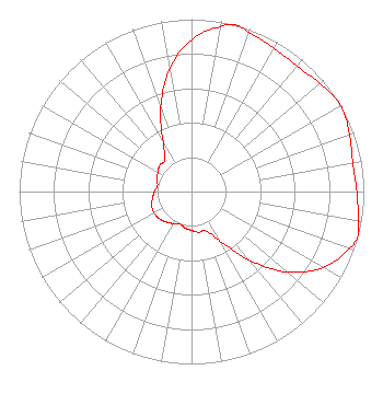 | ||||||||||||||||||
| Azimuth | Ratio | Azimuth | Ratio | Azimuth | Ratio | Azimuth | Ratio | ||||||||||||
| 0 | 0.880 | 10 | 0.970 | 15 | 1.000 | 20 | 0.980 | ||||||||||||
| 30 | 0.960 | 40 | 0.950 | 50 | 0.975 | 60 | 1.000 | ||||||||||||
| 70 | 0.975 | 80 | 0.950 | 90 | 0.960 | 100 | 0.980 | ||||||||||||
| 105 | 1.000 | 110 | 0.970 | 120 | 0.880 | 130 | 0.725 | ||||||||||||
| 140 | 0.520 | 150 | 0.330 | 160 | 0.240 | 170 | 0.240 | ||||||||||||
| 180 | 0.225 | 190 | 0.215 | 200 | 0.200 | 210 | 0.215 | ||||||||||||
| 220 | 0.230 | 230 | 0.245 | 240 | 0.250 | 250 | 0.245 | ||||||||||||
| 260 | 0.230 | 270 | 0.215 | 280 | 0.200 | 290 | 0.215 | ||||||||||||
| 300 | 0.225 | 310 | 0.240 | 320 | 0.240 | 330 | 0.330 | ||||||||||||
| 340 | 0.520 | 350 | 0.725 | ||||||||||||||||
Structure Registration Number 1018575 Structure Type: GTOWER Registered To: American Towers LLC Structure Address: 12008 Sw Martin Hwy (#5050) Palm City, FL County Name: Martin County ASR Issued: 01/03/2020 Date Built: 09/15/1997 Site Elevation: 9.8 m (32 ft.) Structure Height: 152.4 m (500 ft.) Height Overall: 152.4 m (500 ft.) Overall Height AMSL: 162.2 m (532 ft.) FAA Determination: 12/23/2019 FAA Study #: 2019-ASO-33911-OE FAA Circular #: 70/7460-1L Paint & Light FAA Chapters: 4, 8, 12 PRIOR STUDY 2007-ASO-893-OE 27-07-17.5 N 80-23-57.8 W (NAD 83) 27-07-16.3 N 80-23-58.6 W (Converted to NAD 27) |
3901 Highway 121 South Bedford, TX 76021 Phone: 817-571-1229 Not-for-Profit | Title: Manager Date: 03/02/2022 Application Certifier WORD OF GOD FELLOWSHIP, INC. Word Of God Fellowship, Inc. 3901 Highway 121 South Bedford, TX 76021 Applicant RICHARD C GOETZ R & L Media System 135 N Country Club Drive Hendersonville, TN 37075 BROADCAST CONSULTANT Robert L. Olender, Esq. Koernr & Olender P.c. 7020 Richard Drive Bethesda, MD 20817 LEGAL REPRESENTATIVE | |||||||||||||||||