
FCCInfo.com
A Service of Cavell, Mertz & Associates, Inc.
(855) FCC-INFO
|
|
KCWX from 05/29/2020 KCWX from 04/07/2006 KCWX from 05/15/1998 |
Virtual Channel 2 |  |
|
||||||||||||||||||||||
|
|
Repacking Information: No changes Status: Construction Permit Application Accepted: 03/28/2022 KCWX CP Expires: 11/30/2024 File Number: -0000187445 FCC Website Links: LMS Facility Details This Application Other KCWX Applications Including Superseded Applications Mailing Address Correspondence for KCWX Correspondence related to application -0000187445 Service Contour - Open Street Map or USGS Map (36 dBu) Service Contour - KML / Google Earth (36 dBu) Public Inspection Files Rabbit Ears Info Search for KCWX DTS Site Number: 4 Site Location: 29-18-46.1 N 99-21-37.4 W (NAD 83) Site Location: 29-18-45.3 N 99-21-36.2 W (Converted to NAD 27) ERP: 1 kW Polarization: Horizontally polarized HAAT: 111.8 m (367 ft.) R/C AGL: 93 m (305 ft.) R/C AMSL: 399.9 m (1312 ft.) Site Elevation: 306.9 m. (1007 ft.) Height Overall*: 112.8 m (370 ft.) (* As Filed In This Application, may differ from ASR Data, Below.) Directional Antenna - Antenna Make/Model: Scala CL-713 Antenna ID: 20786 Polarization: Horizontally polarized
| |||||||||||||||||||||||||
| Antenna Data for Antenna Id: 20786 KCWX DD File: -0000187445 Scala - CL-713 Service: DD Standard Pattern: Y Pattern and Field Values Include a 340° Clockwise Rotation | 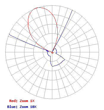 | |||||||||||||||||||||||||
| Azimuth | Ratio | Azimuth | Ratio | Azimuth | Ratio | Azimuth | Ratio | |||||||||||||||||||
| 0 | 0.810 | 10 | 0.590 | 20 | 0.325 | 30 | 0.010 | |||||||||||||||||||
| 40 | 0.010 | 50 | 0.010 | 60 | 0.010 | 70 | 0.010 | |||||||||||||||||||
| 80 | 0.010 | 90 | 0.010 | 100 | 0.010 | 110 | 0.010 | |||||||||||||||||||
| 120 | 0.030 | 130 | 0.030 | 140 | 0.030 | 150 | 0.030 | |||||||||||||||||||
| 160 | 0.030 | 170 | 0.030 | 180 | 0.030 | 190 | 0.020 | |||||||||||||||||||
| 200 | 0.010 | 210 | 0.010 | 220 | 0.010 | 230 | 0.010 | |||||||||||||||||||
| 240 | 0.010 | 250 | 0.010 | 260 | 0.010 | 270 | 0.010 | |||||||||||||||||||
| 280 | 0.010 | 290 | 0.050 | 300 | 0.380 | 310 | 0.606 | |||||||||||||||||||
| 320 | 0.800 | 330 | 0.945 | 340 | 1.000 | 350 | 0.945 | |||||||||||||||||||
Structure Registration Number 1233244 Structure Type: GTOWER Registered To: Crown Communication LLC Structure Address: 151 Cr 515 D'hanis, TX County Name: Medina County ASR Issued: 09/11/2020 Date Built: 03/28/2002 Site Elevation: 306.9 m (1007 ft.) Structure Height: 106.6 m (350 ft.) Height Overall: 112.8 m (370 ft.) Overall Height AMSL: 419.7 m (1377 ft.) FAA Determination: 08/21/2012 FAA Study #: 2012-ASW-5308-OE FAA Circular #: 70/7460-1K Paint & Light FAA Chapters: 4, 8, 12 PRIOR STUDY 2010-ASW-434-OE 29-18-46.1 N 99-21-37.4 W (NAD 83) 29-18-45.3 N 99-21-36.2 W (Converted to NAD 27) |
1402 West Avenue Austin, TX 78701 Phone: 512-391-0641 Limited Liability Partnership | Title: Managing Partner Date: 03/28/2022 Application Certifier CORRIDOR TELEVISION, L.L.P. Corridor Television, L.l.p. 1402 West Avenue Austin, TX 78701 Applicant Kevin Fisher Smith And Fisher, Llc 4791 Wintergreen Court Woodbridge, VA 22192 Jonathan Mark, Esq Davis Wright Tremaine Llp 1301 K Street, N.w. Suite 500 East Washington, DC 20005 | ||||||||||||||||||||||||
| ||||||||||||||||||||||||||
